Great Nicobar
Welcome to Great Nicobar, a Tropical island in the Bay of Bengal, part of the majestic Indian Ocean. This guide offers a comprehensive overview of what makes Great Nicobar unique – from its geography and climate to its population, infrastructure, and beyond. Dive into the details:
- Geography and Size: Explore the island’s size and location.
- Climate and Weather: Weather patterns and temperature.
- Topography and Nature: Uncover the natural wonders of the island.
- Infrastructure and Travelling: Insights on reaching, staying, and making the most of your visit.
- News and Headlines: Latest News.
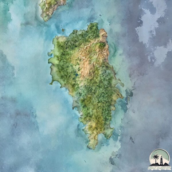
Geography and size of Great Nicobar
Size: 911.1 km²
Coastline: 290.3 km
Ocean: Indian Ocean
Sea: Bay of Bengal
Continent: Seven seas (open ocean)
Great Nicobar is a Large Island spanning 911 km² with a coastline of 290 km.
Archipel: Nicobar Islands – Part of a group of islands in the Indian Ocean, these are known for their stunning beaches, diverse ecosystems, and unique indigenous cultures.
Tectonic Plate: Burma – Also known as the Burma Plate, it’s a minor tectonic plate in Southeast Asia, largely covering Burma (Myanmar) and parts of the Indian Ocean. It’s involved in the subduction process under the Eurasian Plate, contributing to seismic activity in the region.
The geographic heart of the island is pinpointed at these coordinates:
Latitude: 7.02878623 / Longitude: 93.80752384
Climate and weather of Great Nicobar
Climate Zone: Tropical
Climate Details: Tropical Rainforest Climate
Temperature: Hot
Climate Characteristics: This climate is typified by heavy rainfall throughout the year, high humidity, and consistently high temperatures, leading to lush rainforests and rich biodiversity. Seasonal temperature variations are minimal.
Topography and nature of Great Nicobar
Timezone: UTC+05:30
Timezone places:
Max. Elevation: 527 m
Mean Elevation: 114 m
Vegetation: Evergreen Broadleaf Forest
Tree Coverage: 66%
The mean elevation is 114 m. The highest elevation on the island reaches approximately 527 meters above sea level. The island is characterized by Plateau: Elevated flatlands rising sharply above the surrounding area, with a maximum elevation over 500 meters but a mean elevation less than 300 meters, forming unique highland areas on islands.
Dominating Vegetation: Evergreen Broadleaf Forest
Characterized by dense, lush canopies of broadleaf trees that retain their leaves year-round. These forests are typically found in tropical and subtropical regions and are known for their high biodiversity. Great Nicobar has a tree cover of 66 %.
Vegetation: 15 vegetation zones – Exceptionally Diverse Island
Islands with more than ten vegetation zones are among the most ecologically rich and varied in the world. These islands are akin to miniature continents, boasting an incredible array of ecosystems. The sheer range of habitats, from high peaks to deep valleys, rainforests to deserts, creates a mosaic of life that is unparalleled. They are crucial for conservation and ecological studies.
Infrastructure and Travelling to Great Nicobar
Does the island have a public airport? no.
There is no public and scheduled airport on Great Nicobar. The nearest airport is Sultan Iskandar Muda International Airport, located 221 km away.
Does the island have a major port? no.
There are no major ports on Great Nicobar. The closest major port is SABANG, approximately 188 km away.
The mean population of Great Nicobar is 7 per km². Great Nicobar is Gently Populated. The island belongs to India.
The name of the island resonates across different cultures and languages. Here is how it is known around the world: Arabic: جزيرة نيكوبار الكبرى; German: Groß Nikobar; Spanish: Isla Gran Nicobar; French: Grande Nicobar; Portuguese: Grande Nicobar; Russian: Большой Никобар; Chinese: 大尼科巴島
Continuing your journey, Little Nicobar is the next notable island, situated merely km away.
How Great Nicobar Hosts Some of the Rarest Creatures in the World


India is classified as Emerging region: BRIC: Brazil, Russia, India, and China – Economies noted for their rapid growth and increasing influence on global affairs. The level of income is Lower middle income.
News – Latest Updates and Headlines from Great Nicobar
Stay informed with the most recent news and important headlines from Great Nicobar. Here’s a roundup of the latest developments.
Please note: The data used here has been primarily extracted from satellite readings. Deviations from exact values may occur, particularly regarding the height of elevations and population density. Land area and coastline measurements refer to average values at mean high tide.