Greenland
Welcome to Greenland, a Polar island in the Lincoln Sea, part of the majestic Arctic Ocean. This guide offers a comprehensive overview of what makes Greenland unique – from its geography and climate to its population, infrastructure, and beyond. Dive into the details:
- Geography and Size: Explore the island’s size and location.
- Climate and Weather: Weather patterns and temperature.
- Topography and Nature: Uncover the natural wonders of the island.
- Infrastructure and Travelling: Insights on reaching, staying, and making the most of your visit.
- News and Headlines: Latest News.
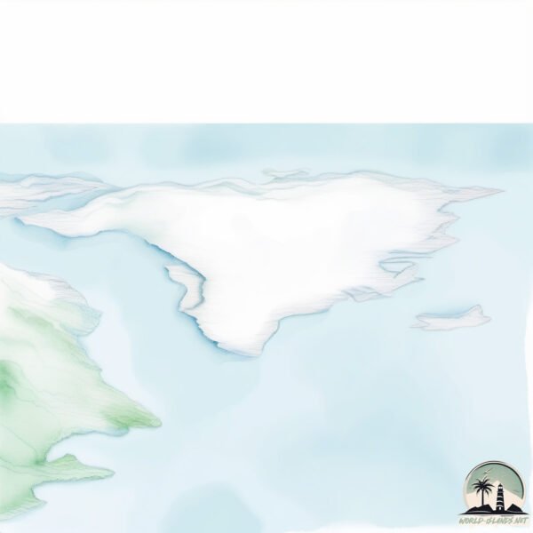
Geography and size of Greenland
Size: 2108459 km²
Coastline: 59159 km
Ocean: Arctic Ocean
Sea: Lincoln Sea
Continent: North America
Greenland is a Colossal Island spanning 2108459 km² with a coastline of 59159 km.
Archipel: Canadian Arctic Archipelago – A vast and remote region in northern Canada, consisting of a series of large and small islands known for their extreme Arctic environment and unique wildlife.
Tectonic Plate: North America – Covers North America and parts of the Atlantic and Arctic Oceans, characterized by diverse geological features and varying levels of seismic activity.
The geographic heart of the island is pinpointed at these coordinates:
Latitude: 74.79339564 / Longitude: -41.33711221
Climate and weather of Greenland
Climate Zone: Polar
Climate Details: Ice Cap
Temperature: Cold
Climate Characteristics: The ice cap climate is the most extreme of the polar climates, characterized by a permanently frozen landscape. Temperatures rarely, if ever, rise above freezing, resulting in a barren, ice-covered environment with very little precipitation and no plant or animal life.
Topography and nature of Greenland
Timezone: UTC-01:00
Timezone places: America/Scoresbysund
Max. Elevation: 3694 m Gunnbjørn Fjeld
Mean Elevation: 1868 m
Vegetation: Snow and Ice Covered
Tree Coverage: 7%
The mean elevation is 1868 m. Dominating the island’s landscape, the majestic “Gunnbjørn Fjeld” rises as the highest peak, soaring to impressive heights. The island is characterized by Mountains: High, steeply elevated landforms. Characterized by both a high maximum elevation (over 500 meters) and a high mean elevation, creating rugged, mountainous terrains on islands.
Dominating Vegetation: Snow and Ice Covered
These areas are permanently or seasonally covered in snow and ice, with little to no vegetation, such as polar regions and high mountains. Greenland has a tree cover of 7 %.
Vegetation: 10 vegetation zones – Very Highly Diverse Island
Islands in this range are ecological powerhouses, showcasing a wide array of vegetation zones. Each zone, from lush rainforests to arid scrublands, coastal mangroves to mountainous regions, contributes to a complex and interdependent ecosystem. These islands are often hotspots of biodiversity, supporting numerous species and intricate ecological processes.
Infrastructure and Travelling to Greenland
Does the island have a public airport? yes.
Greenland has a public and scheduled airport. The following airports are located on this island: Alluitsup Paa Heliport, Aappilattoq Heliport, Ammassivik Heliport, Narsarsuaq Airport, Qasigiannguit Heliport, Neerlerit Inaat Airport, Narsarmijit Heliport, Nuuk Airport, Iginniarfik Heliport, Ikerassaarsuk Heliport, Ilimanaq Heliport, Ikamiut Heliport, Qaqortoq Heliport, Ilulissat Airport, Kangaatsiaq Heliport, Kuummiut Heliport, Moriusaq Heliport, Niaqornaarsuk Heliport, Narsaq Heliport, Nuussuaq Heliport, Paamiut Airport, Qaanaaq Airport, Ittoqqortoormiit Heliport, Kangerlussuaq Airport, Sermiligaaq Heliport, Siorapaluk Heliport, Saqqaq Heliport, Sisimiut Airport, Pituffik Space Base, Tiniteqilaaq Heliport, Tasiusaq Heliport, Qaarsut Airport, Igaliku Heliport.
Does the island have a major port? yes.
Greenland is home to a major port. The following ports are situated on the island: PAAMUIT (FREDERIKSHAB), ILLULISSAT (JAKOBSHAVN), NARSAQ, NARSARSSUAQ, GRONNEDAL (KANGILINNGUIT).
The mean population of Greenland is 0 per km². Greenland is Uninhabited. The island belongs to Denmark.
The name of the island resonates across different cultures and languages. Here is how it is known around the world: Arabic: جزيرة غرينلاند; German: Grönland; Spanish: Groenlandia; French: Groenland; Portuguese: Groenlândia; Russian: Гренландия; Chinese: 格陵兰岛
Continuing your journey, Stor is the next notable island, situated merely km away.
Why Greenland Is Ice and Iceland Is Green ❄️ Name Mix-Up 🤯


Denmark is classified as Developed region: nonG7: Developed economies outside of the Group of Seven, characterized by high income and advanced economic structures. The level of income is High income: OECD.
News – Latest Updates and Headlines from Greenland
Stay informed with the most recent news and important headlines from Greenland. Here’s a roundup of the latest developments.
Social Media Posts about Greenland
Please note: The data used here has been primarily extracted from satellite readings. Deviations from exact values may occur, particularly regarding the height of elevations and population density. Land area and coastline measurements refer to average values at mean high tide.