Groot Eylandt
Welcome to Groot Eylandt, a Tropical island in the Arafura Sea, part of the majestic Indian Ocean. This guide offers a comprehensive overview of what makes Groot Eylandt unique – from its geography and climate to its population, infrastructure, and beyond. Dive into the details:
- Geography and Size: Explore the island’s size and location.
- Climate and Weather: Weather patterns and temperature.
- Topography and Nature: Uncover the natural wonders of the island.
- Infrastructure and Travelling: Insights on reaching, staying, and making the most of your visit.
- News and Headlines: Latest News.
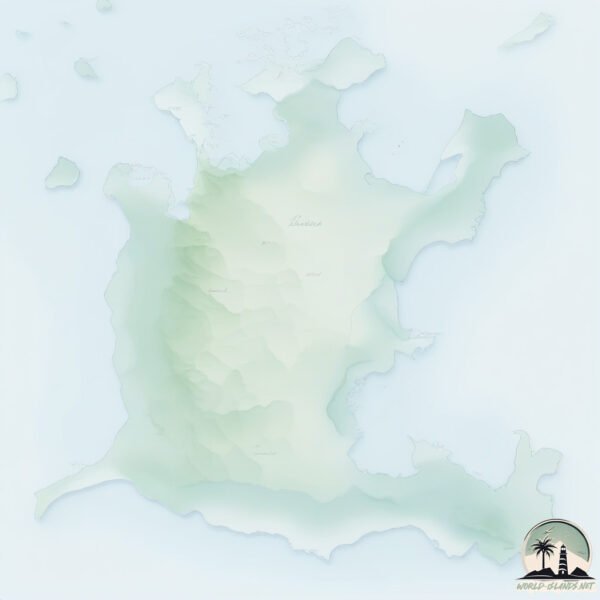
Geography and size of Groot Eylandt
Size: 2290 km²
Coastline: 598 km
Ocean: Indian Ocean
Sea: Arafura Sea
Continent: Oceania
Groot Eylandt is a Very Large Island spanning 2290 km² with a coastline of 598 km.
Archipel: –
Tectonic Plate: Australia – A major tectonic plate covering Australia, New Zealand, and parts of the Indian and Pacific Oceans, known for its relative stability and occasional seismic activity.
The geographic heart of the island is pinpointed at these coordinates:
Latitude: -14.02236848 / Longitude: 136.63844807
Climate and weather of Groot Eylandt
Climate Zone: Tropical
Climate Details: Tropical Savanna, Wet
Temperature: Hot
Climate Characteristics: Defined by distinct wet and dry seasons with high temperatures year-round. Pronounced rainfall occurs during the wet season, while the dry season is marked by drought.
Topography and nature of Groot Eylandt
Timezone: UTC+09:30
Timezone places: Australia/Adelaide
Max. Elevation: 162 m
Mean Elevation: 44 m
Vegetation: Evergreen Broadleaf Forest
Tree Coverage: 29%
The mean elevation is 44 m. The highest elevation on the island reaches approximately 162 meters above sea level. The island is characterized by Plains: Flat, low-lying lands characterized by a maximum elevation of up to 200 meters. On islands, plains are typically coastal lowlands or central flat areas.
Dominating Vegetation: Evergreen Broadleaf Forest
Characterized by dense, lush canopies of broadleaf trees that retain their leaves year-round. These forests are typically found in tropical and subtropical regions and are known for their high biodiversity. Groot Eylandt has a tree cover of 29 %.
Vegetation: 11 vegetation zones – Exceptionally Diverse Island
Islands with more than ten vegetation zones are among the most ecologically rich and varied in the world. These islands are akin to miniature continents, boasting an incredible array of ecosystems. The sheer range of habitats, from high peaks to deep valleys, rainforests to deserts, creates a mosaic of life that is unparalleled. They are crucial for conservation and ecological studies.
Infrastructure and Travelling to Groot Eylandt
Does the island have a public airport? yes.
Groot Eylandt has a public and scheduled airport. The following airports are located on this island: Groote Eylandt Airport.
Does the island have a major port? no.
There are no major ports on Groot Eylandt. The closest major port is MILNER BAY, approximately 1 km away.
The mean population of Groot Eylandt is 1 per km². Groot Eylandt is Gently Populated. The island belongs to Australia.
The name of the island resonates across different cultures and languages. Here is how it is known around the world: Arabic: غروت آيلاند; German: Groote Eylandt; Spanish: Groote Eylandt; French: Groote Eylandt; Portuguese: Groote Eylandt; Russian: остров Грут-Айленд; Chinese: 格鲁特岛
Continuing your journey, Winchelsea is the next notable island, situated merely km away.
🔥 EPIC DAY/NIGHT 4WDING — Towing 7M TRAILERS through GROOTE EYLANDT (Australia)


Australia is classified as Developed region: nonG7: Developed economies outside of the Group of Seven, characterized by high income and advanced economic structures. The level of income is High income: OECD.
News – Latest Updates and Headlines from Groot Eylandt
Stay informed with the most recent news and important headlines from Groot Eylandt. Here’s a roundup of the latest developments.
Social Media Posts about Groot Eylandt
Please note: The data used here has been primarily extracted from satellite readings. Deviations from exact values may occur, particularly regarding the height of elevations and population density. Land area and coastline measurements refer to average values at mean high tide.