Guadeloupe
Welcome to Guadeloupe, a Tropical island in the Caribbean Sea, part of the majestic Atlantic Ocean. This guide offers a comprehensive overview of what makes Guadeloupe unique – from its geography and climate to its population, infrastructure, and beyond. Dive into the details:
- Geography and Size: Explore the island’s size and location.
- Climate and Weather: Weather patterns and temperature.
- Topography and Nature: Uncover the natural wonders of the island.
- Infrastructure and Travelling: Insights on reaching, staying, and making the most of your visit.
- News and Headlines: Latest News.
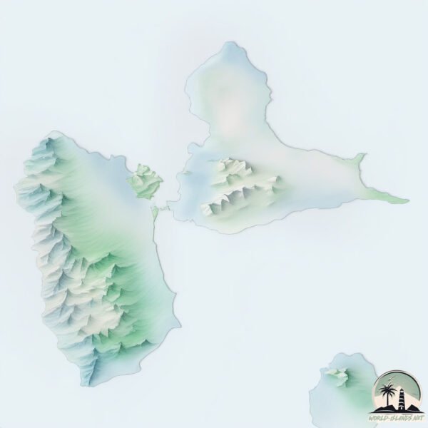
Geography and size of Guadeloupe
Size: 1452 km²
Coastline: 343 km
Ocean: Atlantic Ocean
Sea: Caribbean Sea
Continent: North America
Guadeloupe is a Very Large Island spanning 1452 km² with a coastline of 343 km.
Archipel: Lesser Antilles – A long arc of small islands in the Caribbean Sea, stretching from the Virgin Islands to Trinidad, known for their distinct cultures and tropical landscapes.
Tectonic Plate: Caribbean – Covering the Caribbean Sea and surrounding regions, this plate is bordered by the North American Plate and the South American Plate. Known for seismic activity, including earthquakes and volcanic eruptions, and features like the Puerto Rico Trench.
The geographic heart of the island is pinpointed at these coordinates:
Latitude: 16.22799521 / Longitude: -61.57595982
Climate and weather of Guadeloupe
Climate Zone: Tropical
Climate Details: Tropical Monsoon Climate
Temperature: Hot
Climate Characteristics: Characterized by heavy rainfall, high humidity, and uniformly high temperatures, but with a distinct short dry season. It features a seasonal reversal of prevailing wind directions.
Topography and nature of Guadeloupe
Timezone: UTC-04:00
Timezone places: America/La_Paz
Max. Elevation: 1330 m
Mean Elevation: 187 m
Vegetation: Evergreen Broadleaf Forest
Tree Coverage: 45%
The mean elevation is 187 m. The highest elevation on the island reaches approximately 1330 meters above sea level. The island is characterized by Plateau: Elevated flatlands rising sharply above the surrounding area, with a maximum elevation over 500 meters but a mean elevation less than 300 meters, forming unique highland areas on islands.
Dominating Vegetation: Evergreen Broadleaf Forest
Characterized by dense, lush canopies of broadleaf trees that retain their leaves year-round. These forests are typically found in tropical and subtropical regions and are known for their high biodiversity. Guadeloupe has a tree cover of 45 %.
Vegetation: 15 vegetation zones – Exceptionally Diverse Island
Islands with more than ten vegetation zones are among the most ecologically rich and varied in the world. These islands are akin to miniature continents, boasting an incredible array of ecosystems. The sheer range of habitats, from high peaks to deep valleys, rainforests to deserts, creates a mosaic of life that is unparalleled. They are crucial for conservation and ecological studies.
Infrastructure and Travelling to Guadeloupe
Does the island have a public airport? yes.
Guadeloupe has a public and scheduled airport. The following airports are located on this island: Basse-Terre Baillif Airport, St-François Airport, Pointe-à-Pitre Le Raizet International Airport.
Does the island have a major port? yes.
Guadeloupe is home to a major port. The following ports are situated on the island: BASSE TERRE, PORT LOUIS, POINTE A PITRE.
The mean population of Guadeloupe is 283 per km². Guadeloupe is Moderately Inhabited. The island belongs to France.
Continuing your journey, La Désirade is the next notable island, situated merely km away.
Arriving in Guadeloupe #travel #caribbean #guadeloupe #flight #wanderlust


France is classified as Developed region: G7: Group of Seven – Major advanced economies, including Canada, France, Germany, Italy, Japan, the United Kingdom, and the United States. The level of income is High income: OECD.
News – Latest Updates and Headlines from Guadeloupe
Stay informed with the most recent news and important headlines from Guadeloupe. Here’s a roundup of the latest developments.
Social Media Posts about Guadeloupe
Please note: The data used here has been primarily extracted from satellite readings. Deviations from exact values may occur, particularly regarding the height of elevations and population density. Land area and coastline measurements refer to average values at mean high tide.