Gueguensi
Welcome to Gueguensi, a Tropical island in the North Pacific Ocean, part of the majestic Pacific Ocean. This guide offers a comprehensive overview of what makes Gueguensi unique – from its geography and climate to its population, infrastructure, and beyond. Dive into the details:
- Geography and Size: Explore the island’s size and location.
- Climate and Weather: Weather patterns and temperature.
- Topography and Nature: Uncover the natural wonders of the island.
- Infrastructure and Travelling: Insights on reaching, staying, and making the most of your visit.
- News and Headlines: Latest News.
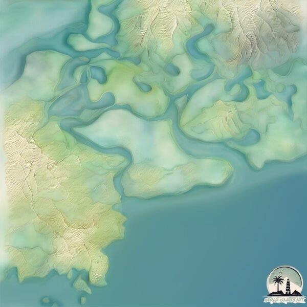
Geography and size of Gueguensi
Size: 7.298 km²
Coastline: 14.3 km
Ocean: Pacific Ocean
Sea: North Pacific Ocean
Continent: North America
Gueguensi is a Small Island spanning 7.3 km² with a coastline of 14.3 km.
Archipel: –
Tectonic Plate: Caribbean – Covering the Caribbean Sea and surrounding regions, this plate is bordered by the North American Plate and the South American Plate. Known for seismic activity, including earthquakes and volcanic eruptions, and features like the Puerto Rico Trench.
The geographic heart of the island is pinpointed at these coordinates:
Latitude: 13.34731227 / Longitude: -87.56657975
Climate and weather of Gueguensi
Climate Zone: Tropical
Climate Details: Tropical Savanna, Wet
Temperature: Hot
Climate Characteristics: Defined by distinct wet and dry seasons with high temperatures year-round. Pronounced rainfall occurs during the wet season, while the dry season is marked by drought.
Topography and nature of Gueguensi
Timezone: UTC-06:00
Timezone places: America/Chicago
Max. Elevation: 16 m
Mean Elevation: 7 m
Vegetation: Mangrove Forest
Tree Coverage: 68%
The mean elevation is 7 m. The highest elevation on the island reaches approximately 16 meters above sea level. The island is characterized by Plains: Flat, low-lying lands characterized by a maximum elevation of up to 200 meters. On islands, plains are typically coastal lowlands or central flat areas.
Dominating Vegetation: Mangrove Forest
Found in coastal areas and river deltas, these unique wetland ecosystems are adapted to saline conditions and are crucial for coastal protection and biodiversity. Gueguensi has a tree cover of 68 %.
Vegetation: 4 vegetation zones – Diverse Island
Four distinct vegetation zones mark these islands as ecologically diverse. They might feature varied landscapes such as forests, beaches, grasslands, and rocky areas. Such diversity reflects the island’s complex ecological interactions and varied habitats, which can support a rich array of wildlife and plant species.
Infrastructure and Travelling to Gueguensi
Does the island have a public airport? no.
There is no public and scheduled airport on Gueguensi. The nearest airport is Toncontín International Airport, located 87 km away.
Does the island have a major port? no.
There are no major ports on Gueguensi. The closest major port is PUERTO DE HENCAN, approximately 12 km away.
The mean population of Gueguensi is 20 per km². Gueguensi is Gently Populated. The island belongs to Honduras.
Continuing your journey, Varillas de Barrancones is the next notable island, situated merely km away.
El Salvador, Conchaguita Island, Gulf of Fonseca, La Union Dept, Tourist Info, Central America
![[Case Explained] Gulf of Fonseca](https://i.ytimg.com/vi/eAPasvJdSvM/mqdefault.jpg)
Honduras is classified as Developing region: Regions characterized by lower income levels, with economies in the process of industrialization and modernization. The level of income is Lower middle income.
News – Latest Updates and Headlines from Gueguensi
Stay informed with the most recent news and important headlines from Gueguensi. Here’s a roundup of the latest developments.
Please note: The data used here has been primarily extracted from satellite readings. Deviations from exact values may occur, particularly regarding the height of elevations and population density. Land area and coastline measurements refer to average values at mean high tide.