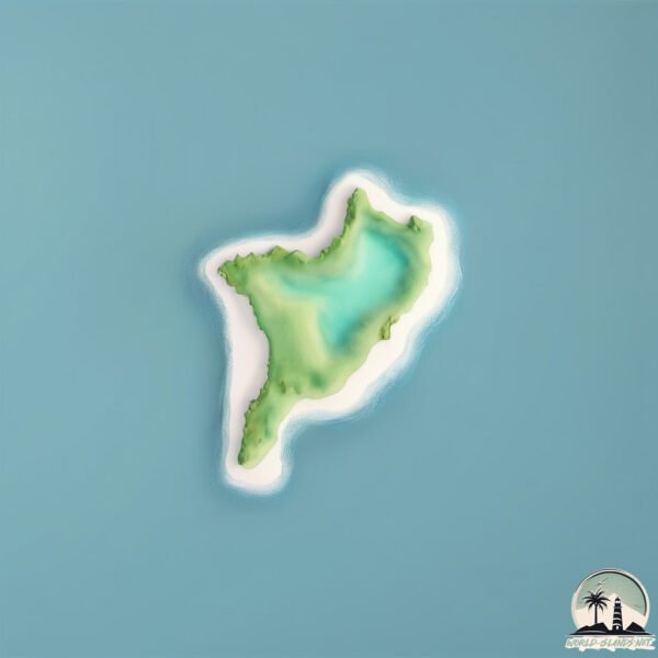
Welcome to Gui Zhou, a Temperate island in the South China Sea, part of the majestic Pacific Ocean. This guide offers a comprehensive overview of what makes Gui Zhou unique – from its geography and climate to its population, infrastructure, and beyond. Dive into the details:
Geography and size of Gui Zhou
Size: 0.372 km²
Coastline: 2.7 km
Ocean: Pacific Ocean
Sea: South China Sea
Continent: Asia
Gui Zhou is a Tiny Island spanning 0.372 km² with a coastline of 2.7 km.
Archipel: –
Tectonic Plate: Yangtze – A minor tectonic plate in East Asia, often considered a part of the Eurasian Plate. It’s primarily continental and covers the Yangtze River area in China, playing a significant role in the region’s geological stability.
The geographic heart of the island is pinpointed at these coordinates:
Latitude: 21.98446403 / Longitude: 113.78893348
Climate and weather of Gui Zhou
Climate Zone: Temperate
Climate Details: Monsoon-Influenced Humid Subtropical Climate
Temperature: Hot Summer
Climate Characteristics: Known for hot, humid summers with significant monsoon rains, contrasted by mild, drier winters.
Topography and nature of Gui Zhou
Timezone: UTC+08:00
Timezone places: Australia/Perth
Max. Elevation: 9 m
Mean Elevation: 5 m
Vegetation: Deciduous Broadleaf Forest
Tree Coverage: 68%
The mean elevation is 5 m. The highest elevation on the island reaches approximately 9 meters above sea level. The island is characterized by Plains: Flat, low-lying lands characterized by a maximum elevation of up to 200 meters. On islands, plains are typically coastal lowlands or central flat areas.
Dominating Vegetation: Deciduous Broadleaf Forest
Composed of broadleaf trees that shed their leaves seasonally. These forests are commonly found in temperate zones and experience distinct seasonal changes. Gui Zhou has a tree cover of 68 %.
Vegetation: 1 vegetation zones – Minimal Diversity Island
These islands exhibit the most basic level of ecological diversity, often characterized by a single dominant vegetation type. This could be due to extreme environmental conditions, limited land area, or significant human impact. They represent unique ecosystems where specific species have adapted to thrive in these singular environments.
Infrastructure and Travelling to Gui Zhou
Does the island have a public airport? no.
There is no public and scheduled airport on Gui Zhou. The nearest airport is Macau International Airport, located 28 km away.
Does the island have a major port? no.
There are no major ports on Gui Zhou. The closest major port is MACAU, approximately 33 km away.
The mean population of Gui Zhou is 48 per km². Gui Zhou is Gently Populated. The island belongs to China.
Continuing your journey, Taipa is the next notable island, situated merely km away.
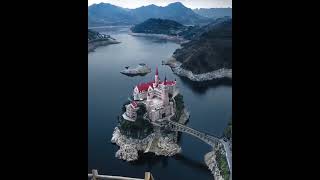
A fairy-tale castle on Guizhou island, China.Сказочный замок на острове Гуйчжоу, Китай.
YOUR SOURCE FOR ALL TRENDY PRODUCTS ...
Many mansions have been built on an island in Guizhou
Which is too big to live Make $10 Dollars In 2 Minutes! Join here: ...
Amazing Place View_The castle on an isolated island in Guizhou,
The castle on an isolated island in Guizhou, I don't know which local ...
The castle on an isolated island in Guizhou, I don't know which local tyrant's home is. It is estimated to be tens of thousands of ...
A European-style castle is built in one water in Guizhou, occupying a full island
A European-style castle is built in one water in Guizhou, occupying a ...
A European-style castle is built in one water in Guizhou, occupying a full island. Is it a scenic spot or a private mansion?
A small island in Guizhou, who is so rich to build such a big house on it, a fairyland on earth! #快手
Most Beautiful Places in the World,Beautiful Place,Most Beautiful ...
Most Beautiful Places in the World,Beautiful Place,Most Beautiful Place,unbelievable places,best places,top most beautiful,best ...
This Floating Road Shouldn’t Exist… China’s Stunning Guizhou Water Highway
Imagine driving on a road that seems to float on water — surrounded by ...
Imagine driving on a road that seems to float on water — surrounded by mountains, mist, and serenity. Welcome to the ...
Good idea.Duyun, Guizhou, built a small island into a sports center.😁😁😁
Good idea.Duyun, Guizhou, built a small island into a sports center.
Good idea.Duyun, Guizhou, built a small island into a sports center.
A strange island was found in the deep mountains of Guizhou. It looks like a carp from above. It
A strange island was found in the deep mountains of Guizhou. It looks ...
A strange island was found in the deep mountains of Guizhou. It looks like a carp from above. It.
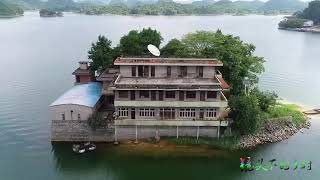
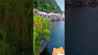
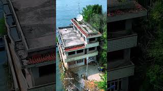
A four-story building is built on an isolated island in Guizhou without a bridge.
A four-story building is built on an isolated island in Guizhou. There ...
A four-story building is built on an isolated island in Guizhou. There is no bridge. How can the materials be transported? Located ...
5 Things To Do in Guizhou
Looking for more things to do in Guizhou? Check out ...
Looking for more things to do in Guizhou? Check out ...
Guizhou Expressway can turn around #travel #chinatourism #discoverchina
discoverchina #amazingchina.
discoverchina #amazingchina.
2 million years old #glacier mills were unearthed in SW China's Guizhou
2 million years old #glacier mills were unearthed in SW China's ...
2 million years old #glacier mills were unearthed in SW China's Guizhou as the waterline drops. The aerial video takes you to ...
Fanjingshan, China - The Sacred Mountain of Guizhou - Travel Documentary
Fanjingshan, China - The Sacred Mountain of Guizhou - Travel ...
Fanjingshan, China - The Sacred Mountain of Guizhou - Travel Documentary Fanjingshan (Mount Fanjing), Guizhou ...
Weining, Guizhou, "Pipa Island", I am willing to live here for the rest of my life
Enter a parallel world! In Guizhou, we admire the most spectacular mountains and underground rivers
409.9 kilometers! This is the length of Guizhou's Shuanghe Cave, the ...
409.9 kilometers! This is the length of Guizhou's Shuanghe Cave, the largest in Asia and the third largest in the world, equivalent ...
Zhenyuan Ancient Town, Guizhou, China
Zhenyuan Ancient Town is a town under the jurisdiction of Zhenyuan ...
Zhenyuan Ancient Town is a town under the jurisdiction of Zhenyuan County, Qiandongnan Miao and Dong Autonomous ...
Liupanshui High speed Railway in Guizhou Province #travel #discoverchina
beautiful.
beautiful.
The biggest teapot in Guizhou China
teapot #biggest #china #Guizhou.
teapot #biggest #china #Guizhou.
A lifetime: Romantic life on a small island in Guizhou Lake!
There is a family living on a small island in Guizhou Lake, and they ...
There is a family living on a small island in Guizhou Lake, and they also raise small animals. It is really a paradise on earth.
Guizhou Weining Yangwan Bridge Someone built a courtyard on an isolated island in the middle of the
Guizhou Weining Yangwan Bridge Someone built a courtyard on an ...
Guizhou Weining Yangwan Bridge Someone built a courtyard on an isolated island in the middle of the.
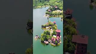
Tucked in Guizhou’s Qianxinan ranges, a secret QianDaoLake
Tucked in Guizhou's Qianxinan ranges, a secret ...
Tucked in Guizhou's Qianxinan ranges, a secret QianDaoLake(Thousand-Island Lake) spreads jade water over ninety-plus karst ...
A mysterious structure on an island in Guizhou
mysterious structure on an island in Guizhou #China #structure #island.
mysterious structure on an island in Guizhou #China #structure #island.
Only in Guizhou EP04: The future of Guizhou
The data expo, a grand event that affects the world, is held here, ...
The data expo, a grand event that affects the world, is held here, where 300 leading scientific and technological companies gather ...
A boss from Guizhou built a building on the island
A boss from Guizhou built a building on the island Make $10 Dollars In ...
A boss from Guizhou built a building on the island Make $10 Dollars In 2 Minutes! Join here: ...
China is classified as Emerging region: BRIC: Brazil, Russia, India, and China – Economies noted for their rapid growth and increasing influence on global affairs. The level of income is Upper middle income.
News – Latest Updates and Headlines from Gui Zhou
Stay informed with the most recent news and important headlines from Gui Zhou. Here’s a roundup of the latest developments.
Loading...
Please note: The data used here has been primarily extracted from satellite readings. Deviations from exact values may occur, particularly regarding the height of elevations and population density. Land area and coastline measurements refer to average values at mean high tide.