Welcome to Halls Pond Cay, a Tropical island in the North Atlantic Ocean, part of the majestic Atlantic Ocean. This guide offers a comprehensive overview of what makes Halls Pond Cay unique – from its geography and climate to its population, infrastructure, and beyond. Dive into the details:
Geography and size of Halls Pond Cay
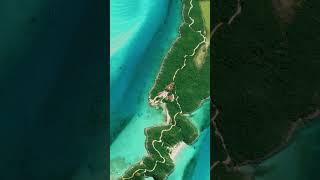
Size: 1.96 km²
Coastline: 10.2 km
Ocean: Atlantic Ocean
Sea: North Atlantic Ocean
Continent: North America
Halls Pond Cay is a Small Island spanning 2 km² with a coastline of 10.2 km.
Archipel: Bahama Islands – An archipelago in the Atlantic Ocean, known for their stunning beaches, coral reefs, and vibrant culture.
Tectonic Plate: North America – Covers North America and parts of the Atlantic and Arctic Oceans, characterized by diverse geological features and varying levels of seismic activity.
The geographic heart of the island is pinpointed at these coordinates:
Latitude: 24.35774518 / Longitude: -76.5828825
Climate and weather of Halls Pond Cay
Climate Zone: Tropical
Climate Details: Tropical Savanna, Wet
Temperature: Hot
Climate Characteristics: Defined by distinct wet and dry seasons with high temperatures year-round. Pronounced rainfall occurs during the wet season, while the dry season is marked by drought.
Topography and nature of Halls Pond Cay
Timezone: UTC-05:00
Timezone places: America/New_York
Max. Elevation: 6 m
Mean Elevation: -5 m
Vegetation: Deciduous Needleleaf Forest
Tree Coverage: 87%
The mean elevation is -5 m. The highest elevation on the island reaches approximately 6 meters above sea level. The island is characterized by Plains: Flat, low-lying lands characterized by a maximum elevation of up to 200 meters. On islands, plains are typically coastal lowlands or central flat areas.
Dominating Vegetation: Deciduous Needleleaf Forest
Consists of needleleaf trees that shed their needles annually. This type of forest is less common and can be found in certain cold, northern regions. Halls Pond Cay has a tree cover of 87 %.
Vegetation: 4 vegetation zones – Diverse Island
Four distinct vegetation zones mark these islands as ecologically diverse. They might feature varied landscapes such as forests, beaches, grasslands, and rocky areas. Such diversity reflects the island’s complex ecological interactions and varied habitats, which can support a rich array of wildlife and plant species.
Infrastructure and Travelling to Halls Pond Cay
Does the island have a public airport? no.
There is no public and scheduled airport on Halls Pond Cay. The nearest airport is Arthur’s Town Airport, located 105 km away.
Does the island have a major port? no.
There are no major ports on Halls Pond Cay. The closest major port is NASSAU, approximately 116 km away.
The mean population of Halls Pond Cay is 35 per km². Halls Pond Cay is Gently Populated. The island belongs to The Bahamas.
Continuing your journey, Great Guana Cay is the next notable island, situated merely km away.
Inside Johnny Depp's Caribbean Island Little Hall Pond Cay (Expensive Island)
Forget mansions and supercars; the world's most famous people have their own private islands. One example is Johnny Depp ...Inside Johnny Depp's Caribbean Island Little Hall Pond Cay (Expensive Island)
Forget mansions and supercars; the world's most famous people have ...
Forget mansions and supercars; the world's most famous people have their own private islands. One example is Johnny Depp ...
Johnny Depp’s Stunning Little Hall’s Pond Cay: A Private Island Paradise in the Bahamas
Buy Affordable Land Today Starting at $99/Month - View Properties ...
In the early 2000s, Johnny Depp bought a private island in the Bahamas called Little Hall's Pond Cay
Johnny Depp's Little Hall's Pond Cay Island | MAP.MARKER
Actor Johnny Depp's island is officially named “Little Hall's Pond ...
Actor Johnny Depp's island is officially named “Little Hall's Pond Cay” and is in the Bahamas. It is 45 acres and has 6 beaches.
Johnny Depp's Little Hall's Pond Cay Island #jacksparrow #celebrity #celebrityhouse #johnnydepp
8 Secret Celebrity Private Islands You Never Knew Existed!
Escape to paradise with our latest video, "8 Secret Celebrity Private ...
Escape to paradise with our latest video, "8 Secret Celebrity Private Islands." Join us as we unveil the exclusive world of ...
Johnny Depp's Private Paradise: Little Hall's Pond Cay
We explore Little Hall's Pond Cay, Johnny Depp's private island ...
We explore Little Hall's Pond Cay, Johnny Depp's private island sanctuary in the Bahamas. Our video reveals its untouched ...
Johnny Depp’s $10 Million Private Island Paradise 🏝️✨
He's one of Hollywood's most mysterious stars… and he literally owns ...
He's one of Hollywood's most mysterious stars… and he literally owns his own slice of paradise. Johnny Depp bought a **$10 ...
Hall Pond Cay - Secret Cays
Exumaswimmingwithpigs #Teamsecret.
Exumaswimmingwithpigs #Teamsecret.
2. Johnny Depp – Little Hall’s Pond Cay, Bahamas
Watch full video Don't forget to LIKE, COMMENT, and SUBSCRIBE for more ...
Watch full video Don't forget to LIKE, COMMENT, and SUBSCRIBE for more original animated stories and emotional ...
The Dark Side Of Johnny Depp’s Private Island (Curse or Paradise?)
If you followed the defamation trial proceedings between Johnny Depp ...
If you followed the defamation trial proceedings between Johnny Depp and Amber Heard, you may have heard about Little Hall's ...
Top 10 Private Islands Owned by Billionaires
Private beaches, underwater villas, and entire islands owned by ...
Private beaches, underwater villas, and entire islands owned by billionaires? These are the Top 10 Private Islands Owned by the ...
Johnny Depp once purchased a private island in the Bahamas called Little Hall's Pond Cay
Little Hall's Pond Cay I Forbidden I #shorts #short #shortsfeed #shortvideo #shortsvideo #viral
In the azure waters of the Bahamas, an island known as Little Hall's ...
In the azure waters of the Bahamas, an island known as Little Hall's Pond Cay. This tropical paradise is not a place you'd stumble ...
Johnny Depp's Former Island Paradise
Join this channel to get access to perks: ...
Top 5 Celeb-Owned Private Islands (You Won’t Believe #1!)
Welcome to Luxury Lens! In this video, we reveal the *Top 5 ...
Welcome to Luxury Lens! In this video, we reveal the *Top 5 Celebrity-Owned Private Islands* that redefine luxury and exclusivity.
Inside Johnny Depp's $5 Million Private Island - WOW!
Inside Johnny Depp's $5 Million Private Island - WOW! New here? Make ...
Inside Johnny Depp's $5 Million Private Island - WOW! New here? Make sure to **subscribe** and **smash the bell button** to ...
INSIDE JOHNNY DEPP'S $5MILLION PRIVATE ISLAND
Little Hall's Pond Cay, Johnny Depp's private island in the Bahamas, ...
Little Hall's Pond Cay, Johnny Depp's private island in the Bahamas, was once a picture-perfect retreat. Depp paid more than $3.6 ...
I was on Johnny Depp's Island in the Bahamas, Halls Pond, Exuma.
We anchored near the sea aquarium across from Halls Pond and Bell ...
We anchored near the sea aquarium across from Halls Pond and Bell Island in the Exumas. We were official in Exuma Park, ...
Inside Richard Branson's Insane Private Island
Celebrities and Their Million Dollar Private Islands: A Peek into ...
Celebrities and Their Million Dollar Private Islands: A Peek into Paradise** 🏝️ Imagine escaping to a private island, a slice of ...
Inside Johnny Depp's $5 Million Private Island
luxury #luxurylife #millionaire #billionaire #luxurylifestyle ...
luxury #luxurylife #millionaire #billionaire #luxurylifestyle #billionairelifestyle #expensive #car #luxurycar #mansion #popular ...
Celebrity Who Own Private Island #ytshorts #shorts
In this video, we explore celebrities who own private islands around ...
In this video, we explore celebrities who own private islands around the world. From Johnny Depp's private island at Little Hall's ...
Johnny Depp’s $3.6M Private Island: Useless Celebrity Splurge
Johnny Depp's $3.6M Private Island: Useless Celebrity Splurge Dive ...
Johnny Depp's $3.6M Private Island: Useless Celebrity Splurge Dive into Johnny Depp's extravagant $3.6 million purchase of ...
The Mystery of Johnny Depp’s Island #johnnydepp #privateland
"Did you know Johnny Depp owns a private island in the Bahamas? Little ...
"Did you know Johnny Depp owns a private island in the Bahamas? Little Hall's Pond Cay is his personal paradise, featuring ...
Johnny Depp's Private Island Paradise #JohnnyDepp #Depp
Discover Johnny Depp's paradise in the Bahamas! Dive into how Depp's ...
Discover Johnny Depp's paradise in the Bahamas! Dive into how Depp's love affair with the Bahamas began during the filming ...
The Bahamas is classified as Developing region: Regions characterized by lower income levels, with economies in the process of industrialization and modernization. The level of income is High income: nonOECD.
News – Latest Updates and Headlines from Halls Pond Cay
Stay informed with the most recent news and important headlines from Halls Pond Cay. Here’s a roundup of the latest developments.
Loading...
Please note: The data used here has been primarily extracted from satellite readings. Deviations from exact values may occur, particularly regarding the height of elevations and population density. Land area and coastline measurements refer to average values at mean high tide.