Welcome to Hauy, a Dry island in the Indian Ocean, part of the majestic Indian Ocean. This guide offers a comprehensive overview of what makes Hauy unique – from its geography and climate to its population, infrastructure, and beyond. Dive into the details:
Geography and size of Hauy
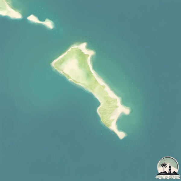
Size: 1.163 km²
Coastline: 6.5 km
Ocean: Indian Ocean
Sea: Indian Ocean
Continent: Oceania
Hauy is a Small Island spanning 1.2 km² with a coastline of 6.5 km.
Archipel: –
Tectonic Plate: Australia – A major tectonic plate covering Australia, New Zealand, and parts of the Indian and Pacific Oceans, known for its relative stability and occasional seismic activity.
The geographic heart of the island is pinpointed at these coordinates:
Latitude: -20.43433343 / Longitude: 116.96701298
Climate and weather of Hauy
Climate Zone: Dry
Climate Details: Hot Deserts Climate
Temperature: Hot
Climate Characteristics: Dominated by extremely hot temperatures, this climate is marked by minimal rainfall and barren landscapes. Nights often experience drastic temperature drops.
Topography and nature of Hauy
Timezone: UTC+08:00
Timezone places: Australia/Perth
Max. Elevation: 7 m
Mean Elevation: 6 m
Vegetation: Shrubland
Tree Coverage: 76%
The mean elevation is 6 m. The highest elevation on the island reaches approximately 7 meters above sea level. The island is characterized by Plains: Flat, low-lying lands characterized by a maximum elevation of up to 200 meters. On islands, plains are typically coastal lowlands or central flat areas.
Dominating Vegetation: Shrubland
Dominated by shrubs and small bushes, these areas are typical in dry, rocky, or sandy environments, as well as in regions with poor soil fertility. Hauy has a tree cover of 76 %.
Vegetation: 1 vegetation zones – Minimal Diversity Island
These islands exhibit the most basic level of ecological diversity, often characterized by a single dominant vegetation type. This could be due to extreme environmental conditions, limited land area, or significant human impact. They represent unique ecosystems where specific species have adapted to thrive in these singular environments.
Infrastructure and Travelling to Hauy
Does the island have a public airport? no.
There is no public and scheduled airport on Hauy. The nearest airport is Karratha Airport, located 37 km away.
Does the island have a major port? no.
There are no major ports on Hauy. The closest major port is PORT WALCOTT, approximately 33 km away.
The mean population of Hauy is 0 per km². Hauy is Uninhabited. The island belongs to Australia.
Continuing your journey, Legendre is the next notable island, situated merely km away.
Hay Island | Darien, CT
Welcome to Hay Island, the ultimate coastal oasis. Breathtaking, unobstructed views of the Long Island Sound stretch from this ...Hay Island | Darien, CT
Welcome to Hay Island, the ultimate coastal oasis. Breathtaking, ...
Welcome to Hay Island, the ultimate coastal oasis. Breathtaking, unobstructed views of the Long Island Sound stretch from this ...
Hay island
Took my Mother and Dog (Freya) out to Hay Island for a walk.
Took my Mother and Dog (Freya) out to Hay Island for a walk.
Cape Hauy, Brunny Island, Tasmania
Tasmanie.
Tasmanie.
CAPE RAOUL, CAPE HAUY & MARIA ISLAND, TASMANIA - 4X4 SPRINTER - AUSTRALIA - NOGRAYDAZE
We're back on the road after a few weeks break working in Derby. We ...
We're back on the road after a few weeks break working in Derby. We head on down to the Tasman Peninsula to hike 2 out of the ...
Hay Island, Darien, CT
HAY ISLAND: Breathtaking, unobstructed views of the Long Island Sound ...
HAY ISLAND: Breathtaking, unobstructed views of the Long Island Sound stretch from this private island at the end of a gated ...
The New Way To Make Hay in Coral Island
In this new video, we're showing you the new way to make hay in Coral ...
In this new video, we're showing you the new way to make hay in Coral Island! With our new way to make hay, you'll be able to ...
Trying To Breed A Fleabitten Friesian (v2)-Wild Horse Islands Roblox
Rate the farm from 1-10 🚜 #shorts #hayday #bananafarm #interestingfarms
Hay Island - 1,600 Acre Private Island - Georgian Bay, Ontario
One of the largest privately held islands on Georgian Bay and is a ...
One of the largest privately held islands on Georgian Bay and is a magnificent sanctuary that provides an idyllic retreat to enjoy ...
The BIGGEST Mistake You're Making in Stardew Valley
Stardew Valley 1.6 is rapidly approaching, and as such, I wanted to ...
Stardew Valley 1.6 is rapidly approaching, and as such, I wanted to focus on some Stardew Valley Tips to help you know all the ...
How To Farm Hay In Coral Island
What you need to do to Make Hay In Coral Island. A Guide and location ...
What you need to do to Make Hay In Coral Island. A Guide and location for Farming Hay on Coral Island A easy way to support the ...
Georgian Bay Adventures Episode 12 - Evening Run to Hay Island on Sea Doo GTX 155
SeaDoo #GeorgianBay #BrucePeninsula #GoPro Episode 12 - Evening Run to ...
SeaDoo #GeorgianBay #BrucePeninsula #GoPro Episode 12 - Evening Run to Hay Island In this episode we head out for an ...
NO HOMESCHOOL IN ICELAND
The people here don't seem to have a problem with this law, but it's ...
The people here don't seem to have a problem with this law, but it's definitely different than our schooling situation in the US ...
Hay Island | Co. Fermanagh | July | 4k
Epic Wubbox Fanmade Hay island lyrics
Ark Resource Locations on The Island! #shorts
ark #arksurvivalevolved #ark2 #pebblehost.
ark #arksurvivalevolved #ark2 #pebblehost.
Good Mirage Island Stock #bloxfruits #roblox
bloxfruits #roblox #english #gaming #shorts.
bloxfruits #roblox #english #gaming #shorts.
เมื่อดูไบ สร้างโลกไว้ขายเศรษฐีกลางทะเล The World Islands 🇦🇪
เมื่อดูไบ สร้างโลกไว้ขายเศรษฐีกลางทะเล The World Islands (For another ...
เมื่อดูไบ สร้างโลกไว้ขายเศรษฐีกลางทะเล The World Islands (For another language subtitle, press CC.)
4 Mẹo Hay Khi Chơi "Allain" Trong Liên Quân Mobile - NTD LQ
4 Mẹo Hay Khi Chơi "Allain" Trong Liên Quân Mobile - NTD LQ liên quân ...
4 Mẹo Hay Khi Chơi "Allain" Trong Liên Quân Mobile - NTD LQ liên quân shorts - shorts liên quân mobile - Liên quân mobile NTD ...
1000 Islands - Hay Island - 6-23-2019
We collecting the hay very early in the morning on this island #shorts
Subscribe for travel videos: ...
Minecraft’s Newest Golem!
Portions of this video are copyrighted and owned by Nintendo, and ...
Portions of this video are copyrighted and owned by Nintendo, and their use is allowed by the Nintendo Game Content Guidelines ...
The Better Way to Farm in Stardew Valley
shorts.
shorts.
101 Raft Tips: #46: Rare Islands
shorts #short #raft #rafttips #tips #tipsandtricks #101 #alidove ...
shorts #short #raft #rafttips #tips #tipsandtricks #101 #alidove #raftgame #rare #secrets #secret #easteregg #eastereggs 101 Raft ...
EPIC AIR WUBBOX SCREAMING! #mysingingmonsters #anime #shorts
Australia is classified as Developed region: nonG7: Developed economies outside of the Group of Seven, characterized by high income and advanced economic structures. The level of income is High income: OECD.
News – Latest Updates and Headlines from Hauy
Stay informed with the most recent news and important headlines from Hauy. Here’s a roundup of the latest developments.
Loading...
Please note: The data used here has been primarily extracted from satellite readings. Deviations from exact values may occur, particularly regarding the height of elevations and population density. Land area and coastline measurements refer to average values at mean high tide.