Hei Ling Chau
Welcome to Hei Ling Chau, a Temperate island in the South China Sea, part of the majestic Pacific Ocean. This guide offers a comprehensive overview of what makes Hei Ling Chau unique – from its geography and climate to its population, infrastructure, and beyond. Dive into the details:
- Geography and Size: Explore the island’s size and location.
- Climate and Weather: Weather patterns and temperature.
- Topography and Nature: Uncover the natural wonders of the island.
- Infrastructure and Travelling: Insights on reaching, staying, and making the most of your visit.
- News and Headlines: Latest News.
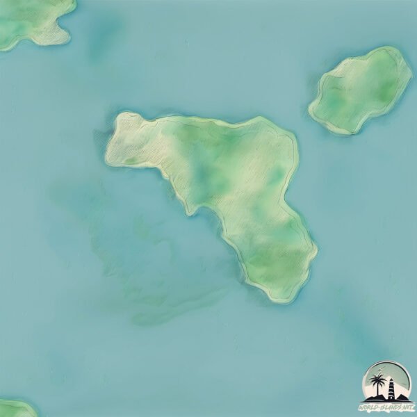
Geography and size of Hei Ling Chau
Size: 2.103 km²
Coastline: 8 km
Ocean: Pacific Ocean
Sea: South China Sea
Continent: Asia
Hei Ling Chau is a Small Island spanning 2.1 km² with a coastline of 8 km.
Archipel: –
Tectonic Plate: Yangtze – A minor tectonic plate in East Asia, often considered a part of the Eurasian Plate. It’s primarily continental and covers the Yangtze River area in China, playing a significant role in the region’s geological stability.
The geographic heart of the island is pinpointed at these coordinates:
Latitude: 22.25187523 / Longitude: 114.03900063
Climate and weather of Hei Ling Chau
Climate Zone: Temperate
Climate Details: Monsoon-Influenced Humid Subtropical Climate
Temperature: Hot Summer
Climate Characteristics: Known for hot, humid summers with significant monsoon rains, contrasted by mild, drier winters.
Topography and nature of Hei Ling Chau
Timezone: UTC+08:00
Timezone places: Australia/Perth
Max. Elevation: 75 m
Mean Elevation: 37 m
Vegetation: Mixed Forest
Tree Coverage: 99%
The mean elevation is 37 m. The highest elevation on the island reaches approximately 75 meters above sea level. The island is characterized by Plains: Flat, low-lying lands characterized by a maximum elevation of up to 200 meters. On islands, plains are typically coastal lowlands or central flat areas.
Dominating Vegetation: Mixed Forest
A combination of both deciduous and evergreen trees, often found in transitional zones between forest types. These forests offer a diverse habitat for various wildlife species. Hei Ling Chau has a tree cover of 99 %.
Vegetation: 4 vegetation zones – Diverse Island
Four distinct vegetation zones mark these islands as ecologically diverse. They might feature varied landscapes such as forests, beaches, grasslands, and rocky areas. Such diversity reflects the island’s complex ecological interactions and varied habitats, which can support a rich array of wildlife and plant species.
Infrastructure and Travelling to Hei Ling Chau
Does the island have a public airport? no.
There is no public and scheduled airport on Hei Ling Chau. The nearest airport is Shun Tak Heliport, located 12 km away.
Does the island have a major port? no.
There are no major ports on Hei Ling Chau. The closest major port is HONG KONG, approximately 17 km away.
The mean population of Hei Ling Chau is 1494 per km². Hei Ling Chau is Densely Populated. The island belongs to China.
Continuing your journey, Lantau Island is the next notable island, situated merely km away.
Hei Ling Chau Island Hongkong #island #ofw #hongkong


China is classified as Emerging region: BRIC: Brazil, Russia, India, and China – Economies noted for their rapid growth and increasing influence on global affairs. The level of income is Upper middle income.
News – Latest Updates and Headlines from Hei Ling Chau
Stay informed with the most recent news and important headlines from Hei Ling Chau. Here’s a roundup of the latest developments.
Please note: The data used here has been primarily extracted from satellite readings. Deviations from exact values may occur, particularly regarding the height of elevations and population density. Land area and coastline measurements refer to average values at mean high tide.