Welcome to Henderson, a Polar island in the South Pacific Ocean, part of the majestic Pacific Ocean. This guide offers a comprehensive overview of what makes Henderson unique – from its geography and climate to its population, infrastructure, and beyond. Dive into the details:
Geography and size of Henderson
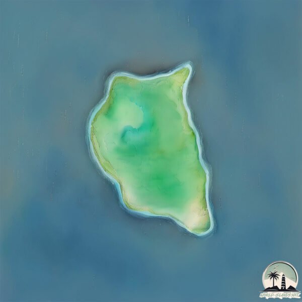
Size: 11.5 km²
Coastline: 46.9 km
Ocean: Pacific Ocean
Sea: South Pacific Ocean
Continent: South America
Henderson is a Medium Island spanning 12 km² with a coastline of 47 km.
Archipel: –
Tectonic Plate: Scotia – Situated in the Southern Ocean, surrounding the Scotia Sea, between South America and Antarctica, known for the Scotia Arc and active seismicity.
The geographic heart of the island is pinpointed at these coordinates:
Latitude: -55.60594777 / Longitude: -69.13759459
Climate and weather of Henderson
Climate Zone: Polar
Climate Details: Tundra
Temperature: Cold
Climate Characteristics: The tundra climate features long, extremely cold winters and short, cool summers. Vegetation is limited to mosses, lichens, and small shrubs due to the low temperatures and short growing seasons. Biodiversity is low, but some specialized species thrive.
Topography and nature of Henderson
Timezone: UTC-04:00
Timezone places: America/La_Paz
Max. Elevation: 230 m
Mean Elevation: 86 m
Vegetation: Shrubland
Tree Coverage: 68%
The mean elevation is 86 m. The highest elevation on the island reaches approximately 230 meters above sea level. The island is characterized by Hills: Gently sloping landforms with rounded tops, having a maximum elevation between 200 and 500 meters. Hills contribute to a varied landscape on islands.
Dominating Vegetation: Shrubland
Dominated by shrubs and small bushes, these areas are typical in dry, rocky, or sandy environments, as well as in regions with poor soil fertility. Henderson has a tree cover of 68 %.
Vegetation: 6 vegetation zones – Very Highly Diverse Island
Islands in this range are ecological powerhouses, showcasing a wide array of vegetation zones. Each zone, from lush rainforests to arid scrublands, coastal mangroves to mountainous regions, contributes to a complex and interdependent ecosystem. These islands are often hotspots of biodiversity, supporting numerous species and intricate ecological processes.
Infrastructure and Travelling to Henderson
Does the island have a public airport? no.
There is no public and scheduled airport on Henderson. The nearest airport is Malvinas Argentinas Airport, located 122 km away.
Does the island have a major port? no.
There are no major ports on Henderson. The closest major port is USHUAIA, approximately 124 km away.
The mean population of Henderson is 0 per km². Henderson is Uninhabited. The island belongs to Chile.
Continuing your journey, Hind is the next notable island, situated merely km away.
Henderson Island - Earth's Hidden Paradise
Explore the remote and pristine beauty of Henderson Island, a UNESCO World Heritage Site, in the heart of the South Pacific.Henderson Island - Earth's Hidden Paradise
Explore the remote and pristine beauty of Henderson Island, a UNESCO ...
Explore the remote and pristine beauty of Henderson Island, a UNESCO World Heritage Site, in the heart of the South Pacific.
The Most Polluted Island that you have never heard about: Henderson Island
Henderson Island is a very remote island in the middle of the South ...
Henderson Island is a very remote island in the middle of the South Pacific, yet, even without a human population or nearby land.
Henderson Island : Remote, unpopulated but most polluted.
Discover the hidden gem of the South Pacific, Henderson Island. From ...
Discover the hidden gem of the South Pacific, Henderson Island. From ancient Polynesian settlements to unique wildlife found ...
Pitcairn Islands – Henderson Island's wildlife
Watch the three-part Britain's Treasure Islands documentary series on ...
Watch the three-part Britain's Treasure Islands documentary series on BBC FOUR, starting Tue 12 Apr 2016 21:00. (repeated Wed ...
Exploring the Untouched Beauty of Henderson Island
Join us on a captivating journey as we explore the untouched beauty of ...
Join us on a captivating journey as we explore the untouched beauty of Henderson Island, a UNESCO World Heritage site in the ...
Pitcairn Island | Henderson Island #island #googleearth
Pitcairn Island is a British Overseas Territory in the Pacific Ocean. ...
Pitcairn Island is a British Overseas Territory in the Pacific Ocean. It's known for being one of the least populated territories in the ...
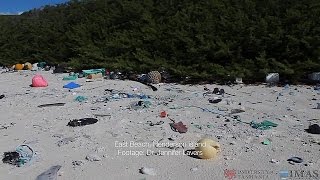
Island's rubbish density 'world's worst' - BBC News
An uninhabited island in the South Pacific is littered with the ...
An uninhabited island in the South Pacific is littered with the highest density of plastic waste anywhere in the world, according to a ...
Henderson Island has nearly 40 million pieces of plastic waste - here's what it's like
Henderson Island - which is one of the most remote places in the world ...
Henderson Island - which is one of the most remote places in the world - is home to nearly 40 million pieces of plastic waste.
Henderson Island
Henderson Island. Henderson Island, which lies in the eastern South ...
Henderson Island. Henderson Island, which lies in the eastern South Pacific, is one of the few atolls in the world whose ecology ...
Henderson Island: Pacific graveyard for plastic pollution
At first sight the scenes could be mistaken for the aftermath of a ...
At first sight the scenes could be mistaken for the aftermath of a teenagers' beach party. It is in fact an uninhabited island, one of ...
Henderson Island has nearly 40 million pieces of plastic waste!
The Pacific island which is 'world's worst polluted'
A tiny, uninhabited island in the middle of the Pacific Ocean, has ...
A tiny, uninhabited island in the middle of the Pacific Ocean, has been found to be one of the most densely polluted areas in the ...
Uninhabited Henderson Island has highest density of man-made debris
The uninhabited Henderson Island, in the South Pacific, is listed as a ...
The uninhabited Henderson Island, in the South Pacific, is listed as a UNESCO World Heritage Site., for its nearly untouched ...
The Henderson Island nowadays…
We hope this video will make you think, good viewing. By: Rafaela, ...
We hope this video will make you think, good viewing. By: Rafaela, Mathilde, Naïma and Mariloup Mcmasterville School of ...
Henderson Island | East Beach - aerial
Earth from Space: Henderson Island
Earth from Space is presented by Kelsea Brennan-Wessels from the ESA ...
Earth from Space is presented by Kelsea Brennan-Wessels from the ESA Web TV virtual studios. Ahead of Earth Day, this edition ...
5 Islands That Shouldn’t Exist #shorts #viral #trending
5 Islands That Shouldn't Exist #explore.
5 Islands That Shouldn't Exist #explore.
Property for Sale in Henderson Island
property for Sale in Henderson Island: A Secluded Paradise in the ...
property for Sale in Henderson Island: A Secluded Paradise in the South Pacific Nestled in the South Pacific, Henderson Island is ...
Henderson Island: One of Nature's Untouched Gems
Henderson Island is a remote and uninhabited coral atoll located in ...
Henderson Island is a remote and uninhabited coral atoll located in the eastern South Pacific, part of the Pitcairn Islands group.
Henderson Island Trip
My trip to Henderson Island - June 2024.
My trip to Henderson Island - June 2024.
Uninhabited South Pacific island turning into garbage dump
Henderson Island, part of the Pitcairn group, is polluted with the ...
Henderson Island, part of the Pitcairn group, is polluted with the highest density of plastic debris ever reported, with thousands of ...
Henderson Island 🇵🇳🇵🇳 | Densest Plastic Pollution in the world | Pitcairn vlogger 🇵🇳
Henderson Island is one of four islands that make up the Pitcairn ...
Henderson Island is one of four islands that make up the Pitcairn Islands. It is uninhabited and home to the highest density of ...
Henderson Island's BEST Kept Secret Revealed
Henderson Island's BEST Kept Secret Revealed Discover the remote ...
Henderson Island's BEST Kept Secret Revealed Discover the remote beauty of Henderson Island, a unique coral atoll in the ...
Ocean pollution: Remote, uninhabited Henderson Island is covered in our garbage - TomoNews
PITCAIRN ISLANDS, SOUTH PACIFIC OCEAN — One of the most isolated and ...
PITCAIRN ISLANDS, SOUTH PACIFIC OCEAN — One of the most isolated and inaccessible islands on the planet is covered in ...
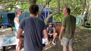
Henderson Island Clean up expedition
James Beard, Recycling Services Manager at Valpak Ltd and all round ...
James Beard, Recycling Services Manager at Valpak Ltd and all round great guy is joining an elite team in cleaning up one of the ...
Chile is classified as Emerging region: G20: Group of Twenty – Major economies comprising both developed and emerging countries, representing the world’s largest economies. The level of income is Upper middle income.
News – Latest Updates and Headlines from Henderson
Stay informed with the most recent news and important headlines from Henderson. Here’s a roundup of the latest developments.
Loading...
Please note: The data used here has been primarily extracted from satellite readings. Deviations from exact values may occur, particularly regarding the height of elevations and population density. Land area and coastline measurements refer to average values at mean high tide.