Hinchinbrook-317543
Welcome to Hinchinbrook, a Tropical island in the Coral Sea, part of the majestic Pacific Ocean. This guide offers a comprehensive overview of what makes Hinchinbrook unique – from its geography and climate to its population, infrastructure, and beyond. Dive into the details:
- Geography and Size: Explore the island’s size and location.
- Climate and Weather: Weather patterns and temperature.
- Topography and Nature: Uncover the natural wonders of the island.
- Infrastructure and Travelling: Insights on reaching, staying, and making the most of your visit.
- News and Headlines: Latest News.
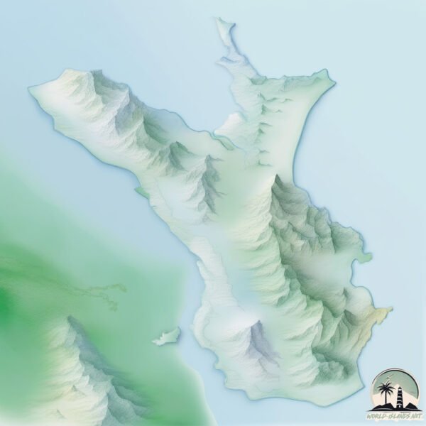
Geography and size of Hinchinbrook
Size: 392.7 km²
Coastline: 250.6 km
Ocean: Pacific Ocean
Sea: Coral Sea
Continent: Oceania
Hinchinbrook is a Large Island spanning 393 km² with a coastline of 251 km.
Archipel: –
Tectonic Plate: Australia – A major tectonic plate covering Australia, New Zealand, and parts of the Indian and Pacific Oceans, known for its relative stability and occasional seismic activity.
The geographic heart of the island is pinpointed at these coordinates:
Latitude: -18.35607461 / Longitude: 146.23643403
Climate and weather of Hinchinbrook
Climate Zone: Tropical
Climate Details: Tropical Monsoon Climate
Temperature: Hot
Climate Characteristics: Characterized by heavy rainfall, high humidity, and uniformly high temperatures, but with a distinct short dry season. It features a seasonal reversal of prevailing wind directions.
Topography and nature of Hinchinbrook
Timezone: UTC+10:00
Timezone places: Australia/Sydney
Max. Elevation: 924 m
Mean Elevation: 170 m
Vegetation: Evergreen Broadleaf Forest
Tree Coverage: 87%
The mean elevation is 170 m. The highest elevation on the island reaches approximately 924 meters above sea level. The island is characterized by Plateau: Elevated flatlands rising sharply above the surrounding area, with a maximum elevation over 500 meters but a mean elevation less than 300 meters, forming unique highland areas on islands.
Dominating Vegetation: Evergreen Broadleaf Forest
Characterized by dense, lush canopies of broadleaf trees that retain their leaves year-round. These forests are typically found in tropical and subtropical regions and are known for their high biodiversity. Hinchinbrook has a tree cover of 87 %.
Vegetation: 7 vegetation zones – Very Highly Diverse Island
Islands in this range are ecological powerhouses, showcasing a wide array of vegetation zones. Each zone, from lush rainforests to arid scrublands, coastal mangroves to mountainous regions, contributes to a complex and interdependent ecosystem. These islands are often hotspots of biodiversity, supporting numerous species and intricate ecological processes.
Infrastructure and Travelling to Hinchinbrook
Does the island have a public airport? no.
There is no public and scheduled airport on Hinchinbrook. The nearest airport is Palm Island Airport, located 41 km away.
Does the island have a major port? no.
There are no major ports on Hinchinbrook. The closest major port is LUCINDA, approximately 4 km away.
The mean population of Hinchinbrook is 0 per km². Hinchinbrook is Uninhabited. The island belongs to Australia.
Continuing your journey, Orpheus is the next notable island, situated merely km away.
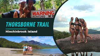
Girls take on Croc Country | BEST hiking Australia | Thorsborne Trail HINCHINBROOK ISLAND

Australia is classified as Developed region: nonG7: Developed economies outside of the Group of Seven, characterized by high income and advanced economic structures. The level of income is High income: OECD.
News – Latest Updates and Headlines from Hinchinbrook
Stay informed with the most recent news and important headlines from Hinchinbrook. Here’s a roundup of the latest developments.
Please note: The data used here has been primarily extracted from satellite readings. Deviations from exact values may occur, particularly regarding the height of elevations and population density. Land area and coastline measurements refer to average values at mean high tide.