Hispaniola
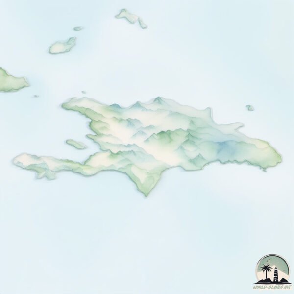
Welcome to Hispaniola, a Tropical island in the Caribbean Sea, part of the majestic Atlantic Ocean. This guide offers a comprehensive overview of what makes Hispaniola unique – from its geography and climate to its population, infrastructure, and beyond. Dive into the details:
- Geography and Size: Explore the island’s size and location.
- Climate and Weather: Weather patterns and temperature.
- Topography and Nature: Uncover the natural wonders of the island.
- Infrastructure and Travelling: Insights on reaching, staying, and making the most of your visit.
- News and Headlines: Latest News.
Geography and size of Hispaniola
Size: 74366 km²
Coastline: 3324 km
Ocean: Atlantic Ocean
Sea: Caribbean Sea
Continent: North America
Hispaniola is a Giant Island spanning 74366 km² with a coastline of 3324 km.
Archipel: Greater Antilles – A major island group in the Caribbean, including Cuba, Jamaica, Hispaniola, and Puerto Rico, known for their rich history and diverse cultures.
Tectonic Plate: Caribbean – Covering the Caribbean Sea and surrounding regions, this plate is bordered by the North American Plate and the South American Plate. Known for seismic activity, including earthquakes and volcanic eruptions, and features like the Puerto Rico Trench.
The geographic heart of the island is pinpointed at these coordinates:
Latitude: 18.91076779 / Longitude: -71.26191891
Climate and weather of Hispaniola
Climate Zone: Tropical
Climate Details: Tropical Savanna, Wet
Temperature: Hot
Climate Characteristics: Defined by distinct wet and dry seasons with high temperatures year-round. Pronounced rainfall occurs during the wet season, while the dry season is marked by drought.
Topography and nature of Hispaniola
Timezone: UTC-05:00
Timezone places: America/New_York
Max. Elevation: 3098 m Pico Duarte
Mean Elevation: 407 m
Vegetation: Agricultural Mosaic
Tree Coverage: 31%
The mean elevation is 407 m. Dominating the island’s landscape, the majestic “Pico Duarte” rises as the highest peak, soaring to impressive heights. The island is characterized by Mountains: High, steeply elevated landforms. Characterized by both a high maximum elevation (over 500 meters) and a high mean elevation, creating rugged, mountainous terrains on islands.
Dominating Vegetation: Agricultural Mosaic
A mix of cropland and natural vegetation, often seen in rural landscapes where agricultural fields are interspersed with patches of natural habitats. Hispaniola has a tree cover of 31 %.
Vegetation: 19 vegetation zones – Exceptionally Diverse Island
Islands with more than ten vegetation zones are among the most ecologically rich and varied in the world. These islands are akin to miniature continents, boasting an incredible array of ecosystems. The sheer range of habitats, from high peaks to deep valleys, rainforests to deserts, creates a mosaic of life that is unparalleled. They are crucial for conservation and ecological studies.
Infrastructure and Travelling to Hispaniola
Does the island have a public airport? yes.
Hispaniola has a public and scheduled airport. The following airports are located on this island: Maria Montez International Airport, Samaná El Catey International Airport, La Isabela International Airport, Los Llanos de Sabanatosa Airport, Casa De Campo International Airport, Punta Cana International Airport, Gregorio Luperon International Airport, Las Américas International Airport, Cibao International Airport, Les Cayes Airport, Cap Haitien International Airport, Jacmel Airport, Jérémie Airport, Toussaint Louverture International Airport.
Does the island have a major port? yes.
Hispaniola is home to a major port. The following ports are situated on the island: CABO ROJO, JACMEL, PETIT GOAVE, PORT AU PRINCE, PEPILLO SALCEDO, CAP HAITIEN, SANCHEZ, LA ROMANA, SAN PEDRO DE MACORIS, ANDRES (ANDRES LNG TERMINAL), PUERTO VIEJO DE AZUA.
The mean population of Hispaniola is 354 per km². Hispaniola is Moderately Inhabited. The island belongs to Dominican Republic.
The name of the island resonates across different cultures and languages. Here is how it is known around the world: Arabic: هيسبانيولا; German: Hispaniola; Spanish: La Española; French: Hispaniola; Portuguese: Ilha de São Domingos; Russian: Гаити; Chinese: 伊斯帕尼奥拉岛
Continuing your journey, Grande Cayemite is the next notable island, situated merely km away.
Why did Haiti and the Dominican Republic Break Up? (Short Animated Documentary)

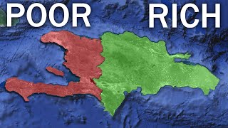
Dominican Republic is classified as Developing region: Regions characterized by lower income levels, with economies in the process of industrialization and modernization. The level of income is Upper middle income.
News – Latest Updates and Headlines from Hispaniola
Stay informed with the most recent news and important headlines from Hispaniola. Here’s a roundup of the latest developments.
Social Media Posts about Hispaniola
Please note: The data used here has been primarily extracted from satellite readings. Deviations from exact values may occur, particularly regarding the height of elevations and population density. Land area and coastline measurements refer to average values at mean high tide.