Hoandehdhoo
Welcome to Hoandehdhoo, a Tropical island in the Laccadive Sea, part of the majestic Indian Ocean. This guide offers a comprehensive overview of what makes Hoandehdhoo unique – from its geography and climate to its population, infrastructure, and beyond. Dive into the details:
- Geography and Size: Explore the island’s size and location.
- Climate and Weather: Weather patterns and temperature.
- Topography and Nature: Uncover the natural wonders of the island.
- Infrastructure and Travelling: Insights on reaching, staying, and making the most of your visit.
- News and Headlines: Latest News.
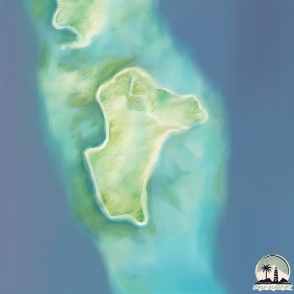
Geography and size of Hoandehdhoo
Size: 1.079 km²
Coastline: 7.3 km
Ocean: Indian Ocean
Sea: Laccadive Sea
Continent: Seven seas (open ocean)
Hoandehdhoo is a Small Island spanning 1.1 km² with a coastline of 7.3 km.
Archipel: Maldive Islands – A tropical paradise in the Indian Ocean, known for their stunning coral reefs, diverse marine life, and luxury resorts.
Tectonic Plate: Pacific – The world’s largest tectonic plate, covering much of the Pacific Ocean, known for the Pacific Ring of Fire with extensive seismic and volcanic activity.
The geographic heart of the island is pinpointed at these coordinates:
Latitude: 0.44497435 / Longitude: 73.00358062
Climate and weather of Hoandehdhoo
Climate Zone: Tropical
Climate Details: Tropical Monsoon Climate
Temperature: Hot
Climate Characteristics: Characterized by heavy rainfall, high humidity, and uniformly high temperatures, but with a distinct short dry season. It features a seasonal reversal of prevailing wind directions.
Topography and nature of Hoandehdhoo
Timezone: UTC+05:00
Timezone places: Asia/Karachi
Max. Elevation: 5 m
Mean Elevation: -2 m
Vegetation: Evergreen Broadleaf Forest
Tree Coverage: 29%
The mean elevation is -2 m. The highest elevation on the island reaches approximately 5 meters above sea level. The island is characterized by Plains: Flat, low-lying lands characterized by a maximum elevation of up to 200 meters. On islands, plains are typically coastal lowlands or central flat areas.
Dominating Vegetation: Evergreen Broadleaf Forest
Characterized by dense, lush canopies of broadleaf trees that retain their leaves year-round. These forests are typically found in tropical and subtropical regions and are known for their high biodiversity. Hoandehdhoo has a tree cover of 29 %.
Vegetation: 2 vegetation zones – Low Diversity Island
Islands with two distinct vegetation zones offer slightly more ecological variety. These zones could be due to differences in elevation, moisture, or other environmental factors. While still limited in biodiversity, these islands may offer a contrast between the two zones, such as a coastline with mangroves and an inland area with grassland.
Infrastructure and Travelling to Hoandehdhoo
Does the island have a public airport? no.
There is no public and scheduled airport on Hoandehdhoo. The nearest airport is Kaadedhdhoo Airport, located 4 km away.
Does the island have a major port? no.
There are no major ports on Hoandehdhoo. The closest major port is MALE, approximately 416 km away.
The mean population of Hoandehdhoo is 1044 per km². Hoandehdhoo is Densely Populated. The island belongs to Maldives.
Continuing your journey, Vypīn Island is the next notable island, situated merely km away.
The President meets with the residential community of Hoandehdhoo Island


Maldives is classified as Developing region: Regions characterized by lower income levels, with economies in the process of industrialization and modernization. The level of income is Upper middle income.
News – Latest Updates and Headlines from Hoandehdhoo
Stay informed with the most recent news and important headlines from Hoandehdhoo. Here’s a roundup of the latest developments.
Please note: The data used here has been primarily extracted from satellite readings. Deviations from exact values may occur, particularly regarding the height of elevations and population density. Land area and coastline measurements refer to average values at mean high tide.