Hòn Chà Là
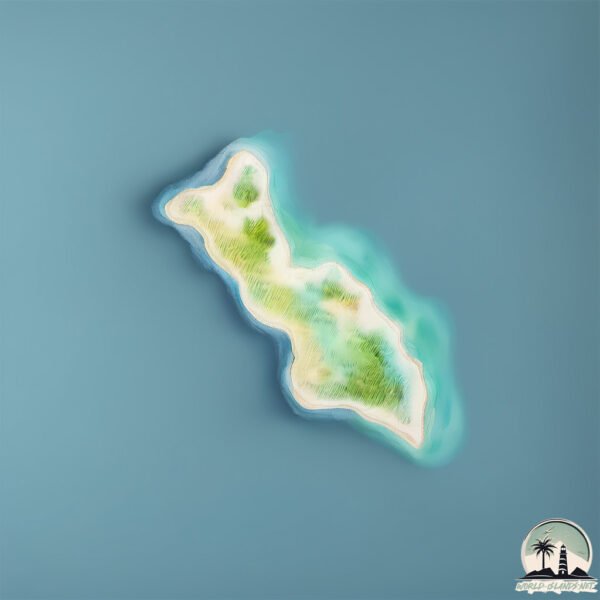
Welcome to Hòn Chà Là, a Tropical island in the South China Sea, part of the majestic Pacific Ocean. This guide offers a comprehensive overview of what makes Hòn Chà Là unique – from its geography and climate to its population, infrastructure, and beyond. Dive into the details:
- Geography and Size: Explore the island’s size and location.
- Climate and Weather: Weather patterns and temperature.
- Topography and Nature: Uncover the natural wonders of the island.
- Infrastructure and Travelling: Insights on reaching, staying, and making the most of your visit.
- News and Headlines: Latest News.
Geography and size of Hòn Chà Là
Size: 0.765 km²
Coastline: 5 km
Ocean: Pacific Ocean
Sea: South China Sea
Continent: Asia
Hòn Chà Là is a Tiny Island spanning 0.765 km² with a coastline of 5 km.
Archipel: –
Tectonic Plate: Sunda – Extends across Southeast Asia, encompassing parts of the Sunda Shelf, known for its interaction with the Australian Plate, contributing to volcanic activity in Indonesia.
The geographic heart of the island is pinpointed at these coordinates:
Latitude: 12.36244154 / Longitude: 109.37470478
Climate and weather of Hòn Chà Là
Climate Zone: Tropical
Climate Details: Tropical Savanna, Wet
Temperature: Hot
Climate Characteristics: Defined by distinct wet and dry seasons with high temperatures year-round. Pronounced rainfall occurs during the wet season, while the dry season is marked by drought.
Topography and nature of Hòn Chà Là
Timezone: UTC+07:00
Timezone places: Asia/Jakarta
Max. Elevation: 19 m
Mean Elevation: 12 m
Vegetation: Agricultural Mosaic
Tree Coverage: 83%
The mean elevation is 12 m. The highest elevation on the island reaches approximately 19 meters above sea level. The island is characterized by Plains: Flat, low-lying lands characterized by a maximum elevation of up to 200 meters. On islands, plains are typically coastal lowlands or central flat areas.
Dominating Vegetation: Agricultural Mosaic
A mix of cropland and natural vegetation, often seen in rural landscapes where agricultural fields are interspersed with patches of natural habitats. Hòn Chà Là has a tree cover of 83 %.
Vegetation: 2 vegetation zones – Low Diversity Island
Islands with two distinct vegetation zones offer slightly more ecological variety. These zones could be due to differences in elevation, moisture, or other environmental factors. While still limited in biodiversity, these islands may offer a contrast between the two zones, such as a coastline with mangroves and an inland area with grassland.
Infrastructure and Travelling to Hòn Chà Là
Does the island have a public airport? no.
There is no public and scheduled airport on Hòn Chà Là. The nearest airport is Cam Ranh International Airport / Cam Ranh Air Base, located 44 km away.
Does the island have a major port? no.
There are no major ports on Hòn Chà Là. The closest major port is NHA TRANG, approximately 20 km away.
The mean population of Hòn Chà Là is 239 per km². Hòn Chà Là is Moderately Inhabited. The island belongs to Vietnam.
Continuing your journey, Hòn Tre is the next notable island, situated merely km away.
This Tiny Village Is Hanging on a Volcanic Mountain


![[P.2] Phát hiện con rắn khổng lồ và sự thật khó tin #shorts](https://i.ytimg.com/vi/fgdmo3SpM7s/mqdefault.jpg)


Vietnam is classified as Emerging region: G20: Group of Twenty – Major economies comprising both developed and emerging countries, representing the world’s largest economies. The level of income is Lower middle income.
News – Latest Updates and Headlines from Hòn Chà Là
Stay informed with the most recent news and important headlines from Hòn Chà Là. Here’s a roundup of the latest developments.
Please note: The data used here has been primarily extracted from satellite readings. Deviations from exact values may occur, particularly regarding the height of elevations and population density. Land area and coastline measurements refer to average values at mean high tide.