Welcome to Hòn Dung, a Tropical island in the South China Sea, part of the majestic Pacific Ocean. This guide offers a comprehensive overview of what makes Hòn Dung unique – from its geography and climate to its population, infrastructure, and beyond. Dive into the details:
Geography and size of Hòn Dung
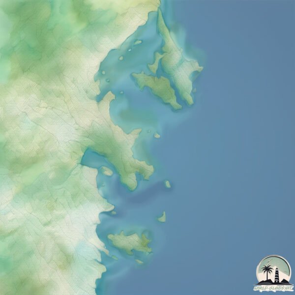
Size: 0.441 km²
Coastline: 2.5 km
Ocean: Pacific Ocean
Sea: South China Sea
Continent: Asia
Hòn Dung is a Tiny Island spanning 0.441 km² with a coastline of 2.5 km.
Archipel: –
Tectonic Plate: Sunda – Extends across Southeast Asia, encompassing parts of the Sunda Shelf, known for its interaction with the Australian Plate, contributing to volcanic activity in Indonesia.
The geographic heart of the island is pinpointed at these coordinates:
Latitude: 12.34024216 / Longitude: 109.34833082
Climate and weather of Hòn Dung
Climate Zone: Tropical
Climate Details: Tropical Savanna, Wet
Temperature: Hot
Climate Characteristics: Defined by distinct wet and dry seasons with high temperatures year-round. Pronounced rainfall occurs during the wet season, while the dry season is marked by drought.
Topography and nature of Hòn Dung
Timezone: UTC+07:00
Timezone places: Asia/Jakarta
Max. Elevation: 36 m
Mean Elevation: 17 m
Vegetation: Evergreen Broadleaf Forest
Tree Coverage: 78%
The mean elevation is 17 m. The highest elevation on the island reaches approximately 36 meters above sea level. The island is characterized by Plains: Flat, low-lying lands characterized by a maximum elevation of up to 200 meters. On islands, plains are typically coastal lowlands or central flat areas.
Dominating Vegetation: Evergreen Broadleaf Forest
Characterized by dense, lush canopies of broadleaf trees that retain their leaves year-round. These forests are typically found in tropical and subtropical regions and are known for their high biodiversity. Hòn Dung has a tree cover of 78 %.
Vegetation: 1 vegetation zones – Minimal Diversity Island
These islands exhibit the most basic level of ecological diversity, often characterized by a single dominant vegetation type. This could be due to extreme environmental conditions, limited land area, or significant human impact. They represent unique ecosystems where specific species have adapted to thrive in these singular environments.
Infrastructure and Travelling to Hòn Dung
Does the island have a public airport? no.
There is no public and scheduled airport on Hòn Dung. The nearest airport is Cam Ranh International Airport / Cam Ranh Air Base, located 34 km away.
Does the island have a major port? no.
There are no major ports on Hòn Dung. The closest major port is NHA TRANG, approximately 14 km away.
The mean population of Hòn Dung is 1025 per km². Hòn Dung is Densely Populated. The island belongs to Vietnam.
Continuing your journey, Hòn Lớn is the next notable island, situated merely km away.
Sinh Tồn Ở Kalimantan – Hòn Đảo Lớn Nhất Châu Á
thuthachsinhton #reviewsinhton #sinhton Chào mừng đến với Lê Minh IT – Hành Trình Sinh Tồn Đích Thực! Bạn đang theo ...Sinh Tồn Ở Kalimantan – Hòn Đảo Lớn Nhất Châu Á
thuthachsinhton #reviewsinhton #sinhton Chào mừng đến với Lê Minh IT – ...
thuthachsinhton #reviewsinhton #sinhton Chào mừng đến với Lê Minh IT – Hành Trình Sinh Tồn Đích Thực! Bạn đang theo ...
HÒN YẾN: Ngỡ Ngàng Món Ăn Quá Rẻ | Bình Minh Làng Biển Đảo
Chào mừng quí vị đến với kênh Nha Trang Biển Xanh. Kênh youtube giới ...
Chào mừng quí vị đến với kênh Nha Trang Biển Xanh. Kênh youtube giới thiệu về đời sống, văn hóa, ẩm thực và những hoạt ...
ĐẢO CỌ DUBAI: KỲ QUAN THỨ 8 CỦA THẾ GIỚI
BlvHaiThanh #BLVHảiThanh #BLVhaiThanhStory #Dubai #ĐảoCọ ĐẢO CỌ DUBAI: ...
BlvHaiThanh #BLVHảiThanh #BLVhaiThanhStory #Dubai #ĐảoCọ ĐẢO CỌ DUBAI: KỲ QUAN THỨ 8 CỦA THẾ GIỚI Đăng ký ...
Hòn Khoai (Cà Mau) được định hướng trở thành đảo di sản | THƯ VIỆN PHÁP LUẬT
TVPL #ThuVienPhapLuat #Honkhoai THƯ VIỆN PHÁP LUẬT - MEDIA TEAM Nội ...
TVPL #ThuVienPhapLuat #Honkhoai THƯ VIỆN PHÁP LUẬT - MEDIA TEAM Nội dung: Anh Hào Trình bày: Đức Huy Dựng hình: ...
Hòn đảo nguy hiểm nhất thế giới? #shorts
Hòn đảo nguy hiểm nhất thế giới? #shorts ...
Hòn đảo nguy hiểm nhất thế giới? #shorts ------------------------------------ Lê Hoàng Việt | AI & Video Business Fanpage: ...
Review phim: Island - Hòn Đảo Ma Quái full || Cha Eun Woo, Kim NamGil, Lee DaHee, và Sung Joon
Chúc cả nhà xem video vui vẻ Review phim: Hòn Đảo Ma Quái Bản Full - ...
Chúc cả nhà xem video vui vẻ Review phim: Hòn Đảo Ma Quái Bản Full - Tóm Tắt Phim Island 2022 nội dung : Hòn Đảo Ma Quái ...
Nhật Bản Thả 8 CON THỎ THÍ NGHIỆM Lên ĐẢO KHÍ ĐỘC – 40 Năm Sau Cả Thế Giới Hoảng Hốt!
Từ một hòn đảo từng sản xuất hơn sáu nghìn tấn khí độc đến “thiên ...
Từ một hòn đảo từng sản xuất hơn sáu nghìn tấn khí độc đến “thiên đường thỏ” với hơn một nghìn cá thể, câu chuyện này ẩn ...
Hòn đảo búp bê bị ám | Điều thú vị có thể bạn chưa biết | Davo's Lingo #shorts
Đây là kênh Youtube chính thức của Davo's Lingo.
Đây là kênh Youtube chính thức của Davo's Lingo.
Hòn đảo duy nhất Việt Nam có hai ngọn núi lửa đã tắt, tuổi đời hàng chục triệu năm
Đảo Lý Sơn, nằm ở Quảng Ngãi, nổi tiếng với vẻ đẹp hoang sơ, bãi biển ...
Đảo Lý Sơn, nằm ở Quảng Ngãi, nổi tiếng với vẻ đẹp hoang sơ, bãi biển trong xanh, di sản văn hóa và lịch sử đặc sắc.
Hòn đảo tách biệt với thế giới? #shorts #island
Hòn đảo tách biệt với thế giới? #shorts #island #shortvideo #fyp ...
Hòn đảo tách biệt với thế giới? #shorts #island #shortvideo #fyp ------------------------------------ Lê Hoàng Việt | AI & Video Business ...
TẠI SAO ĐẢO PHÚ QUỐC KHÔNG THUỘC VỀ CAMPUCHIA? #khamphathegioi #shorts #campuchia #cambodia #phuquoc
Tại sao đảo Phú Quốc – hòn đảo lớn nhất Việt Nam – lại không thuộc về ...
Tại sao đảo Phú Quốc – hòn đảo lớn nhất Việt Nam – lại không thuộc về Campuchia, dù chỉ cách bờ biển nước này vỏn vẹn 12 ...
Tỷ Phú Sở Hữu Hòn Đảo Lanai - Kỳ Quan Thiên Nhiên Xa Hoa Nhất Hawaii | Giới Thượng Lưu
Tỷ Phú Sở Hữu Hòn Đảo Lanai - Kỳ Quan Thiên Nhiên Xa Hoa Nhất Hawaii | ...
Tỷ Phú Sở Hữu Hòn Đảo Lanai - Kỳ Quan Thiên Nhiên Xa Hoa Nhất Hawaii | Giới Thượng Lưu Một tỷ phú sở hữu hòn đảo Lanai ...
TẠI SAO ĐÀI LOAN LẠI KIỂM SOÁT HÒN ĐẢO LỚN NHẤT Ở QUẦN ĐẢO TRƯỜNG SA CỦA VIỆT NAM? #khamphathegioi
Các bạn đang xem video: ▷TẠI SAO ĐÀI LOAN LẠI KIỂM SOÁT HÒN ĐẢO LỚN ...
Các bạn đang xem video: ▷TẠI SAO ĐÀI LOAN LẠI KIỂM SOÁT HÒN ĐẢO LỚN NHẤT Ở QUẦN ĐẢO TRƯỜNG SA CỦA VIỆT ...
Hòn Đảo Rác Siêu Lớn Ở Giữa Thái Bình Dương. Gấp 3 Lần Việt Nam! #khamphathegioi #shorts #bando #usa
Các bạn đang xem video: ▷Hòn Đảo Rác Siêu Lớn Ở Giữa Thái Bình Dương. ...
Các bạn đang xem video: ▷Hòn Đảo Rác Siêu Lớn Ở Giữa Thái Bình Dương. Gấp 3 Lần Việt Nam! “Bản Đồ Ngắn” là Kênh cung ...
Ramree - Hòn đảo nguy hiểm nhất thế giới
Ramree - Hòn đảo nguy hiểm nhất thế giới #shorts #shortvideo #facts ...
Ramree - Hòn đảo nguy hiểm nhất thế giới #shorts #shortvideo #facts #khampha #video #viralvideo #fypyoutube ...
Last chance to see this island? Liệu khi nào hòn đảo này sụp đổ? #subscribe
travel #travelling #traveling #dulich #dulichvietnam #halong ...
travel #travelling #traveling #dulich #dulichvietnam #halong #halongbay #island #islands.
Khi Hòn Đảo Squid Game Có Thật | Sheep #shorts
Tóc Húi Cua Chế Tạo Sung Bắn Cá Hoang Dã #tóchúicua #tochuicua #sinhton
SERIES 1 - FULL: Tóc Húi Cua Thử Thách Sinh Tồn Đảo Hoang King Lee - ...
SERIES 1 - FULL: Tóc Húi Cua Thử Thách Sinh Tồn Đảo Hoang King Lee - Indonesia Đầy Hải Sản Đừng quên like, share, đăng ...
Hòn đảo duy nhất không có khái niệm thời gian | Kiến thức thú vị có thể bạn chưa biết
Follow me! Thêm một điều thú vị! Thêm một kiến thức mới! ▻ Mình hi ...
Follow me! Thêm một điều thú vị! Thêm một kiến thức mới! ▻ Mình hi vọng đây là nơi mọi người có thể giải trí, tiếp nhận thông tin, ...
🔱Hòn đảo kì lạ #Shorts
Hòn đảo kì lạ #kìlạ #khampha #vidiệuchannel Kết nối với mình nhé : ...
Hòn đảo kì lạ #kìlạ #khampha #vidiệuchannel Kết nối với mình nhé : Fanpage: ...
Những hòn đảo bạn nên tránh xa | Những câu chuyện thú vị có thể bạn chưa biết (p28) #Shorts
Bí ẩn: Hòn đảo tự di chuyển ở Canada
Bí ẩn: Hòn đảo tự di chuyển ở Canada ---------------------- Công ty Cổ ...
Bí ẩn: Hòn đảo tự di chuyển ở Canada ---------------------- Công ty Cổ phần Truyền thông và Ứng dụng công nghệ thông tin FBNC ...
Hòn Đảo Dành Cho Giới Siêu Giàu Sẽ Trông Như Thế Nào?
Ốc đảo Fisher nằm ngoài khơi bờ biển Miami được mệnh danh là một trong ...
Ốc đảo Fisher nằm ngoài khơi bờ biển Miami được mệnh danh là một trong những địa điểm tụ hội của các triệu phú giàu có bậc ...
Sân bay kỳ lạ trên hòn đảo nhỏ #shorts #shortvideo #review
Sân bay kỳ lạ trên hòn đảo nhỏ #shorts #shortvideo #review.
Sân bay kỳ lạ trên hòn đảo nhỏ #shorts #shortvideo #review.
hòn đảo mà cho tiền bạn cũng không bao giờ đến
Kênh Youtube chính thức của td comics. Mọi người subscribe đón xem ...
Kênh Youtube chính thức của td comics. Mọi người subscribe đón xem video nhé! Mình sẽ làm về khoa học, vũ trụ, người ngoài ...
Vietnam is classified as Emerging region: G20: Group of Twenty – Major economies comprising both developed and emerging countries, representing the world’s largest economies. The level of income is Lower middle income.
News – Latest Updates and Headlines from Hòn Dung
Stay informed with the most recent news and important headlines from Hòn Dung. Here’s a roundup of the latest developments.
Loading...
Please note: The data used here has been primarily extracted from satellite readings. Deviations from exact values may occur, particularly regarding the height of elevations and population density. Land area and coastline measurements refer to average values at mean high tide.