Hòn Sơn Chà
Welcome to Hòn Sơn Chà, a Tropical island in the South China Sea, part of the majestic Pacific Ocean. This guide offers a comprehensive overview of what makes Hòn Sơn Chà unique – from its geography and climate to its population, infrastructure, and beyond. Dive into the details:
- Geography and Size: Explore the island’s size and location.
- Climate and Weather: Weather patterns and temperature.
- Topography and Nature: Uncover the natural wonders of the island.
- Infrastructure and Travelling: Insights on reaching, staying, and making the most of your visit.
- News and Headlines: Latest News.
Geography and size of Hòn Sơn Chà
Size: 1.598 km²
Coastline: 5.4 km
Ocean: Pacific Ocean
Sea: South China Sea
Continent: Asia
Hòn Sơn Chà is a Small Island spanning 1.6 km² with a coastline of 5.4 km.
Archipel: –
Tectonic Plate: India – A major tectonic plate that initially moved northward at a rapid pace before colliding with the Eurasian Plate. This collision is responsible for the uplift of the Himalayas and the Tibetan Plateau.
The geographic heart of the island is pinpointed at these coordinates:
Latitude: 16.21778156 / Longitude: 108.20482791
Climate and weather of Hòn Sơn Chà
Climate Zone: Tropical
Climate Details: Tropical Monsoon Climate
Temperature: Hot
Climate Characteristics: Characterized by heavy rainfall, high humidity, and uniformly high temperatures, but with a distinct short dry season. It features a seasonal reversal of prevailing wind directions.
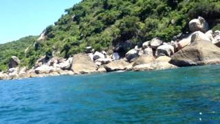
Topography and nature of Hòn Sơn Chà
Timezone: UTC+07:00
Timezone places: Asia/Jakarta
Max. Elevation: 106 m
Mean Elevation: 82 m
Vegetation: Evergreen Broadleaf Forest
Tree Coverage: 76%
The mean elevation is 82 m. The highest elevation on the island reaches approximately 106 meters above sea level. The island is characterized by Plains: Flat, low-lying lands characterized by a maximum elevation of up to 200 meters. On islands, plains are typically coastal lowlands or central flat areas.
Dominating Vegetation: Evergreen Broadleaf Forest
Characterized by dense, lush canopies of broadleaf trees that retain their leaves year-round. These forests are typically found in tropical and subtropical regions and are known for their high biodiversity. Hòn Sơn Chà has a tree cover of 76 %.
Vegetation: 5 vegetation zones – Highly Diverse Island
With five different vegetation zones, these islands offer a rich tapestry of ecosystems. The variety could include dense forests, open meadows, wetlands, coastal zones, and more. This level of diversity supports an intricate web of life, with each zone playing a vital role in the overall ecological health and balance of the island.
Infrastructure and Travelling to Hòn Sơn Chà
Does the island have a public airport? no.
There is no public and scheduled airport on Hòn Sơn Chà. The nearest airport is Da Nang International Airport, located 18 km away.
Does the island have a major port? no.
There are no major ports on Hòn Sơn Chà. The closest major port is DA NANG, approximately 12 km away.
The mean population of Hòn Sơn Chà is 2098 per km². Hòn Sơn Chà is Densely Populated. The island belongs to Vietnam.
Continuing your journey, Cù Lao Chàm is the next notable island, situated merely km away.
Khám phá Hòn Sơn Chà - Đảo ngọc xứ Huế - Biển Việt Nam - Minh Nhà Đất


Vietnam is classified as Emerging region: G20: Group of Twenty – Major economies comprising both developed and emerging countries, representing the world’s largest economies. The level of income is Lower middle income.
News – Latest Updates and Headlines from Hòn Sơn Chà
Stay informed with the most recent news and important headlines from Hòn Sơn Chà. Here’s a roundup of the latest developments.
Please note: The data used here has been primarily extracted from satellite readings. Deviations from exact values may occur, particularly regarding the height of elevations and population density. Land area and coastline measurements refer to average values at mean high tide.