Horoatera
Welcome to Horoatera, a Tropical island in the South Pacific Ocean, part of the majestic Pacific Ocean. This guide offers a comprehensive overview of what makes Horoatera unique – from its geography and climate to its population, infrastructure, and beyond. Dive into the details:
- Geography and Size: Explore the island’s size and location.
- Climate and Weather: Weather patterns and temperature.
- Topography and Nature: Uncover the natural wonders of the island.
- Infrastructure and Travelling: Insights on reaching, staying, and making the most of your visit.
- News and Headlines: Latest News.
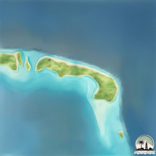
Geography and size of Horoatera
Size: 1.283 km²
Coastline: 7.5 km
Ocean: Pacific Ocean
Sea: South Pacific Ocean
Continent: Oceania
Horoatera is a Small Island spanning 1.3 km² with a coastline of 7.5 km.
Archipel: Society Islands – A group of islands in the South Pacific Ocean, part of French Polynesia, famous for their idyllic beauty, including Tahiti and Bora Bora.
Tectonic Plate: Pacific – The world’s largest tectonic plate, covering much of the Pacific Ocean, known for the Pacific Ring of Fire with extensive seismic and volcanic activity.
The geographic heart of the island is pinpointed at these coordinates:
Latitude: -16.99072423 / Longitude: -149.54622265
Climate and weather of Horoatera
Climate Zone: Tropical
Climate Details: Tropical Rainforest Climate
Temperature: Hot
Climate Characteristics: This climate is typified by heavy rainfall throughout the year, high humidity, and consistently high temperatures, leading to lush rainforests and rich biodiversity. Seasonal temperature variations are minimal.
Topography and nature of Horoatera
Timezone: UTC-10:00
Timezone places: Pacific/Honolulu
Max. Elevation: -27 m
Mean Elevation: -41 m
Vegetation: Shrubland
Tree Coverage: 55%
The mean elevation is -41 m. Remarkably, this unique island barely emerges above the sea level, showcasing nature’s fascinating interplay with the ocean. The island is characterized by Plains: Flat, low-lying lands characterized by a maximum elevation of up to 200 meters. On islands, plains are typically coastal lowlands or central flat areas.
Dominating Vegetation: Shrubland
Dominated by shrubs and small bushes, these areas are typical in dry, rocky, or sandy environments, as well as in regions with poor soil fertility. Horoatera has a tree cover of 55 %.
Vegetation: 3 vegetation zones – Moderately Diverse Island
These islands start to show a broader range of ecological niches. With three vegetation zones, they may offer a mix of ecosystems like coastal areas, inland woods, and perhaps a distinct wetland or dry area. This diversity supports a wider range of flora and fauna, making these islands more ecologically complex than those with minimal diversity.
Infrastructure and Travelling to Horoatera
Does the island have a public airport? no.
There is no public and scheduled airport on Horoatera. The nearest airport is Moorea Temae Airport, located 60 km away.
Does the island have a major port? no.
There are no major ports on Horoatera. The closest major port is PAPEETE, approximately 60 km away.
The mean population of Horoatera is 500 per km². Horoatera is Moderately Inhabited. The island belongs to France.
Continuing your journey, Moorea is the next notable island, situated merely km away.
HTP EP319 TETIAROA VESTIGES ARIOI HOROATERA FRA
France is classified as Developed region: G7: Group of Seven – Major advanced economies, including Canada, France, Germany, Italy, Japan, the United Kingdom, and the United States. The level of income is High income: OECD.
News – Latest Updates and Headlines from Horoatera
Stay informed with the most recent news and important headlines from Horoatera. Here’s a roundup of the latest developments.
Please note: The data used here has been primarily extracted from satellite readings. Deviations from exact values may occur, particularly regarding the height of elevations and population density. Land area and coastline measurements refer to average values at mean high tide.