Ikei Shima
Welcome to Ikei Shima, a Temperate island in the Philippine Sea, part of the majestic Pacific Ocean. This guide offers a comprehensive overview of what makes Ikei Shima unique – from its geography and climate to its population, infrastructure, and beyond. Dive into the details:
- Geography and Size: Explore the island’s size and location.
- Climate and Weather: Weather patterns and temperature.
- Topography and Nature: Uncover the natural wonders of the island.
- Infrastructure and Travelling: Insights on reaching, staying, and making the most of your visit.
- News and Headlines: Latest News.
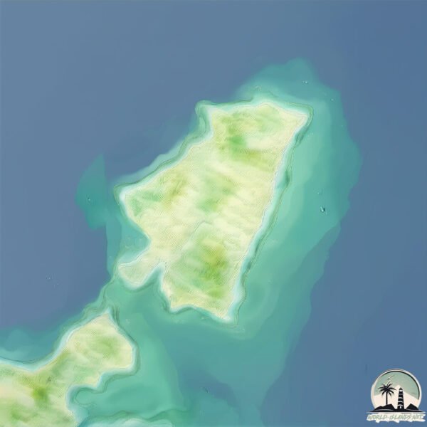
Geography and size of Ikei Shima
Size: 1.639 km²
Coastline: 6.8 km
Ocean: Pacific Ocean
Sea: Philippine Sea
Continent: Asia
Ikei Shima is a Small Island spanning 1.6 km² with a coastline of 6.8 km.
Archipel: Ryukyu Islands – A chain of Japanese islands stretching southwest from Kyushu to Taiwan, known for their unique Okinawan culture and subtropical climate.
Tectonic Plate: Yangtze – A minor tectonic plate in East Asia, often considered a part of the Eurasian Plate. It’s primarily continental and covers the Yangtze River area in China, playing a significant role in the region’s geological stability.
The geographic heart of the island is pinpointed at these coordinates:
Latitude: 26.39145807 / Longitude: 127.9966606
Climate and weather of Ikei Shima
Climate Zone: Temperate
Climate Details: Humid Subtropical Climate
Temperature: Hot Summer
Climate Characteristics: With continuous rainfall and hot summers, this climate is common in some coastal regions, supporting diverse vegetation.
Topography and nature of Ikei Shima
Timezone: UTC+09:00
Timezone places: Asia/Tokyo
Max. Elevation: 18 m
Mean Elevation: 16 m
Vegetation: Agricultural Mosaic
Tree Coverage: 35%
The mean elevation is 16 m. The highest elevation on the island reaches approximately 18 meters above sea level. The island is characterized by Plains: Flat, low-lying lands characterized by a maximum elevation of up to 200 meters. On islands, plains are typically coastal lowlands or central flat areas.
Dominating Vegetation: Agricultural Mosaic
A mix of cropland and natural vegetation, often seen in rural landscapes where agricultural fields are interspersed with patches of natural habitats. Ikei Shima has a tree cover of 35 %.
Vegetation: 5 vegetation zones – Highly Diverse Island
With five different vegetation zones, these islands offer a rich tapestry of ecosystems. The variety could include dense forests, open meadows, wetlands, coastal zones, and more. This level of diversity supports an intricate web of life, with each zone playing a vital role in the overall ecological health and balance of the island.
Infrastructure and Travelling to Ikei Shima
Does the island have a public airport? no.
There is no public and scheduled airport on Ikei Shima. The nearest airport is Naha Airport / JASDF Naha Air Base, located 44 km away.
Does the island have a major port? no.
There are no major ports on Ikei Shima. The closest major port is KIN WAN, approximately 10 km away.
The mean population of Ikei Shima is 1358 per km². Ikei Shima is Densely Populated. The island belongs to Japan.
Continuing your journey, Henza Jima is the next notable island, situated merely km away.
No. 224 Ikei Island in Okinawa Prefecture / Travels of Scenic Japan / Tabiator


Japan is classified as Developed region: G7: Group of Seven – Major advanced economies, including Canada, France, Germany, Italy, Japan, the United Kingdom, and the United States. The level of income is High income: OECD.
News – Latest Updates and Headlines from Ikei Shima
Stay informed with the most recent news and important headlines from Ikei Shima. Here’s a roundup of the latest developments.
Please note: The data used here has been primarily extracted from satellite readings. Deviations from exact values may occur, particularly regarding the height of elevations and population density. Land area and coastline measurements refer to average values at mean high tide.