Welcome to Île à la Pierre, a Continental island in the Gulf of St. Lawrence, part of the majestic Atlantic Ocean. This guide offers a comprehensive overview of what makes Île à la Pierre unique – from its geography and climate to its population, infrastructure, and beyond. Dive into the details:
Geography and size of Île à la Pierre
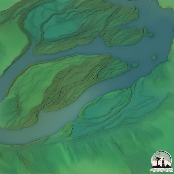
Size: 1.743 km²
Coastline: 15.3 km
Ocean: Atlantic Ocean
Sea: Gulf of St. Lawrence
Continent: North America
Île à la Pierre is a Small Island spanning 1.7 km² with a coastline of 15.3 km.
Archipel: –
Tectonic Plate: North America – Covers North America and parts of the Atlantic and Arctic Oceans, characterized by diverse geological features and varying levels of seismic activity.
The geographic heart of the island is pinpointed at these coordinates:
Latitude: 46.09298819 / Longitude: -73.00845153
Climate and weather of Île à la Pierre
Climate Zone: Continental
Climate Details: Warm-Summer Humid Continental Climate
Temperature: Warm Summer
Climate Characteristics: Features warm summers and cold winters with consistent precipitation, common in higher latitudes.
Topography and nature of Île à la Pierre
Timezone: UTC-05:00
Timezone places: America/New_York
Max. Elevation: 7 m
Mean Elevation: 4 m
Vegetation: Mixed Forest
Tree Coverage: 85%
The mean elevation is 4 m. The highest elevation on the island reaches approximately 7 meters above sea level. The island is characterized by Plains: Flat, low-lying lands characterized by a maximum elevation of up to 200 meters. On islands, plains are typically coastal lowlands or central flat areas.
Dominating Vegetation: Mixed Forest
A combination of both deciduous and evergreen trees, often found in transitional zones between forest types. These forests offer a diverse habitat for various wildlife species. Île à la Pierre has a tree cover of 85 %.
Vegetation: 5 vegetation zones – Highly Diverse Island
With five different vegetation zones, these islands offer a rich tapestry of ecosystems. The variety could include dense forests, open meadows, wetlands, coastal zones, and more. This level of diversity supports an intricate web of life, with each zone playing a vital role in the overall ecological health and balance of the island.
Infrastructure and Travelling to Île à la Pierre
Does the island have a public airport? no.
There is no public and scheduled airport on Île à la Pierre. The nearest airport is Montréal / Saint-Hubert Airport, located 75 km away.
Does the island have a major port? no.
There are no major ports on Île à la Pierre. The closest major port is SOREL, approximately 10 km away.
The mean population of Île à la Pierre is 0 per km². Île à la Pierre is Uninhabited. The island belongs to Canada.
Continuing your journey, Île de Grâce is the next notable island, situated merely km away.
Seychelles 2008 - Saint Pierre Island
In 2008 we had an opportunity to experience the breathtaking beauty of Praslin Island in Seychelles. The footage is quite old now, ...Seychelles 2008 - Saint Pierre Island
In 2008 we had an opportunity to experience the breathtaking beauty of ...
In 2008 we had an opportunity to experience the breathtaking beauty of Praslin Island in Seychelles. The footage is quite old now, ...
Newfoundland Travel Guide: Saint Pierre and Miquelon Vacation - North America's France
Welcome to St. Pierre et Miquelon, a slice of France in North America! ...
Welcome to St. Pierre et Miquelon, a slice of France in North America! Saint Pierre and Miquelon to Canada is only 25 kilometres!
Exploring Historic St. Pierre! France’s Hidden Island! 🇵🇲
In this episode, I explore the quiet, colorful streets of St. Pierre, ...
In this episode, I explore the quiet, colorful streets of St. Pierre, uncover historic sites, and watch the sunrise over L'Île-aux-Marins.
St. Pierre & Miquelon- France’s most awkward island
🔥【4K超清】EP180-190 FULL!萧炎获净莲妖圣传承争夺异火!魂殿千年阴谋千年谋划即将曝光,危机接近!
Drama Name:《斗破苍穹 Battle Through the Heavens》 #fightsbreaksphere #萧炎 ...
Drama Name:《斗破苍穹 Battle Through the Heavens》 #fightsbreaksphere #萧炎 #chineseanime#btth #热血动漫社#中国动漫#薰 ...
KİMSESİZ TROPİK ADADA 72 SAAT KAMP - Tayland lanetli olduğuna inanıyor!!
Yolcuların Dikkatine kanalının yeni videosuna hoş geldiniz. Bu videoda ...
Yolcuların Dikkatine kanalının yeni videosuna hoş geldiniz. Bu videoda iki zıt dünyayı bir arada gördük. Bir yanda turkuaz denizi, ...
Ile aux Marins - The ghost island of St Pierre & Miquelon
St Pierre has its own secret ghost island abandoned in 1965 ...
St Pierre has its own secret ghost island abandoned in 1965 *Subscribe* for more adventures Ile aux Marins - The ghost island of ...
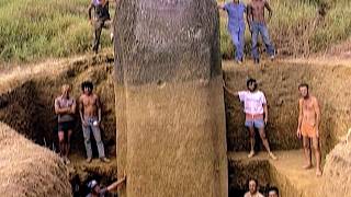
Île de Pâques : le mystère qui déchire les scientifiques
Depuis des siècles, les statues de l'île de Pâques intriguent les ...
Depuis des siècles, les statues de l'île de Pâques intriguent les archéologues. Comment un peuple isolé, sans roue ni machine, ...
Un archipel dans leur cœur : découvrez la vie à Saint-Pierre-et-Miquelon 🇵🇲✨ #voyage #outremer
Island-Hopping: A bit of France closer to home
They may appear on the map to be a part of Canada. But for more than a ...
They may appear on the map to be a part of Canada. But for more than a century, the tiny islands of Saint Pierre and Miquelon, ...
Île de Pâques : le mystère des statues géantes enfin résolu ?
Comment sont-elles arrivées là ? Qui les a taillées ? Comment ...
Comment sont-elles arrivées là ? Qui les a taillées ? Comment ont-elles été transportées ? Aujourd'hui Jamy perce le mystère !
2017 07 06 Praslin, St Pierre island
short video of St Pierre island used for snorkeling at Praslin, Seychelles.
short video of St Pierre island used for snorkeling at Praslin, Seychelles.
Tempête de neige à Saint-Pierre et Miquelon, fermeture historique de l'aéroport. #tempête
saintpierreetmiquelon #tempete #meteo.
saintpierreetmiquelon #tempete #meteo.
La face cachée de Socotra… 🏝️ #actu #info #géographie #histoire #culture #travel #Backpack
Western Atlantic Belle Isle Island St Pierre Island Group Labrador Sea In Google Earth and GoogleMap
Western Atlantic Belle Isle Island St Pierre Island Group Labrador Sea ...
Western Atlantic Belle Isle Island St Pierre Island Group Labrador Sea Canada In Google Earth and Google Maps.
Curieuse + St.Pierre Island Excursion Seychelles
Is the trip to Curieuse und St.Pierre worth it from Praslin in the ...
Is the trip to Curieuse und St.Pierre worth it from Praslin in the Seychelles? We tried it out for snorkeling, BBQ, beaches and ...
France just 45 mins from Canada... Have you heard of Saint Pierre & Miquelon? 🇫🇷🤯 #france #canada
France 20km from Canada Did you know you can visit France in just 45 ...
France 20km from Canada Did you know you can visit France in just 45 minutes from Canada?! Saint-Pierre & Miquelon is ...
Géographie de l'île d'Oléron
Que faire à l’Île Maurice ? Voici 5 spots incontournables 🌴
4K UHD St. Pierre Island | Beautiful Island | Relaxing Island Video #short
Welcome to my channel, St. Pierre Island - Beautiful Island If you ...
Welcome to my channel, St. Pierre Island - Beautiful Island If you like it, please subscribe to my channel to receive new video ...
Les plus belles plages de l’île Maurice 👇🏽
Cette sélection des plus belles plages est évidemment personnelle et ...
Cette sélection des plus belles plages est évidemment personnelle et est faite en fonction de critères qui nous est propre.
The Lost World - Easter Island
Discovered in the 18th century 3700 km from the Chilean coast by Jacob ...
Discovered in the 18th century 3700 km from the Chilean coast by Jacob Roggeveen, Easter Island has always fascinated with its ...
7 Reasons to Visit St. Pierre et Miquelon this Summer! #stpierre #stpierreetmiquelon #travel #france
Did you know that France is only a 1hr and 15 minute flight from ...
Did you know that France is only a 1hr and 15 minute flight from Halifax, Nova Scotia? Here are 7 great reasons to visit the French ...
Saint Pierre and Miquelon (Like vs Dislike)
The Ruins of Saint Pierre
This is the City of Saint Pierre on the Island of Martinique which was ...
This is the City of Saint Pierre on the Island of Martinique which was destroyed by a vulkano in 1902 - just like Pompeji.
Canada is classified as Developed region: G7: Group of Seven – Major advanced economies, including Canada, France, Germany, Italy, Japan, the United Kingdom, and the United States. The level of income is High income: OECD.
News – Latest Updates and Headlines from Île à la Pierre
Stay informed with the most recent news and important headlines from Île à la Pierre. Here’s a roundup of the latest developments.
Loading...
Please note: The data used here has been primarily extracted from satellite readings. Deviations from exact values may occur, particularly regarding the height of elevations and population density. Land area and coastline measurements refer to average values at mean high tide.