Welcome to Île au Sable, a Continental island in the Gulf of St. Lawrence, part of the majestic Atlantic Ocean. This guide offers a comprehensive overview of what makes Île au Sable unique – from its geography and climate to its population, infrastructure, and beyond. Dive into the details:
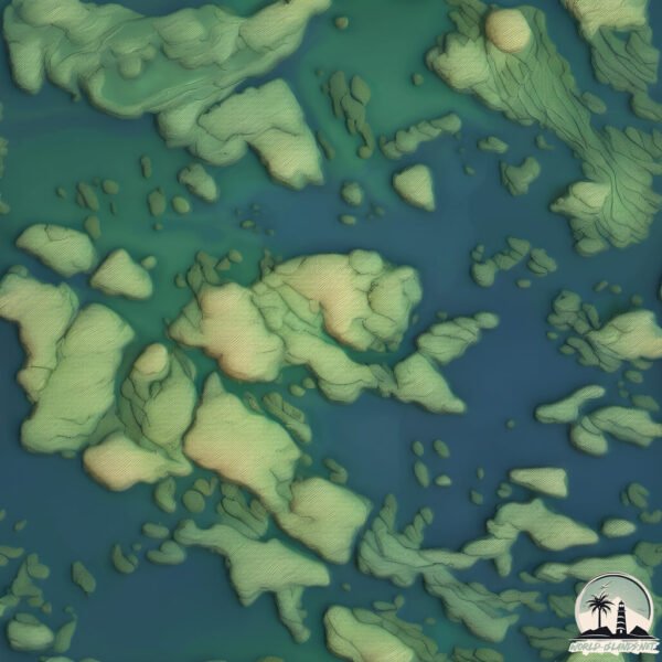
Geography and size of Île au Sable
Size: 2.938 km²
Coastline: 13.6 km
Ocean: Atlantic Ocean
Sea: Gulf of St. Lawrence
Continent: North America
Île au Sable is a Small Island spanning 2.9 km² with a coastline of 13.6 km.
Archipel: –
Tectonic Plate: North America – Covers North America and parts of the Atlantic and Arctic Oceans, characterized by diverse geological features and varying levels of seismic activity.
The geographic heart of the island is pinpointed at these coordinates:
Latitude: 50.6693784 / Longitude: -59.27609399
Climate and weather of Île au Sable
Climate Zone: Continental
Climate Details: Subarctic Climate
Temperature: Cold Summer
Climate Characteristics: Characterized by long, extremely cold winters and short, cool summers, often found in northern latitudes of North America and Eurasia.
Topography and nature of Île au Sable
Timezone: UTC-04:00
Timezone places: America/La_Paz
Max. Elevation: 12 m
Mean Elevation: 7 m
Vegetation: Open Woodland
Tree Coverage: 97%
The mean elevation is 7 m. The highest elevation on the island reaches approximately 12 meters above sea level. The island is characterized by Plains: Flat, low-lying lands characterized by a maximum elevation of up to 200 meters. On islands, plains are typically coastal lowlands or central flat areas.
Dominating Vegetation: Open Woodland
Characterized by sparsely distributed trees with open canopy allowing sunlight to penetrate, supporting grasses and shrubs underneath. Often found in drier or transitional environments. Île au Sable has a tree cover of 97 %.
Vegetation: 7 vegetation zones – Very Highly Diverse Island
Islands in this range are ecological powerhouses, showcasing a wide array of vegetation zones. Each zone, from lush rainforests to arid scrublands, coastal mangroves to mountainous regions, contributes to a complex and interdependent ecosystem. These islands are often hotspots of biodiversity, supporting numerous species and intricate ecological processes.
Infrastructure and Travelling to Île au Sable
Does the island have a public airport? no.
There is no public and scheduled airport on Île au Sable. The nearest airport is Tête-à-la-Baleine Airport, located 10 km away.
Does the island have a major port? no.
There are no major ports on Île au Sable. The closest major port is CORNER BROOK, approximately 239 km away.
The mean population of Île au Sable is 0 per km². Île au Sable is Uninhabited. The island belongs to Canada.
Continuing your journey, Île du Petit Mécatina is the next notable island, situated merely km away.
Land & Sea: Sable Island
Sable Island is soon to be one of Canada's newest national parks. But what is the balance between giving more people access to ...Land & Sea: Sable Island
Sable Island is soon to be one of Canada's newest national parks. But ...
Sable Island is soon to be one of Canada's newest national parks. But what is the balance between giving more people access to ...
Sable Island As you've never seen before
Last Summer I was given the opportunity of a lifetime to travel to one ...
Last Summer I was given the opportunity of a lifetime to travel to one of the most remote wonders of the world. Sable Island, now a ...
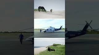
Take a Trip With us to the Famous Sable Island, Where Wild Horses Roam
Wild horses and gray seals mingle on the snow-covered sand dunes of ...
Wild horses and gray seals mingle on the snow-covered sand dunes of this famous National Park Reserve. The Weather ...
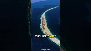
Discover Sable Island National Park Reserve
Far out in the North Atlantic sits Sable Island National Park Reserve, ...
Far out in the North Atlantic sits Sable Island National Park Reserve, a wild and windswept island of sand. This crescent shaped ...
150 Sable Island wild horses died last winter, Parks Canada reports
Sable Island ecologist Dan Kehler says the horses are most vulnerable ...
Sable Island ecologist Dan Kehler says the horses are most vulnerable in late winter when their energy reserves are low and ...
Shipwrecks and Graves: The Ruins of Cape Sable Island
If you enjoyed this video, please consider joining my Patreon to help ...
If you enjoyed this video, please consider joining my Patreon to help create more videos like this!
WORLD'S Secret Island? The Sable Island
Join us as we uncover the secrets of Sable Island, a mysterious ...
Join us as we uncover the secrets of Sable Island, a mysterious Atlantic gem known for its wild horses and unique ecosystem.
Canada's Island of Horses? | Canada's Strangest Islands Part 3. | Sable Island
In this video we talk about Sable Island, including its unique ...
In this video we talk about Sable Island, including its unique geography and wildlife on this edition of Canada's Strangest Islands.
The Curious Case of the Sable Island Seal Killer
Do you want to hear Simon talk about insane criminal stuff? OF COURSE ...
Do you want to hear Simon talk about insane criminal stuff? OF COURSE YOU DO. So subscribe to the Casual Criminalist on ...
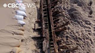
Découvrir une épave sur l'île de Sable | Parcs Canada
Joignez-vous aux archéologues de Parcs Canada alors qu'ils font une ...
Joignez-vous aux archéologues de Parcs Canada alors qu'ils font une découverte passionnante : les vestiges d'un groupe de ...
Sable Island Horses: Wild Beauties of the Maritime Province
Sable Island Horses: Wild Beauties of the Maritime Province Experience ...
Sable Island Horses: Wild Beauties of the Maritime Province Experience the untamed beauty of Sable Island as you gallop along ...
The Secret of Sable Island
RMR: Rick Visits Sable Island
Rick visits one of Canada's newest national parks off the coast of ...
Rick visits one of Canada's newest national parks off the coast of Nova Scotia.
Sable Island: The Graveyard of the Atlantic
Discover the haunting beauty of **Sable Island**, often dubbed the ...
Discover the haunting beauty of **Sable Island**, often dubbed the "Graveyard of the Atlantic." Located 300 kilometers southeast ...
Fly over Sable Island in 360 | Parks Canada
Please select 2160s/4K quality for a better viewing experience ...
Please select 2160s/4K quality for a better viewing experience (Settings, Quality). Soar over Sable Island National Park Reserve, ...
Explore TV - Sable Island, National Park Reserve, Nova Scotia
On the edge of the Continental Shelf in the North Atlantic, sits ...
On the edge of the Continental Shelf in the North Atlantic, sits beautiful and tranquil Sable Island; a vegetated sand bar ...
Uncovering shipwrecks on Sable Island | Parks Canada
Join Parks Canada archaeologists as they make an exciting discovery – ...
Join Parks Canada archaeologists as they make an exciting discovery – the remains of a group of 19th century vessels, buried in ...
The Graveyard of the Atlantic; Canada's Isolated Island
The graveyard of the Atlantic Ocean where more than 200 shipwrecks ...
The graveyard of the Atlantic Ocean where more than 200 shipwrecks have occurred is a highly remote island named Sable ...
The Island Ruled by Wild Horses 🐎
Sable Island is one of the most mysterious places in Canada. Home to ...
Sable Island is one of the most mysterious places in Canada. Home to over 400 wild horses, this remote island has no permanent ...
Sable Island Photography #sableisland #helicopter #novascotia #wildhorses
flying over Sable Island NPR
Walkabout S3E12 Sable Island Part 1
S3E12: In the first of a two part episode we find ourselves 300km ...
S3E12: In the first of a two part episode we find ourselves 300km southeast of Halifax on a sand dune rising above the Atlantic ...
Why Sable Island archeologists are celebrating a rare discovery
Archaeologists working on Sable Island are celebrating a rare ...
Archaeologists working on Sable Island are celebrating a rare discovery. During an excavation last May, they found surprisingly ...
Canada’s Wild Horse Island
Sable Island in Canada is home to a unique population of wild horses ...
Sable Island in Canada is home to a unique population of wild horses that roam free across its remote landscape.
WHY IS THIS DESERT ISLAND INFESTED WITH HORSES? Sable Island: The Wild Horse Paradise You Must See!
Sable Island: The Enigmatic Home of Wild Horses Nestled in the ...
Sable Island: The Enigmatic Home of Wild Horses Nestled in the Atlantic Ocean, approximately 300 kilometers southeast of ...
Canada is classified as Developed region: G7: Group of Seven – Major advanced economies, including Canada, France, Germany, Italy, Japan, the United Kingdom, and the United States. The level of income is High income: OECD.
News – Latest Updates and Headlines from Île au Sable
Stay informed with the most recent news and important headlines from Île au Sable. Here’s a roundup of the latest developments.
Loading...
Please note: The data used here has been primarily extracted from satellite readings. Deviations from exact values may occur, particularly regarding the height of elevations and population density. Land area and coastline measurements refer to average values at mean high tide.