Welcome to Île aux Moines, a Temperate island in the Bay of Biscay, part of the majestic Atlantic Ocean. This guide offers a comprehensive overview of what makes Île aux Moines unique – from its geography and climate to its population, infrastructure, and beyond. Dive into the details:
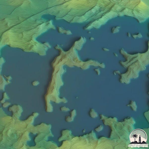
Geography and size of Île aux Moines
Size: 3.838 km²
Coastline: 18.3 km
Ocean: Atlantic Ocean
Sea: Bay of Biscay
Continent: Europe
Île aux Moines is a Small Island spanning 3.8 km² with a coastline of 18.3 km.
Archipel: –
Tectonic Plate: Eurasia – One of the world’s largest tectonic plates, the Eurasian Plate covers a significant portion of Europe and Asia. It’s characterized by diverse geological features, including the Ural Mountains, the European Plain, and the Himalayas formed from its collision with the Indian Plate.
The geographic heart of the island is pinpointed at these coordinates:
Latitude: 47.5861838 / Longitude: -2.84820779
Climate and weather of Île aux Moines
Climate Zone: Temperate
Climate Details: Temperate Oceanic Climate
Temperature: Warm Summer
Climate Characteristics: Known for its moderate year-round temperatures with ample rainfall and no dry season. Warm summers are characteristic.
Topography and nature of Île aux Moines
Timezone: UTC+01:00
Timezone places: Europe/Paris
Max. Elevation: 13 m
Mean Elevation: 8 m
Vegetation: Evergreen Needleleaf Forest
Tree Coverage: 80%
The mean elevation is 8 m. The highest elevation on the island reaches approximately 13 meters above sea level. The island is characterized by Plains: Flat, low-lying lands characterized by a maximum elevation of up to 200 meters. On islands, plains are typically coastal lowlands or central flat areas.
Dominating Vegetation: Evergreen Needleleaf Forest
Dominated by evergreen coniferous trees such as pines and firs, which retain their needle-like leaves throughout the year. These forests are often found in cooler climates. Île aux Moines has a tree cover of 80 %.
Vegetation: 5 vegetation zones – Highly Diverse Island
With five different vegetation zones, these islands offer a rich tapestry of ecosystems. The variety could include dense forests, open meadows, wetlands, coastal zones, and more. This level of diversity supports an intricate web of life, with each zone playing a vital role in the overall ecological health and balance of the island.
Infrastructure and Travelling to Île aux Moines
Does the island have a public airport? no.
There is no public and scheduled airport on Île aux Moines. The nearest airport is Lorient South Brittany (Bretagne Sud) Airport, located 67 km away.
Does the island have a major port? no.
There are no major ports on Île aux Moines. The closest major port is LORIENT, approximately 57 km away.
The mean population of Île aux Moines is 159 per km². Île aux Moines is Moderately Inhabited. The island belongs to France.
Continuing your journey, Belle-Île-en-Mer is the next notable island, situated merely km away.
🧭 L'ÎLE AUX MOINES (56) : LA PERLE DU GOLFE DU MORBIHAN (BRETAGNE) - VLOG#15
Au cœur du golfe du Morbihan, l'Île aux Moines n'est qu'à quelques minutes en bateau du continent. Au gré des sentiers, ...🧭 L'ÎLE AUX MOINES (56) : LA PERLE DU GOLFE DU MORBIHAN (BRETAGNE) - VLOG#15
Au cœur du golfe du Morbihan, l'Île aux Moines n'est qu'à quelques ...
Au cœur du golfe du Morbihan, l'Île aux Moines n'est qu'à quelques minutes en bateau du continent. Au gré des sentiers, ...
Beautiful island Île-aux-Moines France
Île-aux-Moines is a commune in the Morbihan department in the region ...
Île-aux-Moines is a commune in the Morbihan department in the region of Brittany in northwestern France. It is the largest island in ...
Pierre & Vacances - Notre résidence La Voile D'or*** sur l'Île aux Moines
À seulement 5 min en bateau du continent, découvrez un petit paradis ...
À seulement 5 min en bateau du continent, découvrez un petit paradis insulaire surnommé "La perle du Golf". A vélo ou à pied, ...
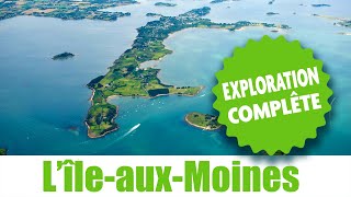
ILE-AUX-MOINES - Exploration complète de l'île - 1080p - HD - Vous allez tout découvrir !!
Avant toute chose sélectionnez 1080p dans la qualité vidéo de votre ...
Avant toute chose sélectionnez 1080p dans la qualité vidéo de votre lecteur youtube. L'ile-aux-Moines est située dans le Golfe du ...
ÎLE-AUX-MOINES | ⛴️ Destination Île-aux-Moines | Izenah Télé
L'Île-aux-Moines et ses bateaux. L'Île-aux-Moines est sublime. Les ...
L'Île-aux-Moines et ses bateaux. L'Île-aux-Moines est sublime. Les portes de l'Île-aux-Moines dans le Golfe du #Morbihan près de ...
BRETAGNE 🇲🇫 | Île-aux-Moines Golf van Morbihan | Nederland Bretagne TV 🇳🇱
Île-aux-Moines / Bretagne. Dit charmante eiland, vaak beschreven als ...
Île-aux-Moines / Bretagne. Dit charmante eiland, vaak beschreven als de “parel van de Golf”, biedt een unieke combinatie van ...
Île-aux-Moines beautiful France island
Île-aux-Moines is a commune in the Morbihan department in the region ...
Île-aux-Moines is a commune in the Morbihan department in the region of Brittany in northwestern France. It is the largest island in ...
066 TOUR DE L'ÎLE AUX MOINES
Relive de la randonnée "Le tour de l'île aux Moines" Compte rendu : ...
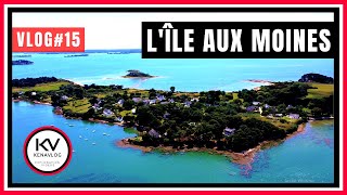
L'Île aux Moines vue du ciel
l'Île aux moines vue du ciel. Vidéo tournée le 08/05/2018.
l'Île aux moines vue du ciel. Vidéo tournée le 08/05/2018.
ÎLE-AUX-MOINES 🇲🇫 | Juillet au Port | Izenah Télé
Dans le Golfe du Morbihan, l'Île-aux-Moines est sublime. Les ...
Dans le Golfe du Morbihan, l'Île-aux-Moines est sublime. Les Juilletistes viennent visiter l'Île-aux -Moines en embarquant sur le ...
Île aux moines 4k
Balade sur l'île aux moines au levé du soleil. Boîte de prod : Mavic ...
Balade sur l'île aux moines au levé du soleil. Boîte de prod : Mavic Armor N'hésitez pas à nous contacter pour tout type de ...
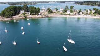
l'île aux Moines - Golfe du Morbihan
Vue aériennes d'une des plages de l'île aux Moines. #dji #drone ...
Vue aériennes d'une des plages de l'île aux Moines. #dji #drone #bretagne #fromthesky #golfedumorbihan #arzon #sarzeau.
L'île aux Moines, Morbihan [FR] 1080p
Toutes les séquences vidéo appartiennent à l'Odyssée de Curtix.
Toutes les séquences vidéo appartiennent à l'Odyssée de Curtix.
GOLFE du MORBIHAN | Baden espionne l'Île-aux-Moines | TV Golfe
Golfe du Morbihan / Bretagne. Dans le Golfe du Morbihan, Port Blanc à ...
Golfe du Morbihan / Bretagne. Dans le Golfe du Morbihan, Port Blanc à Baden est juste en face de l'Île-aux-Moines. Le ballet des ...
Patrimoine : Île-aux-Moines et vieux gréements
Cap sur le golfe du Morbihan, pour découvrir l'île-aux-moines. Outre ...
Cap sur le golfe du Morbihan, pour découvrir l'île-aux-moines. Outre son climat doux et ses sublimes paysages, l'île possède une ...
LINE L'ÎLE AUX MOINES 1
BALADES OCEANES Une balade, un bol d'air, un peu d'histoire, un site à ...
BALADES OCEANES Une balade, un bol d'air, un peu d'histoire, un site à découvrir?... Retrouvez, chaque semaine Line dans ...
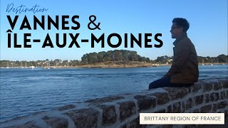
Filipino Tourist in France: Visiting Vannes and Île-aux-Moines!
Sometimes, it's good to explore the little towns and islands of a ...
Sometimes, it's good to explore the little towns and islands of a country rather than just visiting its big cities. You get to discover ...
ÎLE-AUX-MOINES | Génial l'Hiver sur l'Île-aux-Moines | Izenah Télé
L'Île-aux-Moines est sublime. L'Île-aux-Moines se repose mais ne dort ...
L'Île-aux-Moines est sublime. L'Île-aux-Moines se repose mais ne dort pas l'hiver. L'IÎe-aux-Moines est située à quelques ...
L’Île aux moines, la belle île bretonne 🤩👀 Qui est déjà allé? #ileauxmoines #ile #bretagne #mer
L'Ile aux moines est une île Bretonne extrêmement bien cotée. Elle se ...
L'Ile aux moines est une île Bretonne extrêmement bien cotée. Elle se situe dans le Golf du Morbihan et est accessible ...
L'Ile aux Moines (France) (Bretagne)
L'Île-aux-Moines est une commune française, située dans le département ...
L'Île-aux-Moines est une commune française, située dans le département du Morbihan en région Bretagne. Elle est constituée de ...
ILE AUX MOINES -- GOLFE DU MORBIHAN -- Visite en Famille Eté 2016
Cette île du golfe du Morbihan est un véritable joyau qui mérite ...
Cette île du golfe du Morbihan est un véritable joyau qui mérite d'être visitée... Musique : Iced Coffees /Ben Benjamin.
Ile aux moines Golfe du Morbihan
Prenez les commandes du bateau de Port Blanc à l'île aux Moines....Une ...
Prenez les commandes du bateau de Port Blanc à l'île aux Moines....Une petite promenade sur l'Île et découvrez le golf du ...
ÎLE AUX MOINES | Le bon Ferry | Îles du Ponant TV
Dans le Golfe du Morbihan, l'Ile aux Moines est l'une des iles du ...
Dans le Golfe du Morbihan, l'Ile aux Moines est l'une des iles du Ponant. Les vacanciers viennent visiter l'Ile aux Moines en ...
Île-aux-Moines
Video Software we use:
https://amzn.to/2KpdCQF Ad-free videos. You can support us by purchasing something through our ...
ÎLE-AUX-MOINES 🇲🇫 | Un si bon Bateau | Izenah Télé
Île-aux-Moines / Bretagne. C'est une petite Croisière qui s'amuse, ...
Île-aux-Moines / Bretagne. C'est une petite Croisière qui s'amuse, pour se rendre à l'Île-aux-Moines, non loin de Vannes, il faut ...
France is classified as Developed region: G7: Group of Seven – Major advanced economies, including Canada, France, Germany, Italy, Japan, the United Kingdom, and the United States. The level of income is High income: OECD.
News – Latest Updates and Headlines from Île aux Moines
Stay informed with the most recent news and important headlines from Île aux Moines. Here’s a roundup of the latest developments.
Loading...
Please note: The data used here has been primarily extracted from satellite readings. Deviations from exact values may occur, particularly regarding the height of elevations and population density. Land area and coastline measurements refer to average values at mean high tide.


![L'île aux Moines, Morbihan [FR] 1080p](https://i.ytimg.com/vi/-_qN2VZeja8/mqdefault.jpg)