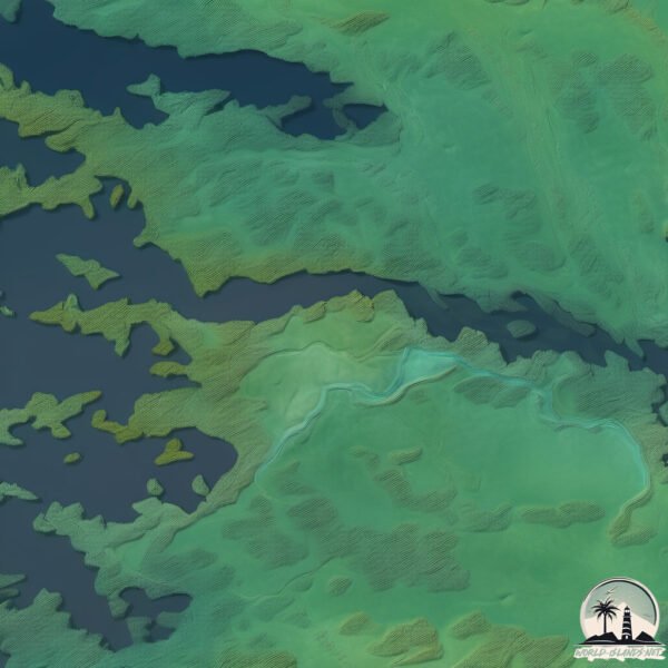
Welcome to Île de Fort George, a Continental island in the Hudson Bay, part of the majestic Arctic Ocean. This guide offers a comprehensive overview of what makes Île de Fort George unique – from its geography and climate to its population, infrastructure, and beyond. Dive into the details:
Geography and size of Île de Fort George
Size: 9.278 km²
Coastline: 21.8 km
Ocean: Arctic Ocean
Sea: Hudson Bay
Continent: North America
Île de Fort George is a Small Island spanning 9.3 km² with a coastline of 21.8 km.
Archipel: –
Tectonic Plate: North America – Covers North America and parts of the Atlantic and Arctic Oceans, characterized by diverse geological features and varying levels of seismic activity.
The geographic heart of the island is pinpointed at these coordinates:
Latitude: 53.82355175 / Longitude: -79.01653511
Climate and weather of Île de Fort George
Climate Zone: Continental
Climate Details: Dry-Summer Subarctic Climate
Temperature: Cold Summer
Climate Characteristics: Short, mild summers with significantly less moisture, and prolonged cold periods. Found in northern, inland regions.
Topography and nature of Île de Fort George
Timezone: UTC-05:00
Timezone places: America/New_York
Max. Elevation: 5 m
Mean Elevation: -1 m
Vegetation: Herbaceous Cover
Tree Coverage: 37%
The mean elevation is -1 m. The highest elevation on the island reaches approximately 5 meters above sea level. The island is characterized by Plains: Flat, low-lying lands characterized by a maximum elevation of up to 200 meters. On islands, plains are typically coastal lowlands or central flat areas.
Dominating Vegetation: Herbaceous Cover
Comprising mainly of grasses, herbs, and ferns, these areas are common in prairies, meadows, and savannas, and can vary widely in species composition. Île de Fort George has a tree cover of 37 %.
Vegetation: 7 vegetation zones – Very Highly Diverse Island
Islands in this range are ecological powerhouses, showcasing a wide array of vegetation zones. Each zone, from lush rainforests to arid scrublands, coastal mangroves to mountainous regions, contributes to a complex and interdependent ecosystem. These islands are often hotspots of biodiversity, supporting numerous species and intricate ecological processes.
Infrastructure and Travelling to Île de Fort George
Does the island have a public airport? no.
There is no public and scheduled airport on Île de Fort George. The nearest airport is Chisasibi Airport, located 4 km away.
Does the island have a major port? no.
There are no major ports on Île de Fort George. The closest major port is KEY HARBOUR, approximately 901 km away.
The mean population of Île de Fort George is 3 per km². Île de Fort George is Gently Populated. The island belongs to Canada.
Continuing your journey, South Twin Island is the next notable island, situated merely km away.
Fort George Island
Fort George Island is located at the mouth of the La Grande River on the James Bay coast of Quebec. This is Cree territory, and it ...Fort George Island
Fort George Island is located at the mouth of the La Grande River on ...
Fort George Island is located at the mouth of the La Grande River on the James Bay coast of Quebec. This is Cree territory, and it ...
Firsthand Florida Fun: Fort George Island State Park
Built to defend the southern flank of Georgia when it was a colony, ...
Built to defend the southern flank of Georgia when it was a colony, Fort George Island Cultural State Park and it's key attraction, ...
Fort-George island
Mamooweedow 2013 sunset- weird funny cool silly moments.
Mamooweedow 2013 sunset- weird funny cool silly moments.
Fort George
Every summer we go back to our beloved island of Fort George. Its a ...
Every summer we go back to our beloved island of Fort George. Its a special time as we celebrate our past. It s been many years ...
Fort George Island Coastal Taiga
Coastal boreal forest/taiga at Fort George Island on the James Bay ...
Coastal boreal forest/taiga at Fort George Island on the James Bay coast of Quebec, 24 Aug 2015.
Ft. George Island, Florida, where the History Lives On
Embark on a journey to Ft. George Island, Florida, where the whispers ...
Embark on a journey to Ft. George Island, Florida, where the whispers of the past meet the tranquility of nature. This picturesque ...
The Kingsley Plantation - Cotton, Slavery, & Survival on Fort George Island
Show # 62 of the "History Jacksonville!" series Film Date Saturday, ...
Show # 62 of the "History Jacksonville!" series Film Date Saturday, November 25, 2017 & Broadcast Date Sunday, November 26, ...
Kingsley Plantation - Fort George Island - Jacksonville, FL
We took a trip across the St. Johns River aboard the Mayport Ferry to ...
We took a trip across the St. Johns River aboard the Mayport Ferry to Fort George Island to visit the historic Kingsley Plantation.
Fort George Island Biking | Heritage River Road Wetlands
Every morning I ride 20+ miles in the Arlington area, but on this ride ...
Every morning I ride 20+ miles in the Arlington area, but on this ride I headed down to Mayport to catch the ferry across the St.
Biking & Birding in Fort George Island. 30 miles Fort George Island to Spoonbill Pond at Big Talbot.
Biking and birding. On and off-road biking adventure from Fort George ...
Biking and birding. On and off-road biking adventure from Fort George Island trails to Spoonbill Pond at Big Talbot Island.
Little Talbot Island Camping and Night Hike | Fort George Island
Little Talbot Island Camping and Hiking with my sons Tenver and ...
Little Talbot Island Camping and Hiking with my sons Tenver and Teimar. We did some night hiking under the bright stars.
The Story of Kingsley Plantation | Florida’s Hidden History
Step back in time with a visit to Kingsley Plantation, located on Fort ...
Step back in time with a visit to Kingsley Plantation, located on Fort George Island in Florida. This historic site offers a powerful ...
Birding & Biking at Big Talbot Island | Gray Kingbird | Painted Bunting at Fort George Island
I spent the morning birding and biking from Big Talbot Island to Fort ...
I spent the morning birding and biking from Big Talbot Island to Fort George Island. I found the Gray Kingbird at Little Talbot and ...
St George Island at Kingsley Plantation historical island with natural beauty!
Historical Kingsley Plantation at Ft George Island in Florida! 🏘️ ...
Historical Kingsley Plantation at Ft George Island in Florida! 🏘️ #historicalplace #natureshortsvideo #kingsley #florida ...
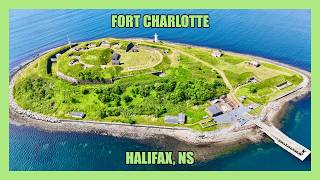
Exploring ABANDONED Fort Charlotte on Georges Island (Halifax, NS, Canada)
J-MASS INSTAGRAM: @jmassofficial The official theme song for my ...
J-MASS INSTAGRAM: @jmassofficial The official theme song for my channel, “City of Steam”, was originally composed by my ...
St George Island FL. 🌊🐚🌴
Beautiful day on St George Island in Florida.
Beautiful day on St George Island in Florida.
This Island Was Off Limits For Generations | Georges Island | Halifax Nova Scotia【4K】
Georges Island, named after King George II is a glacial drumlin within ...
Georges Island, named after King George II is a glacial drumlin within Halifax harbour Nova Scotia, Canada. The Island was first ...
Georges Island: A Hidden Gem in the Boston Harbor
Join us on a journey to one of the most beautiful and historic islands ...
Join us on a journey to one of the most beautiful and historic islands in the Boston area - George's Island. Located in the Boston ...
Catching Red Drum Near Ft. George Island, Florida
Catching Red Drum.
Catching Red Drum.
Trinidad and Tobago!!| The View From Fort George Tobago| Caribbean Tourist Attraction 2017
Omg this view is soooo beautiful. Trinidad and Tobago is beautiful!
Omg this view is soooo beautiful. Trinidad and Tobago is beautiful!
St George Island SHELL HAUL 👀
sanddollar #shellinginflorida #beachcombing Subscribe @BeachBumminDad ...
sanddollar #shellinginflorida #beachcombing Subscribe @BeachBumminDad Everyday is different. One day there will be shells ...
Saint George Island!!! #1 Beach in the United States!!!!
4⭐ Fort George Hotel & Spa Hotel Review - Belize City | Belize City's 1st UPSCALE hotel (Dec 2025).
Fort George Hotel & Spa 2 Marine Parade Blvd BELIZE CITY Belize Tel ...
Fort George Hotel & Spa 2 Marine Parade Blvd BELIZE CITY Belize Tel No. 1-800-503-2330 Website: Fort George Hotel & Spa ...
St. George Island State Park
St. George Island🐚🌴
shellinginflorida #sanddollar #beachcombing Subscribe @BeachBumminDad
shellinginflorida #sanddollar #beachcombing Subscribe @BeachBumminDad
Canada is classified as Developed region: G7: Group of Seven – Major advanced economies, including Canada, France, Germany, Italy, Japan, the United Kingdom, and the United States. The level of income is High income: OECD.
News – Latest Updates and Headlines from Île de Fort George
Stay informed with the most recent news and important headlines from Île de Fort George. Here’s a roundup of the latest developments.
Loading...
Please note: The data used here has been primarily extracted from satellite readings. Deviations from exact values may occur, particularly regarding the height of elevations and population density. Land area and coastline measurements refer to average values at mean high tide.