Île de Gargalo
Welcome to Île de Gargalo, a Temperate island in the Mediterranean Sea – Western Basin, part of the majestic Atlantic Ocean. This guide offers a comprehensive overview of what makes Île de Gargalo unique – from its geography and climate to its population, infrastructure, and beyond. Dive into the details:
- Geography and Size: Explore the island’s size and location.
- Climate and Weather: Weather patterns and temperature.
- Topography and Nature: Uncover the natural wonders of the island.
- Infrastructure and Travelling: Insights on reaching, staying, and making the most of your visit.
- News and Headlines: Latest News.
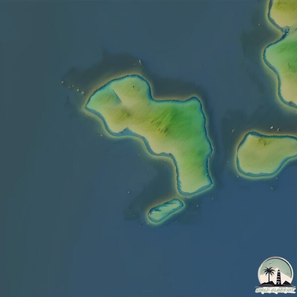
Geography and size of Île de Gargalo
Size: 0.209 km²
Coastline: 2.6 km
Ocean: Atlantic Ocean
Sea: Mediterranean Sea – Western Basin
Continent: Europe
Île de Gargalo is a Tiny Island spanning 0.209 km² with a coastline of 2.6 km.
Archipel: Mediterranean islands – Encompassing numerous islands in the Mediterranean Sea, each with its own unique culture, history, and natural beauty, from the Balearics to the Greek islands.
Tectonic Plate: Eurasia – One of the world’s largest tectonic plates, the Eurasian Plate covers a significant portion of Europe and Asia. It’s characterized by diverse geological features, including the Ural Mountains, the European Plain, and the Himalayas formed from its collision with the Indian Plate.
The geographic heart of the island is pinpointed at these coordinates:
Latitude: 42.36954391 / Longitude: 8.53947163
Climate and weather of Île de Gargalo
Climate Zone: Temperate
Climate Details: Hot-Summer Mediterranean Climate
Temperature: Hot Summer
Climate Characteristics: Characterized by hot, dry summers and mild, wet winters, typical of coastal areas with abundant sunshine.
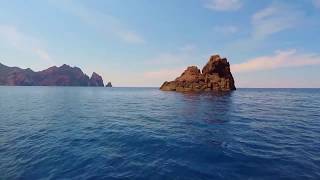
Topography and nature of Île de Gargalo
Timezone: UTC+01:00
Timezone places: Europe/Paris
Max. Elevation: 56 m
Mean Elevation: -5 m
Vegetation: Open Woodland
Tree Coverage: 91%
The mean elevation is -5 m. The highest elevation on the island reaches approximately 56 meters above sea level. The island is characterized by Plains: Flat, low-lying lands characterized by a maximum elevation of up to 200 meters. On islands, plains are typically coastal lowlands or central flat areas.
Dominating Vegetation: Open Woodland
Characterized by sparsely distributed trees with open canopy allowing sunlight to penetrate, supporting grasses and shrubs underneath. Often found in drier or transitional environments. Île de Gargalo has a tree cover of 91 %.
Vegetation: 2 vegetation zones – Low Diversity Island
Islands with two distinct vegetation zones offer slightly more ecological variety. These zones could be due to differences in elevation, moisture, or other environmental factors. While still limited in biodiversity, these islands may offer a contrast between the two zones, such as a coastline with mangroves and an inland area with grassland.
Infrastructure and Travelling to Île de Gargalo
Does the island have a public airport? no.
There is no public and scheduled airport on Île de Gargalo. The nearest airport is Calvi-Sainte-Catherine Airport, located 33 km away.
Does the island have a major port? no.
There are no major ports on Île de Gargalo. The closest major port is CALVI, approximately 32 km away.
The mean population of Île de Gargalo is 3 per km². Île de Gargalo is Gently Populated. The island belongs to France.
The name of the island resonates across different cultures and languages. Here is how it is known around the world: Arabic: قرسقة; German: Korsika; Spanish: Córcega; French: Corse; Portuguese: Córsega; Russian: Корсика; Chinese: 科西嘉
Continuing your journey, Corsica is the next notable island, situated merely km away.
Tour de Gargali

France is classified as Developed region: G7: Group of Seven – Major advanced economies, including Canada, France, Germany, Italy, Japan, the United Kingdom, and the United States. The level of income is High income: OECD.
News – Latest Updates and Headlines from Île de Gargalo
Stay informed with the most recent news and important headlines from Île de Gargalo. Here’s a roundup of the latest developments.
Please note: The data used here has been primarily extracted from satellite readings. Deviations from exact values may occur, particularly regarding the height of elevations and population density. Land area and coastline measurements refer to average values at mean high tide.