Île de la Gonâve

Welcome to Île de la Gonâve, a Tropical island in the Caribbean Sea, part of the majestic Atlantic Ocean. This guide offers a comprehensive overview of what makes Île de la Gonâve unique – from its geography and climate to its population, infrastructure, and beyond. Dive into the details:
- Geography and Size: Explore the island’s size and location.
- Climate and Weather: Weather patterns and temperature.
- Topography and Nature: Uncover the natural wonders of the island.
- Infrastructure and Travelling: Insights on reaching, staying, and making the most of your visit.
- News and Headlines: Latest News.
Geography and size of Île de la Gonâve
Size: 685.6 km²
Coastline: 149.4 km
Ocean: Atlantic Ocean
Sea: Caribbean Sea
Continent: North America
Île de la Gonâve is a Large Island spanning 686 km² with a coastline of 149 km.
Archipel: Greater Antilles – A major island group in the Caribbean, including Cuba, Jamaica, Hispaniola, and Puerto Rico, known for their rich history and diverse cultures.
Tectonic Plate: North America – Covers North America and parts of the Atlantic and Arctic Oceans, characterized by diverse geological features and varying levels of seismic activity.
The geographic heart of the island is pinpointed at these coordinates:
Latitude: 18.84267278 / Longitude: -73.04605971
Climate and weather of Île de la Gonâve
Climate Zone: Tropical
Climate Details: Tropical Savanna, Wet
Temperature: Hot
Climate Characteristics: Defined by distinct wet and dry seasons with high temperatures year-round. Pronounced rainfall occurs during the wet season, while the dry season is marked by drought.
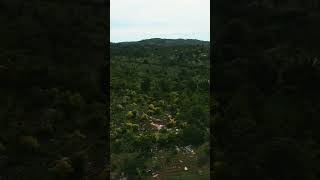
Topography and nature of Île de la Gonâve
Timezone: UTC-05:00
Timezone places: America/New_York
Max. Elevation: 746 m
Mean Elevation: 218 m
Vegetation: Agricultural Mosaic
Tree Coverage: 23%
The mean elevation is 218 m. The highest elevation on the island reaches approximately 746 meters above sea level. The island is characterized by Plateau: Elevated flatlands rising sharply above the surrounding area, with a maximum elevation over 500 meters but a mean elevation less than 300 meters, forming unique highland areas on islands.
Dominating Vegetation: Agricultural Mosaic
A mix of cropland and natural vegetation, often seen in rural landscapes where agricultural fields are interspersed with patches of natural habitats. Île de la Gonâve has a tree cover of 23 %.
Vegetation: 13 vegetation zones – Exceptionally Diverse Island
Islands with more than ten vegetation zones are among the most ecologically rich and varied in the world. These islands are akin to miniature continents, boasting an incredible array of ecosystems. The sheer range of habitats, from high peaks to deep valleys, rainforests to deserts, creates a mosaic of life that is unparalleled. They are crucial for conservation and ecological studies.
Infrastructure and Travelling to Île de la Gonâve
Does the island have a public airport? no.
There is no public and scheduled airport on Île de la Gonâve. The nearest airport is Toussaint Louverture International Airport, located 58 km away.
Does the island have a major port? no.
There are no major ports on Île de la Gonâve. The closest major port is PETIT GOAVE, approximately 29 km away.
The mean population of Île de la Gonâve is 589 per km². Île de la Gonâve is Densely Populated. The island belongs to Haiti.
The name of the island resonates across different cultures and languages. Here is how it is known around the world: Arabic: هيسبانيولا; German: Hispaniola; Spanish: La Española; French: Hispaniola; Portuguese: Ilha de São Domingos; Russian: Гаити; Chinese: 伊斯帕尼奥拉岛
Continuing your journey, Grande Cayemite is the next notable island, situated merely km away.
Haiti Earthship Update from La Gonave


Haiti is classified as Least developed region: Countries that exhibit the lowest indicators of socioeconomic development, with the lowest Human Development Index ratings. The level of income is Low income.
News – Latest Updates and Headlines from Île de la Gonâve
Stay informed with the most recent news and important headlines from Île de la Gonâve. Here’s a roundup of the latest developments.
Please note: The data used here has been primarily extracted from satellite readings. Deviations from exact values may occur, particularly regarding the height of elevations and population density. Land area and coastline measurements refer to average values at mean high tide.