Welcome to Île de la Jument, a Temperate island in the Bay of Biscay, part of the majestic Atlantic Ocean. This guide offers a comprehensive overview of what makes Île de la Jument unique – from its geography and climate to its population, infrastructure, and beyond. Dive into the details:
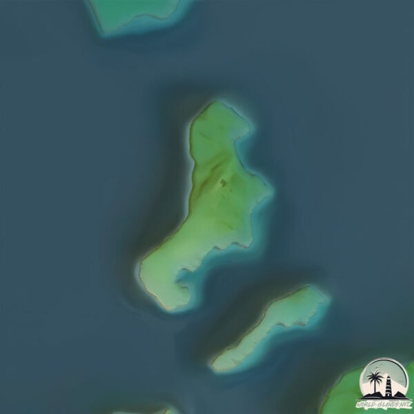
Geography and size of Île de la Jument
Size: 0.132 km²
Coastline: 1.9 km
Ocean: Atlantic Ocean
Sea: Bay of Biscay
Continent: Europe
Île de la Jument is a Tiny Island spanning 0.132 km² with a coastline of 1.9 km.
Archipel: –
Tectonic Plate: Eurasia – One of the world’s largest tectonic plates, the Eurasian Plate covers a significant portion of Europe and Asia. It’s characterized by diverse geological features, including the Ural Mountains, the European Plain, and the Himalayas formed from its collision with the Indian Plate.
The geographic heart of the island is pinpointed at these coordinates:
Latitude: 47.56841798 / Longitude: -2.88784757
Climate and weather of Île de la Jument
Climate Zone: Temperate
Climate Details: Temperate Oceanic Climate
Temperature: Warm Summer
Climate Characteristics: Known for its moderate year-round temperatures with ample rainfall and no dry season. Warm summers are characteristic.
Topography and nature of Île de la Jument
Timezone: UTC+01:00
Timezone places: Europe/Paris
Max. Elevation: 1 m
Mean Elevation: 1 m
Vegetation: Evergreen Needleleaf Forest
Tree Coverage: 30%
The mean elevation is 1 m. The highest elevation on the island reaches approximately 1 meters above sea level. The island is characterized by Plains: Flat, low-lying lands characterized by a maximum elevation of up to 200 meters. On islands, plains are typically coastal lowlands or central flat areas.
Dominating Vegetation: Evergreen Needleleaf Forest
Dominated by evergreen coniferous trees such as pines and firs, which retain their needle-like leaves throughout the year. These forests are often found in cooler climates. Île de la Jument has a tree cover of 30 %.
Vegetation: 2 vegetation zones – Low Diversity Island
Islands with two distinct vegetation zones offer slightly more ecological variety. These zones could be due to differences in elevation, moisture, or other environmental factors. While still limited in biodiversity, these islands may offer a contrast between the two zones, such as a coastline with mangroves and an inland area with grassland.
Infrastructure and Travelling to Île de la Jument
Does the island have a public airport? no.
There is no public and scheduled airport on Île de la Jument. The nearest airport is Lorient South Brittany (Bretagne Sud) Airport, located 65 km away.
Does the island have a major port? no.
There are no major ports on Île de la Jument. The closest major port is LORIENT, approximately 55 km away.
The mean population of Île de la Jument is 226 per km². Île de la Jument is Moderately Inhabited. The island belongs to France.
Continuing your journey, Belle-Île-en-Mer is the next notable island, situated merely km away.
THE WORLD'S MOST DANGEROUS LIGHTHOUSE: LA JUMENT! #legend #ocean #lighthouse #rescue #wave #facts
THE WORLD'S MOST DANGEROUS LIGHTHOUSE: LA JUMENT! #legend #ocean #lighthouse #rescue #wave #facts
Why can't a tsunami also defeat the lighthouse?
shorts #short #shortvideo #shortestfacts #building #explore #funfacts ...
shorts #short #shortvideo #shortestfacts #building #explore #funfacts #knowledge #technology #science #world #discovery ...
La Jument Lighthouse Legacy | Mystery Keeping Job | Death Warrant
"The History Behind La Jument Lighthouse" La Jument Lighthouse was ...
"The History Behind La Jument Lighthouse" La Jument Lighthouse was built in response to several shipwrecks and maritime ...
Lighthouse of "La Jument" - Phare de "La Jument"
Lighthouse of "la Jument" and the guard Theodore Malgorne, in the ...
Lighthouse of "la Jument" and the guard Theodore Malgorne, in the storm. Erected on a stone called la Jument, "Ar-Gazec" in ...
Amazing Quest: Stories from Brittany | Somewhere on Earth: Brittany | Free Documentary
Somewhere on Earth - Brittany | Free Documentary Somewhere on Earth - ...
Overnight in the World's Loneliest House
today I explore the loneliest house in the world. coolest experience ...
today I explore the loneliest house in the world. coolest experience of my life contact ragnar:
ragnarjohann@gmail.com 24 ...
Courant de l'île de la Jument
Voyage en Zodiac dans le Golfe.
Voyage en Zodiac dans le Golfe.
Le courant de la Jument au jusant vu depuis la pointe Sud de l'île Berder (2/2) - Le 20 avril 2017
On dit de lui qu'il est le 2ème courant le plus fort d'Europe. ...
On dit de lui qu'il est le 2ème courant le plus fort d'Europe. L'entrée et la sortie du golfe étant relativement étroite (900 mètres) au ...
TEMPETE Eunice FORCE 11 à OUESSANT - BRETAGNE - 4K
Mathieu Rivrin - Reproduction Interdite Licensing : ...
Discovery : Île de la Jument - Port Navalo (03/05/2025)
Golfe du Morbihan avec la SNTM et le PSUC. Île de la Jument - Port ...
Golfe du Morbihan avec la SNTM et le PSUC. Île de la Jument - Port Navalo Les photos (à venir) : Edition Mai 2025 ...
C’est la plus belle île du golfe du Morbihan ! #pourtoi #nature #naturelovers
Ouessant, le soir tombe sur le phare de la Jument
"Laissant l'île seule", haïku de Jonas Dagorn. Écriture et ...
"Laissant l'île seule", haïku de Jonas Dagorn. Écriture et réalisation, Juillet 2019. D'autres vidéos, haïku et notes sur ...
vidéo du courant de la Jument - île Berder - Bretagne
2ème courant maritime le + fort d'Europe.Il peut dépasser les 9,1 ...
2ème courant maritime le + fort d'Europe.Il peut dépasser les 9,1 noeuds !!!! Il se situe entre l'île Berder et l'ïle de la Jument dans ...
Le courant de la jument et l'île de Berder
Le courant de la jument et un bateau qui remonte.
Le courant de la jument et un bateau qui remonte.
Ouessant, l'île sauvage bretonne - Thalassa
La Jument lighthouse in France would be a terrifying visit !
Le phare du Four en Bretagne est juste 😍
Phare du Four Quand une tempête déferlait au large de la presqu'île ...
Phare du Four Quand une tempête déferlait au large de la presqu'île Saint-Laurent sur ce phare de 31m de haut ...
le courant de la Jument, l'île de Berder
Une vidéo du courant de la jument où l'on voit un Sinagot descendre le ...
Une vidéo du courant de la jument où l'on voit un Sinagot descendre le courant.
Escape 4 L'île d'Ouessant et ces Phares : phares du Créac'h, de la Jument de Nividic
L'île d'Ouessant en Finistère, découvrez les phares du Créac'h, de la ...
L'île d'Ouessant en Finistère, découvrez les phares du Créac'h, de la Jument et de Nividic Musiques : Gwendal - Glen River ...
Tempête en Bretagne : la mer démontée dans 'l'enfer des enfers' au large de l'île de Sein
La tempête en Bretagne a provoqué une forte houle au large, en ...
La tempête en Bretagne a provoqué une forte houle au large, en témoignent ces images aériennes filmées au-dessus du phare ...
Sur l'île de Berder (3/3) - Vue sur le courant de la Jument au jusant - Le 20 avril 2017
Vidéo prise avec un Nikon Coolpix P500. Il était 20h22.
Vidéo prise avec un Nikon Coolpix P500. Il était 20h22.
Le courant de la Jument au jusant vu depuis la pointe Sud de l'île Berder (1/2) - Le 20 avril 2017
On dit de lui qu'il est le 2ème courant le plus fort d'Europe. ...
On dit de lui qu'il est le 2ème courant le plus fort d'Europe. L'entrée et la sortie du golfe étant relativement étroite (900 mètres) au ...
Expectation VS Reality : Tenerife 🇮🇨
Retrouvez notre collection de vêtements & accessoires équestres sur : ...
The Unsolved Mystery of the Flannan Isle Lighthouse [Part 1] #shorts
SCARY Lighthouse in the world #LaJument #Phare de La Jument
Lighthouse of "la Jument" and the guard Theodore Malgorne, in the ...
Lighthouse of "la Jument" and the guard Theodore Malgorne, in the storm. Erected on a stone called la Jument, "Ar-Gazec" in ...
France is classified as Developed region: G7: Group of Seven – Major advanced economies, including Canada, France, Germany, Italy, Japan, the United Kingdom, and the United States. The level of income is High income: OECD.
News – Latest Updates and Headlines from Île de la Jument
Stay informed with the most recent news and important headlines from Île de la Jument. Here’s a roundup of the latest developments.
Loading...
Please note: The data used here has been primarily extracted from satellite readings. Deviations from exact values may occur, particularly regarding the height of elevations and population density. Land area and coastline measurements refer to average values at mean high tide.


![The Unsolved Mystery of the Flannan Isle Lighthouse [Part 1] #shorts](https://i.ytimg.com/vi/iHzxsyyCAs4/mqdefault.jpg)
