Île de Riou
Welcome to Île de Riou, a Temperate island in the Mediterranean Sea – Western Basin, part of the majestic Atlantic Ocean. This guide offers a comprehensive overview of what makes Île de Riou unique – from its geography and climate to its population, infrastructure, and beyond. Dive into the details:
- Geography and Size: Explore the island’s size and location.
- Climate and Weather: Weather patterns and temperature.
- Topography and Nature: Uncover the natural wonders of the island.
- Infrastructure and Travelling: Insights on reaching, staying, and making the most of your visit.
- News and Headlines: Latest News.
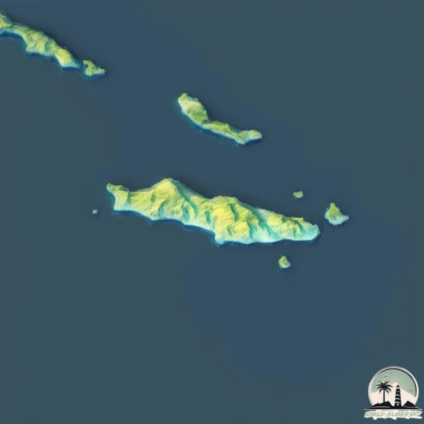
Geography and size of Île de Riou
Size: 0.962 km²
Coastline: 5.5 km
Ocean: Atlantic Ocean
Sea: Mediterranean Sea – Western Basin
Continent: Europe
Île de Riou is a Tiny Island spanning 0.962 km² with a coastline of 5.5 km.
Archipel: –
Tectonic Plate: Eurasia – One of the world’s largest tectonic plates, the Eurasian Plate covers a significant portion of Europe and Asia. It’s characterized by diverse geological features, including the Ural Mountains, the European Plain, and the Himalayas formed from its collision with the Indian Plate.
The geographic heart of the island is pinpointed at these coordinates:
Latitude: 43.1761823 / Longitude: 5.38522093
Climate and weather of Île de Riou
Climate Zone: Temperate
Climate Details: Hot-Summer Mediterranean Climate
Temperature: Hot Summer
Climate Characteristics: Characterized by hot, dry summers and mild, wet winters, typical of coastal areas with abundant sunshine.
Topography and nature of Île de Riou
Timezone: UTC+01:00
Timezone places: Europe/Paris
Max. Elevation: 20 m
Mean Elevation: -10 m
Vegetation: Sparse Vegetation
Tree Coverage: 33%
The mean elevation is -10 m. The highest elevation on the island reaches approximately 20 meters above sea level. The island is characterized by Plains: Flat, low-lying lands characterized by a maximum elevation of up to 200 meters. On islands, plains are typically coastal lowlands or central flat areas.
Dominating Vegetation: Sparse Vegetation
These regions have limited plant growth, typically due to extreme conditions like aridity or poor soils. Vegetation is scattered and consists of hardy plant species. Île de Riou has a tree cover of 33 %.
Vegetation: 4 vegetation zones – Diverse Island
Four distinct vegetation zones mark these islands as ecologically diverse. They might feature varied landscapes such as forests, beaches, grasslands, and rocky areas. Such diversity reflects the island’s complex ecological interactions and varied habitats, which can support a rich array of wildlife and plant species.
Infrastructure and Travelling to Île de Riou
Does the island have a public airport? no.
There is no public and scheduled airport on Île de Riou. The nearest airport is Marseille Provence Airport, located 33 km away.
Does the island have a major port? no.
There are no major ports on Île de Riou. The closest major port is MARSEILLE, approximately 15 km away.
The mean population of Île de Riou is 3460 per km². Île de Riou is Densely Populated. The island belongs to France.
Continuing your journey, Île de Porquerolles is the next notable island, situated merely km away.
Calanques - Ep4 - SUP to Riou Islands


France is classified as Developed region: G7: Group of Seven – Major advanced economies, including Canada, France, Germany, Italy, Japan, the United Kingdom, and the United States. The level of income is High income: OECD.
News – Latest Updates and Headlines from Île de Riou
Stay informed with the most recent news and important headlines from Île de Riou. Here’s a roundup of the latest developments.
Please note: The data used here has been primarily extracted from satellite readings. Deviations from exact values may occur, particularly regarding the height of elevations and population density. Land area and coastline measurements refer to average values at mean high tide.