Welcome to Île d’Entrée, a Continental island in the Gulf of St. Lawrence, part of the majestic Atlantic Ocean. This guide offers a comprehensive overview of what makes Île d’Entrée unique – from its geography and climate to its population, infrastructure, and beyond. Dive into the details:
Geography and size of Île d’Entrée
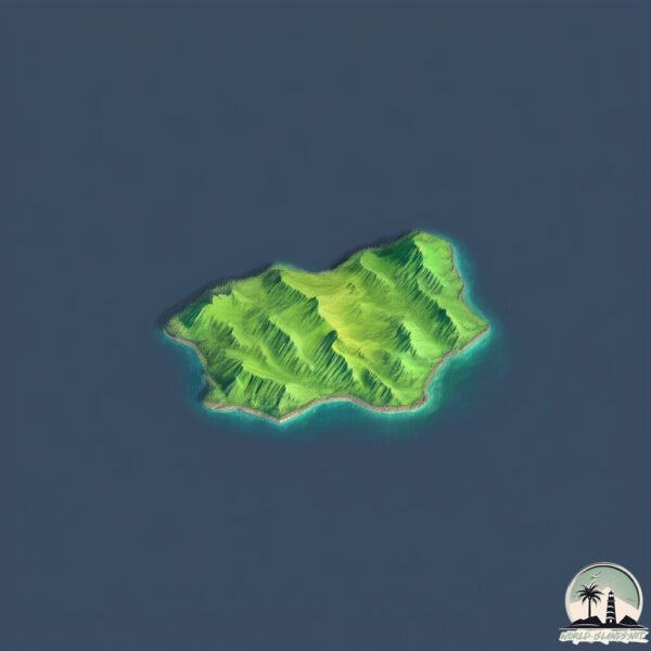
Size: 4.074 km²
Coastline: 9.5 km
Ocean: Atlantic Ocean
Sea: Gulf of St. Lawrence
Continent: North America
Île d’Entrée is a Small Island spanning 4.1 km² with a coastline of 9.5 km.
Archipel: –
Tectonic Plate: Eurasia – One of the world’s largest tectonic plates, the Eurasian Plate covers a significant portion of Europe and Asia. It’s characterized by diverse geological features, including the Ural Mountains, the European Plain, and the Himalayas formed from its collision with the Indian Plate.
The geographic heart of the island is pinpointed at these coordinates:
Latitude: 47.27700701 / Longitude: -61.69978957
Climate and weather of Île d’Entrée
Climate Zone: Continental
Climate Details: Warm-Summer Humid Continental Climate
Temperature: Warm Summer
Climate Characteristics: Features warm summers and cold winters with consistent precipitation, common in higher latitudes.
Topography and nature of Île d’Entrée
Timezone: UTC-05:00
Timezone places: America/New_York
Max. Elevation: 91 m
Mean Elevation: 36 m
Vegetation: Mixed Forest
Tree Coverage: 48%
The mean elevation is 36 m. The highest elevation on the island reaches approximately 91 meters above sea level. The island is characterized by Plains: Flat, low-lying lands characterized by a maximum elevation of up to 200 meters. On islands, plains are typically coastal lowlands or central flat areas.
Dominating Vegetation: Mixed Forest
A combination of both deciduous and evergreen trees, often found in transitional zones between forest types. These forests offer a diverse habitat for various wildlife species. Île d’Entrée has a tree cover of 48 %.
Vegetation: 5 vegetation zones – Highly Diverse Island
With five different vegetation zones, these islands offer a rich tapestry of ecosystems. The variety could include dense forests, open meadows, wetlands, coastal zones, and more. This level of diversity supports an intricate web of life, with each zone playing a vital role in the overall ecological health and balance of the island.
Infrastructure and Travelling to Île d’Entrée
Does the island have a public airport? no.
There is no public and scheduled airport on Île d’Entrée. The nearest airport is Îles-de-la-Madeleine Airport, located 17 km away.
Does the island have a major port? no.
There are no major ports on Île d’Entrée. The closest major port is GEORGETOWN, approximately 151 km away.
The mean population of Île d’Entrée is 27 per km². Île d’Entrée is Gently Populated. The island belongs to Canada.
Continuing your journey, Magdalen is the next notable island, situated merely km away.
On découvre l'Île d'Entrée - Îles-de-la-Madeleine
On embarque à bord du Bôp' ti-Bötte, le bateau de notre ami Serge en direction de l'Île d'Entrée! Cette île mystérieuse où la ...On découvre l'Île d'Entrée - Îles-de-la-Madeleine
On embarque à bord du Bôp' ti-Bötte, le bateau de notre ami Serge en ...
On embarque à bord du Bôp' ti-Bötte, le bateau de notre ami Serge en direction de l'Île d'Entrée! Cette île mystérieuse où la ...
Entry Island
Miscellaneous images of Entry Island on a sunny day.
Miscellaneous images of Entry Island on a sunny day.
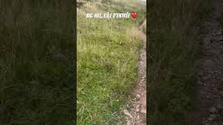
Big Hill | Île d’Entrée - Îles-de-la-Madeleine
RANDONNÉE SUR LA BUTTE BIG HILL - ÎLE D'ENTRÉE - ILES DE LA MADELEINE
Randonnée sur la butte Big Hill - Île d'Entrée - Iles de la Madeleine ...
Randonnée sur la butte Big Hill - Île d'Entrée - Iles de la Madeleine Coordonnées GPS: 47°16'37.7"N 61°42'58.8"W Après avoir ...
Most Beautiful Beach In Canada? Îles-de-la-Madeleine Is A Dream. #Quebec #travelvlog #travelblogger
Ile d'entrée
description.
description.
Vivre de la mer: L'île d'entrée
Toute petite et dénudée, l'Île d'Entrée est la seule île encore ...
Toute petite et dénudée, l'Île d'Entrée est la seule île encore habitée qui n'est pas reliée au reste de l'archipel des ...
Ile d'entrée Ile de la Madeleine 2013
J'ai créé cette vidéo à l'aide de l'application de montage de vidéos ...
Îles-de-la-Madeleine: grandeur et décadence | HNLD Découvrir le Québec # 2
La première fois que je suis allé aux îles de la Madeleine, j'ai, ...
La première fois que je suis allé aux îles de la Madeleine, j'ai, comme on dit, « pogné de quoi », mais plus encore, après mon ...
île D'Entrêe Quebec Canada Western Atlantic in Google Earth and Google Maps #google #viral #reels
Western Atlantic Ìîle D'Entrêe Quebec Canada in Google Earth and ...
Western Atlantic Ìîle D'Entrêe Quebec Canada in Google Earth and Google Maps #google #viral #reels.
TOP 9 ÎLES MALAISIE 2025 - Quelles sont les meilleures plages ?
Pour toutes les demandes personnalisées, ou pour toute aide et ...
Pour toutes les demandes personnalisées, ou pour toute aide et accompagnement pour créer votre voyage en Malaisie sur ...
Sentiers Entre Vents et Marées aux Îles de la Madeleine (version complète)
Bienvenue sur les Sentiers Entre Vents et Marées aux Îles de la ...
Bienvenue sur les Sentiers Entre Vents et Marées aux Îles de la Madeleine ! Parcourez ces sentiers pittoresques qui serpentent à ...
Souvenir d'un après-midi à l'île d'Entrée
paysage de l'île d'Entrée.
paysage de l'île d'Entrée.
Les Îles de la Madeleine vu du ciel
Montage vidéo de prises de drône aux Îles-de-la-Madeleine plus mes ...
Montage vidéo de prises de drône aux Îles-de-la-Madeleine plus mes meilleures photographies de l'endroit, été 2018. Video ...
La Découverte Des Îles Françaises Dans L'océan Indien
La Découverte Des Îles Françaises Dans L'océan Indien Un SUPER THANKS ...
La Découverte Des Îles Françaises Dans L'océan Indien Un SUPER THANKS m'aide beaucoup à développer ma chaîne ...
Îles-de-la-Madeleine
Video avec drône des Îles-de-la-Madeleine.
Video avec drône des Îles-de-la-Madeleine.
Documentaire Polynésie Française : Les Secrets de Tahiti & ses îles
Ce documentaire vous emmène à la découverte de l'archipel de la ...
Ce documentaire vous emmène à la découverte de l'archipel de la Société, un ensemble d'îles paradisiaques au cœur de la ...
L'île la plus dangereuse du monde
Bienvenue à North Sentinel, un bout de terre d'une superficie de 60 km ...
Bienvenue à North Sentinel, un bout de terre d'une superficie de 60 km administrée par l'Inde et qui se trouve au large de la ...
GROTTE "LA CATHÉDRALE" - EXCURSIONS EN MER - ÎLE DE CAP AUX MEULES - ILES DE LA MADELEINE
Grotte "La Cathédrale" - Excursions en mer - Île de Cap aux Meules - ...
Grotte "La Cathédrale" - Excursions en mer - Île de Cap aux Meules - Iles de la Madeleine Au fil du temps, d'importantes grottes ...
Les Îles-de-la-Madeleine: Discovering Quebec's SECRET island paradise in the Gulf (Magdalen Islands)
Far off the coast of mainland Quebec lies a secretive and hidden ...
Far off the coast of mainland Quebec lies a secretive and hidden island paradise that is one of the true gems of La Belle Province.
Iles de la Madeleine / Magdalen Islands
Photos de l'archipel / Photos of the archipelago.
Photos de l'archipel / Photos of the archipelago.
Les Canaries : quelle île choisir ?
Retrouvez ce voyage avec les meilleurs bons plans du moment et le ...
Retrouvez ce voyage avec les meilleurs bons plans du moment et le guide Partir à personnaliser ...
ÎLE DE CAP AUX MEULES - ILES DE LA MADELEINE
Île de Cap Aux Meules - Iles de la Madeleine Coordonnées GPS: ...
Île de Cap Aux Meules - Iles de la Madeleine Coordonnées GPS: 47°22'39.8"N 61°52'17.2"W L'île de Cap aux Meules possède ...
Magdalen Islands: Unveiling the Enchanting Secrets of Quebec's Coastal Gem
The Magdalen Islands, also known as the Îles de la Madeleine, are a ...
The Magdalen Islands, also known as the Îles de la Madeleine, are a small archipelago located in the Gulf of Saint Lawrence off ...
Canada is classified as Developed region: G7: Group of Seven – Major advanced economies, including Canada, France, Germany, Italy, Japan, the United Kingdom, and the United States. The level of income is High income: OECD.
News – Latest Updates and Headlines from Île d’Entrée
Stay informed with the most recent news and important headlines from Île d’Entrée. Here’s a roundup of the latest developments.
Loading...
Please note: The data used here has been primarily extracted from satellite readings. Deviations from exact values may occur, particularly regarding the height of elevations and population density. Land area and coastline measurements refer to average values at mean high tide.