Welcome to Île des Cascades, a Continental island in the Gulf of St. Lawrence, part of the majestic Atlantic Ocean. This guide offers a comprehensive overview of what makes Île des Cascades unique – from its geography and climate to its population, infrastructure, and beyond. Dive into the details:
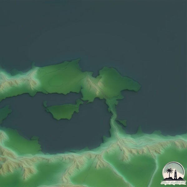
Geography and size of Île des Cascades
Size: 0.56 km²
Coastline: 5.7 km
Ocean: Atlantic Ocean
Sea: Gulf of St. Lawrence
Continent: North America
Île des Cascades is a Tiny Island spanning 0.56 km² with a coastline of 5.7 km.
Archipel: –
Tectonic Plate: North America – Covers North America and parts of the Atlantic and Arctic Oceans, characterized by diverse geological features and varying levels of seismic activity.
The geographic heart of the island is pinpointed at these coordinates:
Latitude: 45.32891807 / Longitude: -73.94718179
Climate and weather of Île des Cascades
Climate Zone: Continental
Climate Details: Hot-Summer Humid Continental Climate
Temperature: Hot Summer
Climate Characteristics: Hot summers with ample rainfall and cold winters, typical in the interiors of northern continents.
Topography and nature of Île des Cascades
Timezone: UTC-05:00
Timezone places: America/New_York
Max. Elevation: 25 m
Mean Elevation: 20 m
Vegetation: Urban Area
Tree Coverage: 63%
The mean elevation is 20 m. The highest elevation on the island reaches approximately 25 meters above sea level. The island is characterized by Plains: Flat, low-lying lands characterized by a maximum elevation of up to 200 meters. On islands, plains are typically coastal lowlands or central flat areas.
Dominating Vegetation: Urban Area
Regions dominated by human development, including cities and towns, characterized by buildings, roads, and minimal vegetation. Île des Cascades has a tree cover of 63 %.
Vegetation: 2 vegetation zones – Low Diversity Island
Islands with two distinct vegetation zones offer slightly more ecological variety. These zones could be due to differences in elevation, moisture, or other environmental factors. While still limited in biodiversity, these islands may offer a contrast between the two zones, such as a coastline with mangroves and an inland area with grassland.
Infrastructure and Travelling to Île des Cascades
Does the island have a public airport? no.
There is no public and scheduled airport on Île des Cascades. The nearest airport is Montreal / Pierre Elliott Trudeau International Airport, located 27 km away.
Does the island have a major port? no.
There are no major ports on Île des Cascades. The closest major port is BEAUHARNOIS, approximately 6 km away.
The mean population of Île des Cascades is 452 per km². Île des Cascades is Moderately Inhabited. The island belongs to Canada.
Continuing your journey, Bouchard is the next notable island, situated merely km away.
Anse des Cascades - Ile de la Réunion
Découvrez Anse des Cascades au sud est de l'Ile de la Réunion. Proche de l'océan, situé à côté d'un port de pêcheurs, vous y ...Anse des Cascades - Ile de la Réunion
Découvrez Anse des Cascades au sud est de l'Ile de la Réunion. Proche ...
Découvrez Anse des Cascades au sud est de l'Ile de la Réunion. Proche de l'océan, situé à côté d'un port de pêcheurs, vous y ...
ANSE DES CASCADES 🌴 - Île de la Réunion 🇷🇪 EN DRONE
On se retrouve à l'Anse des Cascades. Une Anse remplie de palmier et ...
On se retrouve à l'Anse des Cascades. Une Anse remplie de palmier et entourée de cascades ! Bon visionnage ! Musique ...
Waterfalls - Les cascades de l'île de la Réunion en drone
Île de la Réunion (Reunion island) -2017- Anse des cascades riche en eau vive (HD1080P)
Anse des Cascades se situe sur le territoire communal de Sainte-Rose ...
Anse des Cascades se situe sur le territoire communal de Sainte-Rose de l'île de la Réunion, plus précisément à Piton Sainte ...
Le site d' Anse des Cascades à l'île de la Réunion
Le charme du site d'Anse des Cascades au mois de septembre à l'île de ...
Le charme du site d'Anse des Cascades au mois de septembre à l'île de la Réunion en diaporama photos. Déjà + de 170 clips de ...
RANDO ILE DE LA REUNION 2020 L' ANSE DES CASCADES
RANDONNEE DANS L'EST DE L' ILE DE LA REUNION BOUCLE DE 18 KMS AU ...
RANDONNEE DANS L'EST DE L' ILE DE LA REUNION BOUCLE DE 18 KMS AU DEPART DE L'ANSE DES CASCADES VIA LA ...
Anse des Cascades - Ile de la Réunion
Anse des Cascades, l'un des plus beaux spot de la Réunion avec ses ...
Anse des Cascades, l'un des plus beaux spot de la Réunion avec ses cascades et son front de mer : vous aimez ?
Instants Nature à Anse des Cascades, île de la Réunion
Le charme de Anse des cascades,sa verdure et son ambiance unique, à ...
Le charme de Anse des cascades,sa verdure et son ambiance unique, à découvrir!!! Déjà + de 150 clips de diaporamas photos ...
Île de La Réunion - Anse des cascades
Suivez-nous sur la page Facebook de Vibrason ! ...
cascade langevin/langevin waterfall ( Île de la Réunion)
Anse des Cascades (ILE DE LA REUNION 974)
Anse des Cascades, la Réunion. L'Anse des Cascades se situe sur le ...
Anse des Cascades, la Réunion. L'Anse des Cascades se situe sur le territoire communal de Sainte-Rose de l'île de la Réunion, ...
anse des Cascades (île de la réunion)
Anse des cascades - Ile de la Reunion
Anse des cascades à l'île de la Réunion : ...
Don't Believe it Until You See it! Underwater Waterfall in Mauritius Island Will Shock You #shorts
Take a trip to Mauritius Island and explore an amazing underwater ...
Take a trip to Mauritius Island and explore an amazing underwater waterfall. This waterfall is sure to shock you, and it's a must-see ...
Escapade en Dominique, îles des caraibes. Cascade époustouflante
Voyage en Dominique au départ de la Martinique. Jour 1 : Scott head - ...
Voyage en Dominique au départ de la Martinique. Jour 1 : Scott head - snorkeling. Jour 2 : Boeri - Freshwater Lake - Middleham ...
Mes 10 INCONTOURNABLES de l'île de la Réunion
Waterfalls for days ! - L’île de la Réunion💦💦
cascades #waterfall #iledelareunion #laréunion #travel #voyage.
cascades #waterfall #iledelareunion #laréunion #travel #voyage.
Cascade qui se déverse vers la Mer 🤩 [Île de la Réunion]
Anse des Cascades 97439 Sainte Rose [🏝️ Île de la Réunion] Cascade à ...
Anse des Cascades 97439 Sainte Rose [🏝️ Île de la Réunion] Cascade à même pas 200m de la mer A visiter.
Cascade du Bassin de la Paix - Ile de la Réunion
Découvrez le bassin de la Paix et sa magnifique cascade à Saint Benoit ...
Découvrez le bassin de la Paix et sa magnifique cascade à Saint Benoit sur l'Ile de la Réunion Soutenir Cascades de France ...
#Cascade de Grand Galet, Ile de la Reunion :Island
Douce musique de relaxation, cascade de Grand Galet à Langevin, au sud ...
Douce musique de relaxation, cascade de Grand Galet à Langevin, au sud de l'île de la Réunion dans l'océan Indien. Une chute ...
Cascade Langevin - Île de la Réunion
Impressionante Cascade Langevin suite au cyclone Batsirai. 2 personnes ...
Impressionante Cascade Langevin suite au cyclone Batsirai. 2 personnes sous les trombes d'eau ! -- Dévcouvre ton île !
Iceland 4K - Scenic Relaxation Film with Calming Music
Iceland is one of the most scenic countries in the world. Enjoy this ...
Iceland is one of the most scenic countries in the world. Enjoy this 4K relaxation film across the Iceland's most beautiful regions.
Île de la Réunion, Cascade grand galet langevin 🇷🇪❤️
What Really Happened to Treasure Island’s Pirate Show
On the Las Vegas Strip, there's a pirate themed hotel called Treasure ...
On the Las Vegas Strip, there's a pirate themed hotel called Treasure Island. In 1993, Treasure Island staged a pirate battle and ...
#shorts #shortsvideo #youtubeshorts #cascade #iledelareunion #island #tropical #lareunion #974
CASCADE DELICE #bozpapane #fyp #fyptiktok #reuniontourisme #travel ...
CASCADE DELICE #bozpapane #fyp #fyptiktok #reuniontourisme #travel #travelvlog #video Abonne-toi pour suivre mon ...
Canada is classified as Developed region: G7: Group of Seven – Major advanced economies, including Canada, France, Germany, Italy, Japan, the United Kingdom, and the United States. The level of income is High income: OECD.
News – Latest Updates and Headlines from Île des Cascades
Stay informed with the most recent news and important headlines from Île des Cascades. Here’s a roundup of the latest developments.
Loading...
Please note: The data used here has been primarily extracted from satellite readings. Deviations from exact values may occur, particularly regarding the height of elevations and population density. Land area and coastline measurements refer to average values at mean high tide.


![Cascade qui se déverse vers la Mer 🤩 [Île de la Réunion]](https://i.ytimg.com/vi/UC2Iu2oDFWQ/mqdefault.jpg)


