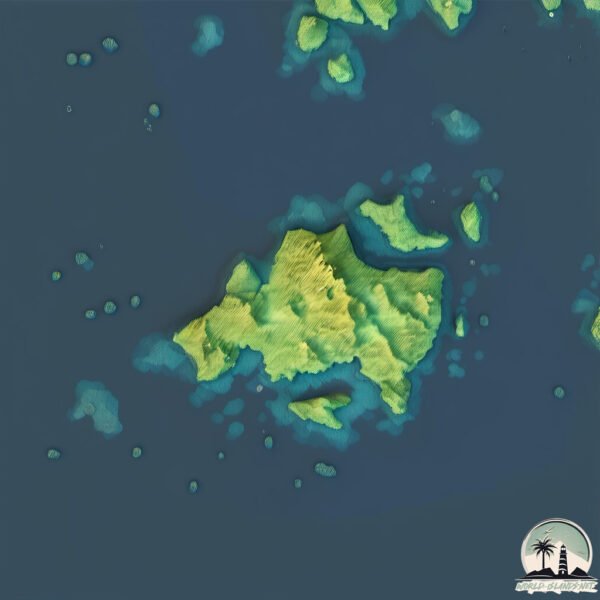
Île du Bassin
Welcome to Île du Bassin, a Continental island in the Gulf of St. Lawrence, part of the majestic Atlantic Ocean. This guide offers a comprehensive overview of what makes Île du Bassin unique – from its geography and climate to its population, infrastructure, and beyond. Dive into the details:
- Geography and Size: Explore the island’s size and location.
- Climate and Weather: Weather patterns and temperature.
- Topography and Nature: Uncover the natural wonders of the island.
- Infrastructure and Travelling: Insights on reaching, staying, and making the most of your visit.
- News and Headlines: Latest News.
Geography and size of Île du Bassin
Size: 2.411 km²
Coastline: 13.7 km
Ocean: Atlantic Ocean
Sea: Gulf of St. Lawrence
Continent: North America
Île du Bassin is a Small Island spanning 2.4 km² with a coastline of 13.7 km.
Archipel: –
Tectonic Plate: North America – Covers North America and parts of the Atlantic and Arctic Oceans, characterized by diverse geological features and varying levels of seismic activity.
The geographic heart of the island is pinpointed at these coordinates:
Latitude: 51.46026123 / Longitude: -57.27352814
Climate and weather of Île du Bassin
Climate Zone: Continental
Climate Details: Subarctic Climate
Temperature: Cold Summer
Climate Characteristics: Characterized by long, extremely cold winters and short, cool summers, often found in northern latitudes of North America and Eurasia.
Topography and nature of Île du Bassin
Timezone: UTC-04:00
Timezone places: America/La_Paz
Max. Elevation: 5 m
Mean Elevation: 1 m
Vegetation: Wetland
Tree Coverage: 93%
The mean elevation is 1 m. The highest elevation on the island reaches approximately 5 meters above sea level. The island is characterized by Plains: Flat, low-lying lands characterized by a maximum elevation of up to 200 meters. On islands, plains are typically coastal lowlands or central flat areas.
Dominating Vegetation: Wetland
These areas are saturated with water, either permanently or seasonally, and support aquatic plants. Wetlands are important for biodiversity and water filtration. Île du Bassin has a tree cover of 93 %.
Vegetation: 4 vegetation zones – Diverse Island
Four distinct vegetation zones mark these islands as ecologically diverse. They might feature varied landscapes such as forests, beaches, grasslands, and rocky areas. Such diversity reflects the island’s complex ecological interactions and varied habitats, which can support a rich array of wildlife and plant species.
Infrastructure and Travelling to Île du Bassin
Does the island have a public airport? no.
There is no public and scheduled airport on Île du Bassin. The nearest airport is Lourdes-de-Blanc-Sablon Airport, located 9 km away.
Does the island have a major port? no.
There are no major ports on Île du Bassin. The closest major port is BLANC SABLON, approximately 15 km away.
The mean population of Île du Bassin is 2 per km². Île du Bassin is Gently Populated. The island belongs to Canada.
Continuing your journey, Île des Esquimaux is the next notable island, situated merely km away.
PLAGE DU BASSIN EST ET SES PHOQUES - ÎLE DE GRANDE ENTRÉE - ÎLES DE LA MADELEINE

Canada is classified as Developed region: G7: Group of Seven – Major advanced economies, including Canada, France, Germany, Italy, Japan, the United Kingdom, and the United States. The level of income is High income: OECD.
News – Latest Updates and Headlines from Île du Bassin
Stay informed with the most recent news and important headlines from Île du Bassin. Here’s a roundup of the latest developments.
Please note: The data used here has been primarily extracted from satellite readings. Deviations from exact values may occur, particularly regarding the height of elevations and population density. Land area and coastline measurements refer to average values at mean high tide.