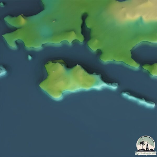
Welcome to Île en Dos de Cheval, a Continental island in the Gulf of St. Lawrence, part of the majestic Atlantic Ocean. This guide offers a comprehensive overview of what makes Île en Dos de Cheval unique – from its geography and climate to its population, infrastructure, and beyond. Dive into the details:
Geography and size of Île en Dos de Cheval
Size: 0.268 km²
Coastline: 2.6 km
Ocean: Atlantic Ocean
Sea: Gulf of St. Lawrence
Continent: North America
Île en Dos de Cheval is a Tiny Island spanning 0.268 km² with a coastline of 2.6 km.
Archipel: –
Tectonic Plate: North America – Covers North America and parts of the Atlantic and Arctic Oceans, characterized by diverse geological features and varying levels of seismic activity.
The geographic heart of the island is pinpointed at these coordinates:
Latitude: 50.20893333 / Longitude: -60.68378642
Climate and weather of Île en Dos de Cheval
Climate Zone: Continental
Climate Details: Warm-Summer Humid Continental Climate
Temperature: Warm Summer
Climate Characteristics: Features warm summers and cold winters with consistent precipitation, common in higher latitudes.
Topography and nature of Île en Dos de Cheval
Timezone: UTC-04:00
Timezone places: America/La_Paz
Max. Elevation: 3 m
Mean Elevation: -1 m
Vegetation: Deciduous Needleleaf Forest
Tree Coverage: 92%
The mean elevation is -1 m. The highest elevation on the island reaches approximately 3 meters above sea level. The island is characterized by Plains: Flat, low-lying lands characterized by a maximum elevation of up to 200 meters. On islands, plains are typically coastal lowlands or central flat areas.
Dominating Vegetation: Deciduous Needleleaf Forest
Consists of needleleaf trees that shed their needles annually. This type of forest is less common and can be found in certain cold, northern regions. Île en Dos de Cheval has a tree cover of 92 %.
Vegetation: 2 vegetation zones – Low Diversity Island
Islands with two distinct vegetation zones offer slightly more ecological variety. These zones could be due to differences in elevation, moisture, or other environmental factors. While still limited in biodiversity, these islands may offer a contrast between the two zones, such as a coastline with mangroves and an inland area with grassland.
Infrastructure and Travelling to Île en Dos de Cheval
Does the island have a public airport? no.
There is no public and scheduled airport on Île en Dos de Cheval. The nearest airport is Chevery Airport, located 119 km away.
Does the island have a major port? no.
There are no major ports on Île en Dos de Cheval. The closest major port is STEPHENVILLE, approximately 302 km away.
The mean population of Île en Dos de Cheval is 38 per km². Île en Dos de Cheval is Gently Populated. The island belongs to Canada.
Continuing your journey, Île du Petit Mécatina is the next notable island, situated merely km away.
Islande sauvage : une île sous haute protection
Entre volcans, glaciers, fjords, sources chaudes et falaises battues par les vents, l'Islande dévoile une nature spectaculaire ...Islande sauvage : une île sous haute protection
Entre volcans, glaciers, fjords, sources chaudes et falaises battues ...
Entre volcans, glaciers, fjords, sources chaudes et falaises battues par les vents, l'Islande dévoile une nature spectaculaire ...
The Island Ruled by Wild Horses 🐎
Sable Island is one of the most mysterious places in Canada. Home to ...
Sable Island is one of the most mysterious places in Canada. Home to over 400 wild horses, this remote island has no permanent ...
When you sell all your horses.. 🙈 | Wild horse islands! | #whi #roblox
Sable Island Horses: Resistance and Survival in a Safe Environment #horses #animals #animal
Sable Island: The Enigmatic Home of Wild Horses Nestled in the ...
Sable Island: The Enigmatic Home of Wild Horses Nestled in the Atlantic Ocean, approximately 300 kilometers southeast of ...
Sur l'île la plus isolée du monde, le cheval est roi
3700 habitants et presque autant de chevaux. Un mystère de plus pour ...
3700 habitants et presque autant de chevaux. Un mystère de plus pour le morceau de terre le plus isolé du monde. À l'ombre des ...
Comment Accéder a l'île Submergé sur Blox Fruit ?
Salut à tous et bienvenue dans cette nouvelle vidéo ! Merci d'être là, ...
Salut à tous et bienvenue dans cette nouvelle vidéo ! Merci d'être là, ça fait super plaisir de partager ça avec vous. Ici, on se ...
Sable Island - a Ilha dos cavalos
Sable Island - a Ilha dos cavalos.
Sable Island - a Ilha dos cavalos.
Découvrez la Réserve de parc national de l’Île-de-Sable
Au large, dans l'Atlantique Nord, se trouve la réserve de parc ...
Au large, dans l'Atlantique Nord, se trouve la réserve de parc national de l'Île-de-Sable, une île sablonneuse sauvage balayée ...
Hidden HORSE ISLAND 🏝️ Full of WILD Horses!
There's an island in Maryland that is full of wild horses where you ...
There's an island in Maryland that is full of wild horses where you can actually go and camp on the island with the horses! #horses ...
CHEVAL BLANC MALDIVES | Fabulous luxury resort (full tour in 4K)
Join me on a full tour of Cheval Blanc Randheli Maldives, one of the ...
Join me on a full tour of Cheval Blanc Randheli Maldives, one of the most luxurious private island resorts in the Maldives. Cheval ...
Cheval Blanc St Barth | Most expensive luxury hotel in the Caribbean (full tour in 4K)
Join me on a full 4K tour of Cheval Blanc St Barth, an ultra-exclusive ...
Join me on a full 4K tour of Cheval Blanc St Barth, an ultra-exclusive 5-star hotel on the Caribbean island of St Barts. Located on ...
Discover the Fascinating Geography of the Island Horses #horses #animals #animal #farming
Sable Island: The Enigmatic Home of Wild Horses Nestled in the ...
Sable Island: The Enigmatic Home of Wild Horses Nestled in the Atlantic Ocean, approximately 300 kilometers southeast of ...
It was sadly not what I expected 😢 #seychelles #island #adventuretravel
Wild Horse Islands summer event code! #roblox #wildhorseislands #shorts
How to get rope in Wild Horse Islands #roblox
fyp #roblox #horse #shorts.
fyp #roblox #horse #shorts.
Besoin de voyage au soleil ? Bienvenue à Djerba, l’île aux mille merveilles, entre mer et désert.
Imaginez une île baignée de lumière, bercée par la Méditerranée, où ...
Imaginez une île baignée de lumière, bercée par la Méditerranée, où les traditions se mêlent à l'hospitalité, et où chaque lever de ...
Que faire à l’Île Maurice ? Voici 5 spots incontournables 🌴
Selling *100* horses in wild horse islands! #shorts #wildhorseislands #youtubeshorts #roblox
Selling *100* horses in wild horse islands! #shorts #wildhorseislands ...
Selling *100* horses in wild horse islands! #shorts #wildhorseislands #youtubeshorts #short #gamingfun #roblox #gaming.
❌ What not to do in the Seychelles 🇸🇨
How to go to Guarma in RDR2 #shorts #rdr2 #reddeadredemption2 #gaming
rdr2 #shorts #gta #gta5 #rdr2bug #prinsanity #rdr2online #gtaonline ...
rdr2 #shorts #gta #gta5 #rdr2bug #prinsanity #rdr2online #gtaonline #gtav #gtarp #gta6 #gtavi #viral #youtubeshorts ...
3 Things You Should Know Before Visiting Icelandic Horses #iceland #icelandichorses #travelshorts
#wild #island #horses
Photographer, filmmaker and the creator of I AM WILD, discover Roberto ...
Photographer, filmmaker and the creator of I AM WILD, discover Roberto Dutesco's journey on Sable Island, where 500 wild ...
Regardez tout ce que poisson a avalé ! 🐟😱 #shorts
Cette baudroie pêchée en Californie avait l'estomac bien rempli ! Elle ...
Cette baudroie pêchée en Californie avait l'estomac bien rempli ! Elle a probablement “profité” d'être dans le filet contre ...
Sable Island wild stallion and his family #wildhorses #sableisland
Accident De Manège A Lunapark ! 🥶
Canada is classified as Developed region: G7: Group of Seven – Major advanced economies, including Canada, France, Germany, Italy, Japan, the United Kingdom, and the United States. The level of income is High income: OECD.
News – Latest Updates and Headlines from Île en Dos de Cheval
Stay informed with the most recent news and important headlines from Île en Dos de Cheval. Here’s a roundup of the latest developments.
Loading...
Please note: The data used here has been primarily extracted from satellite readings. Deviations from exact values may occur, particularly regarding the height of elevations and population density. Land area and coastline measurements refer to average values at mean high tide.