Île Grosse Caye

Welcome to Île Grosse Caye, a Tropical island in the Caribbean Sea, part of the majestic Atlantic Ocean. This guide offers a comprehensive overview of what makes Île Grosse Caye unique – from its geography and climate to its population, infrastructure, and beyond. Dive into the details:
- Geography and Size: Explore the island’s size and location.
- Climate and Weather: Weather patterns and temperature.
- Topography and Nature: Uncover the natural wonders of the island.
- Infrastructure and Travelling: Insights on reaching, staying, and making the most of your visit.
- News and Headlines: Latest News.
Geography and size of Île Grosse Caye
Size: 3.64 km²
Coastline: 11.5 km
Ocean: Atlantic Ocean
Sea: Caribbean Sea
Continent: North America
Île Grosse Caye is a Small Island spanning 3.6 km² with a coastline of 11.5 km.
Archipel: Greater Antilles – A major island group in the Caribbean, including Cuba, Jamaica, Hispaniola, and Puerto Rico, known for their rich history and diverse cultures.
Tectonic Plate: Caribbean – Covering the Caribbean Sea and surrounding regions, this plate is bordered by the North American Plate and the South American Plate. Known for seismic activity, including earthquakes and volcanic eruptions, and features like the Puerto Rico Trench.
The geographic heart of the island is pinpointed at these coordinates:
Latitude: 18.2245378 / Longitude: -73.40370515
Climate and weather of Île Grosse Caye
Climate Zone: Tropical
Climate Details: Tropical Monsoon Climate
Temperature: Hot
Climate Characteristics: Characterized by heavy rainfall, high humidity, and uniformly high temperatures, but with a distinct short dry season. It features a seasonal reversal of prevailing wind directions.
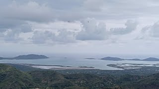
Topography and nature of Île Grosse Caye
Timezone: UTC-05:00
Timezone places: America/New_York
Max. Elevation: 41 m
Mean Elevation: 24 m
Vegetation: Evergreen Needleleaf Forest
Tree Coverage: 91%
The mean elevation is 24 m. The highest elevation on the island reaches approximately 41 meters above sea level. The island is characterized by Plains: Flat, low-lying lands characterized by a maximum elevation of up to 200 meters. On islands, plains are typically coastal lowlands or central flat areas.
Dominating Vegetation: Evergreen Needleleaf Forest
Dominated by evergreen coniferous trees such as pines and firs, which retain their needle-like leaves throughout the year. These forests are often found in cooler climates. Île Grosse Caye has a tree cover of 91 %.
Vegetation: 4 vegetation zones – Diverse Island
Four distinct vegetation zones mark these islands as ecologically diverse. They might feature varied landscapes such as forests, beaches, grasslands, and rocky areas. Such diversity reflects the island’s complex ecological interactions and varied habitats, which can support a rich array of wildlife and plant species.
Infrastructure and Travelling to Île Grosse Caye
Does the island have a public airport? no.
There is no public and scheduled airport on Île Grosse Caye. The nearest airport is Les Cayes Airport, located 41 km away.
Does the island have a major port? no.
There are no major ports on Île Grosse Caye. The closest major port is MIRAGOANE, approximately 42 km away.
The mean population of Île Grosse Caye is 304 per km². Île Grosse Caye is Moderately Inhabited. The island belongs to Haiti.
Continuing your journey, Île à Vache is the next notable island, situated merely km away.
They live in the middle of Ocean: Discover Grosse CAYES ISLAND


Haiti is classified as Least developed region: Countries that exhibit the lowest indicators of socioeconomic development, with the lowest Human Development Index ratings. The level of income is Low income.
News – Latest Updates and Headlines from Île Grosse Caye
Stay informed with the most recent news and important headlines from Île Grosse Caye. Here’s a roundup of the latest developments.
Please note: The data used here has been primarily extracted from satellite readings. Deviations from exact values may occur, particularly regarding the height of elevations and population density. Land area and coastline measurements refer to average values at mean high tide.