Île Poule
Welcome to Île Poule, a Tropical island in the Indian Ocean, part of the majestic Indian Ocean. This guide offers a comprehensive overview of what makes Île Poule unique – from its geography and climate to its population, infrastructure, and beyond. Dive into the details:
- Geography and Size: Explore the island’s size and location.
- Climate and Weather: Weather patterns and temperature.
- Topography and Nature: Uncover the natural wonders of the island.
- Infrastructure and Travelling: Insights on reaching, staying, and making the most of your visit.
- News and Headlines: Latest News.
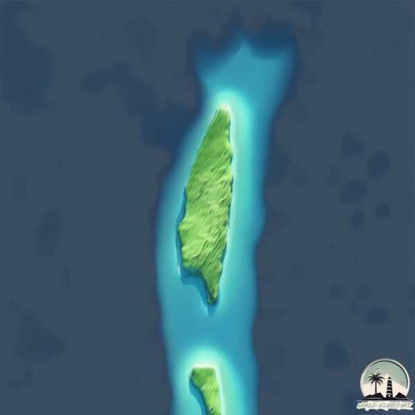
Geography and size of Île Poule
Size: 0.973 km²
Coastline: 5.7 km
Ocean: Indian Ocean
Sea: Indian Ocean
Continent: Seven seas (open ocean)
Île Poule is a Tiny Island spanning 0.973 km² with a coastline of 5.7 km.
Archipel: Chagos Archipelago – A group of atolls in the Indian Ocean, known for the Diego Garcia military base and their rich marine biodiversity.
Tectonic Plate: India – A major tectonic plate that initially moved northward at a rapid pace before colliding with the Eurasian Plate. This collision is responsible for the uplift of the Himalayas and the Tibetan Plateau.
The geographic heart of the island is pinpointed at these coordinates:
Latitude: -5.40555076 / Longitude: 71.75145954
Climate and weather of Île Poule
Climate Zone: Tropical
Climate Details: Tropical Monsoon Climate
Temperature: Hot
Climate Characteristics: Characterized by heavy rainfall, high humidity, and uniformly high temperatures, but with a distinct short dry season. It features a seasonal reversal of prevailing wind directions.
Topography and nature of Île Poule
Timezone: UTC+06:00
Timezone places: Indian/Chagos
Max. Elevation: 5 m
Mean Elevation: 1 m
Vegetation: Open Woodland
Tree Coverage: 72%
The mean elevation is 1 m. The highest elevation on the island reaches approximately 5 meters above sea level. The island is characterized by Plains: Flat, low-lying lands characterized by a maximum elevation of up to 200 meters. On islands, plains are typically coastal lowlands or central flat areas.
Dominating Vegetation: Open Woodland
Characterized by sparsely distributed trees with open canopy allowing sunlight to penetrate, supporting grasses and shrubs underneath. Often found in drier or transitional environments. Île Poule has a tree cover of 72 %.
Vegetation: 4 vegetation zones – Diverse Island
Four distinct vegetation zones mark these islands as ecologically diverse. They might feature varied landscapes such as forests, beaches, grasslands, and rocky areas. Such diversity reflects the island’s complex ecological interactions and varied habitats, which can support a rich array of wildlife and plant species.
Infrastructure and Travelling to Île Poule
Does the island have a public airport? no.
There is no public and scheduled airport on Île Poule. The nearest airport is Gan International Airport, located 545 km away.
Does the island have a major port? no.
There are no major ports on Île Poule. The closest major port is DIEGO GARCIA, approximately 229 km away.
The mean population of Île Poule is per km². Île Poule is . The island belongs to United Kingdom.
Continuing your journey, Sri Lanka is the next notable island, situated merely km away.
Worst chai in the world | Mauritius street food #shorts


United Kingdom is classified as Developed region: G7: Group of Seven – Major advanced economies, including Canada, France, Germany, Italy, Japan, the United Kingdom, and the United States. The level of income is High income: OECD.
News – Latest Updates and Headlines from Île Poule
Stay informed with the most recent news and important headlines from Île Poule. Here’s a roundup of the latest developments.
Please note: The data used here has been primarily extracted from satellite readings. Deviations from exact values may occur, particularly regarding the height of elevations and population density. Land area and coastline measurements refer to average values at mean high tide.