Île Roume
Welcome to Île Roume, a Tropical island in the North Atlantic Ocean, part of the majestic Atlantic Ocean. This guide offers a comprehensive overview of what makes Île Roume unique – from its geography and climate to its population, infrastructure, and beyond. Dive into the details:
- Geography and Size: Explore the island’s size and location.
- Climate and Weather: Weather patterns and temperature.
- Topography and Nature: Uncover the natural wonders of the island.
- Infrastructure and Travelling: Insights on reaching, staying, and making the most of your visit.
- News and Headlines: Latest News.
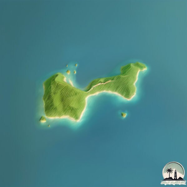
Geography and size of Île Roume
Size: 0.626 km²
Coastline: 5.3 km
Ocean: Atlantic Ocean
Sea: North Atlantic Ocean
Continent: Africa
Île Roume is a Tiny Island spanning 0.626 km² with a coastline of 5.3 km.
Archipel: –
Tectonic Plate: Africa – One of the world’s largest tectonic plates, covering the African continent and parts of the surrounding oceans, known for its stability with some active rift zones.
The geographic heart of the island is pinpointed at these coordinates:
Latitude: 9.46326998 / Longitude: -13.7927959
Climate and weather of Île Roume
Climate Zone: Tropical
Climate Details: Tropical Monsoon Climate
Temperature: Hot
Climate Characteristics: Characterized by heavy rainfall, high humidity, and uniformly high temperatures, but with a distinct short dry season. It features a seasonal reversal of prevailing wind directions.
Topography and nature of Île Roume
Timezone: UTC±00:00
Timezone places: Europe/Lisbon
Max. Elevation: 21 m
Mean Elevation: 15 m
Vegetation: Open Woodland
Tree Coverage: 56%
The mean elevation is 15 m. The highest elevation on the island reaches approximately 21 meters above sea level. The island is characterized by Plains: Flat, low-lying lands characterized by a maximum elevation of up to 200 meters. On islands, plains are typically coastal lowlands or central flat areas.
Dominating Vegetation: Open Woodland
Characterized by sparsely distributed trees with open canopy allowing sunlight to penetrate, supporting grasses and shrubs underneath. Often found in drier or transitional environments. Île Roume has a tree cover of 56 %.
Vegetation: 3 vegetation zones – Moderately Diverse Island
These islands start to show a broader range of ecological niches. With three vegetation zones, they may offer a mix of ecosystems like coastal areas, inland woods, and perhaps a distinct wetland or dry area. This diversity supports a wider range of flora and fauna, making these islands more ecologically complex than those with minimal diversity.
Infrastructure and Travelling to Île Roume
Does the island have a public airport? no.
There is no public and scheduled airport on Île Roume. The nearest airport is Conakry International Airport, located 23 km away.
Does the island have a major port? no.
There are no major ports on Île Roume. The closest major port is CONAKRY, approximately 9 km away.
The mean population of Île Roume is 1526 per km². Île Roume is Densely Populated. The island belongs to Guinea.
Continuing your journey, Île Khonibombé is the next notable island, situated merely km away.
Île de Roume à Conakry - Miranass Tourisme #lœilcurieux #miranasstourisme #guinee #conakry #guinea


Guinea is classified as Least developed region: Countries that exhibit the lowest indicators of socioeconomic development, with the lowest Human Development Index ratings. The level of income is Low income.
News – Latest Updates and Headlines from Île Roume
Stay informed with the most recent news and important headlines from Île Roume. Here’s a roundup of the latest developments.
Please note: The data used here has been primarily extracted from satellite readings. Deviations from exact values may occur, particularly regarding the height of elevations and population density. Land area and coastline measurements refer to average values at mean high tide.