Île Saint-Charles
Welcome to Île Saint-Charles, a Continental island in the Gulf of St. Lawrence, part of the majestic Atlantic Ocean. This guide offers a comprehensive overview of what makes Île Saint-Charles unique – from its geography and climate to its population, infrastructure, and beyond. Dive into the details:
- Geography and Size: Explore the island’s size and location.
- Climate and Weather: Weather patterns and temperature.
- Topography and Nature: Uncover the natural wonders of the island.
- Infrastructure and Travelling: Insights on reaching, staying, and making the most of your visit.
- News and Headlines: Latest News.
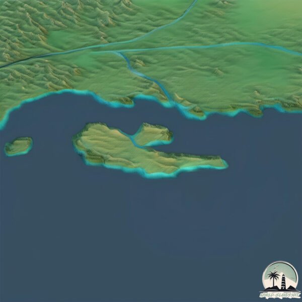
Geography and size of Île Saint-Charles
Size: 7.401 km²
Coastline: 18.9 km
Ocean: Atlantic Ocean
Sea: Gulf of St. Lawrence
Continent: North America
Île Saint-Charles is a Small Island spanning 7.4 km² with a coastline of 18.9 km.
Archipel: –
Tectonic Plate: North America – Covers North America and parts of the Atlantic and Arctic Oceans, characterized by diverse geological features and varying levels of seismic activity.
The geographic heart of the island is pinpointed at these coordinates:
Latitude: 50.20394968 / Longitude: -63.32644832
Climate and weather of Île Saint-Charles
Climate Zone: Continental
Climate Details: Warm-Summer Humid Continental Climate
Temperature: Warm Summer
Climate Characteristics: Features warm summers and cold winters with consistent precipitation, common in higher latitudes.
Topography and nature of Île Saint-Charles
Timezone: UTC-05:00
Timezone places: America/New_York
Max. Elevation: 20 m
Mean Elevation: 7 m
Vegetation: Mixed Forest
Tree Coverage: 93%
The mean elevation is 7 m. The highest elevation on the island reaches approximately 20 meters above sea level. The island is characterized by Plains: Flat, low-lying lands characterized by a maximum elevation of up to 200 meters. On islands, plains are typically coastal lowlands or central flat areas.
Dominating Vegetation: Mixed Forest
A combination of both deciduous and evergreen trees, often found in transitional zones between forest types. These forests offer a diverse habitat for various wildlife species. Île Saint-Charles has a tree cover of 93 %.
Vegetation: 5 vegetation zones – Highly Diverse Island
With five different vegetation zones, these islands offer a rich tapestry of ecosystems. The variety could include dense forests, open meadows, wetlands, coastal zones, and more. This level of diversity supports an intricate web of life, with each zone playing a vital role in the overall ecological health and balance of the island.
Infrastructure and Travelling to Île Saint-Charles
Does the island have a public airport? no.
There is no public and scheduled airport on Île Saint-Charles. The nearest airport is Natashquan Airport, located 166 km away.
Does the island have a major port? no.
There are no major ports on Île Saint-Charles. The closest major port is HAVRE ST PIERRE, approximately 27 km away.
The mean population of Île Saint-Charles is 0 per km². Île Saint-Charles is Uninhabited. The island belongs to Canada.
Continuing your journey, Île à la Chasse is the next notable island, situated merely km away.
Charles Island in Milford is among Connecticut's most haunted destinations


Canada is classified as Developed region: G7: Group of Seven – Major advanced economies, including Canada, France, Germany, Italy, Japan, the United Kingdom, and the United States. The level of income is High income: OECD.
News – Latest Updates and Headlines from Île Saint-Charles
Stay informed with the most recent news and important headlines from Île Saint-Charles. Here’s a roundup of the latest developments.
- Overnight closure planned on Île-aux-Tourtes Bridge toward Montreal - TheSuburban.comby "Île Saint-Charles island" - Google News on 22 March 2026
Overnight closure planned on Île-aux-Tourtes Bridge toward Montreal TheSuburban.com
- Île-aux-Tourtes Bridge eastbound to close Wednesday night - CTV Newsby "Île Saint-Charles island" - Google News on 18 February 2026
Île-aux-Tourtes Bridge eastbound to close Wednesday night CTV News
- Île-aux-Tourtes Bridge closure tonight into Thursday - TheSuburban.comby "Île Saint-Charles island" - Google News on 5 February 2026
Île-aux-Tourtes Bridge closure tonight into Thursday TheSuburban.com
- A cornucopia of weekend detours in store for West Island motorists - TheSuburban.comby "Île Saint-Charles island" - Google News on 16 January 2026
A cornucopia of weekend detours in store for West Island motorists TheSuburban.com
- Ile Aux Tourtes Bridge to close again - TheSuburban.comby "Île Saint-Charles island" - Google News on 26 November 2025
Ile Aux Tourtes Bridge to close again TheSuburban.com
- Île-aux-Tourtes Bridge and La Fontaine Tunnel will close this weekend - CTV Newsby "Île Saint-Charles island" - Google News on 25 November 2025
Île-aux-Tourtes Bridge and La Fontaine Tunnel will close this weekend CTV News
- Update: Île-aux-Tourtes Bridge reopens earlier than expected; La Fontaine Tunnel remains closed - Montreal Gazetteby "Île Saint-Charles island" - Google News on 24 November 2025
Update: Île-aux-Tourtes Bridge reopens earlier than expected; La Fontaine Tunnel remains closed Montreal Gazette
- The what and why of West Island’s traffic havoc - TheSuburban.comby "Île Saint-Charles island" - Google News on 6 November 2025
The what and why of West Island’s traffic havoc TheSuburban.com
- Here are the 2025 mayors for Montreal, surrounding regions and across Quebec - CTV Newsby "Île Saint-Charles island" - Google News on 3 November 2025
Here are the 2025 mayors for Montreal, surrounding regions and across Quebec CTV News
- Greater Montreal mayor and councillor election results - CityNews Montrealby "Île Saint-Charles island" - Google News on 2 November 2025
Greater Montreal mayor and councillor election results CityNews Montreal
Please note: The data used here has been primarily extracted from satellite readings. Deviations from exact values may occur, particularly regarding the height of elevations and population density. Land area and coastline measurements refer to average values at mean high tide.