Welcome to Île Saint-Gildas, a Temperate island in the English Channel, part of the majestic Atlantic Ocean. This guide offers a comprehensive overview of what makes Île Saint-Gildas unique – from its geography and climate to its population, infrastructure, and beyond. Dive into the details:
Geography and size of Île Saint-Gildas
Size: 0.674 km²
Coastline: 4.7 km
Ocean: Atlantic Ocean
Sea: English Channel
Continent: Europe
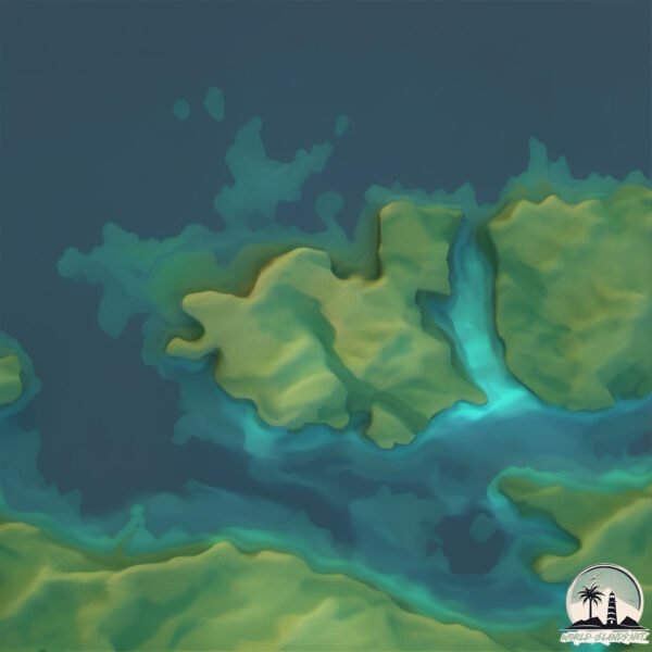
Île Saint-Gildas is a Tiny Island spanning 0.674 km² with a coastline of 4.7 km.
Archipel: –
Tectonic Plate: Eurasia – One of the world’s largest tectonic plates, the Eurasian Plate covers a significant portion of Europe and Asia. It’s characterized by diverse geological features, including the Ural Mountains, the European Plain, and the Himalayas formed from its collision with the Indian Plate.
The geographic heart of the island is pinpointed at these coordinates:
Latitude: 48.84693217 / Longitude: -3.30514033
Climate and weather of Île Saint-Gildas
Climate Zone: Temperate
Climate Details: Temperate Oceanic Climate
Temperature: Warm Summer
Climate Characteristics: Known for its moderate year-round temperatures with ample rainfall and no dry season. Warm summers are characteristic.
Topography and nature of Île Saint-Gildas
Timezone: UTC+01:00
Timezone places: Europe/Paris
Max. Elevation: 2 m
Mean Elevation: -1 m
Vegetation: Evergreen Needleleaf Forest
Tree Coverage: 51%
The mean elevation is -1 m. The highest elevation on the island reaches approximately 2 meters above sea level. The island is characterized by Plains: Flat, low-lying lands characterized by a maximum elevation of up to 200 meters. On islands, plains are typically coastal lowlands or central flat areas.
Dominating Vegetation: Evergreen Needleleaf Forest
Dominated by evergreen coniferous trees such as pines and firs, which retain their needle-like leaves throughout the year. These forests are often found in cooler climates. Île Saint-Gildas has a tree cover of 51 %.
Vegetation: 5 vegetation zones – Highly Diverse Island
With five different vegetation zones, these islands offer a rich tapestry of ecosystems. The variety could include dense forests, open meadows, wetlands, coastal zones, and more. This level of diversity supports an intricate web of life, with each zone playing a vital role in the overall ecological health and balance of the island.
Infrastructure and Travelling to Île Saint-Gildas
Does the island have a public airport? no.
There is no public and scheduled airport on Île Saint-Gildas. The nearest airport is Guernsey Airport, located 101 km away.
Does the island have a major port? no.
There are no major ports on Île Saint-Gildas. The closest major port is TREGUIER, approximately 10 km away.
The mean population of Île Saint-Gildas is 126 per km². Île Saint-Gildas is Moderately Inhabited. The island belongs to France.
Continuing your journey, Guernsey is the next notable island, situated merely km away.
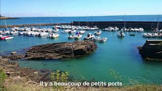
A little bit of Britanny - Île de Houat : Port de Saint Gildas
A little bit of Britanny - Île de Houat : Port de Saint Gildas #shorts #bretagne #belle-île #LePalais #island #île #Houat #SaintGildas ...A little bit of Britanny - Île de Houat : Port de Saint Gildas
A little bit of Britanny - Île de Houat : Port de Saint Gildas #shorts ...
A little bit of Britanny - Île de Houat : Port de Saint Gildas #shorts #bretagne #belle-île #LePalais #island #île #Houat #SaintGildas ...
Presqu'île de Rhuys, Bretagne 🇫🇷 - Avril 2019
Presqu'île de Rhuys - Avril 2019 Video à regarder en HD (1080p) Filmé ...
Presqu'île de Rhuys - Avril 2019 Video à regarder en HD (1080p) Filmé avec une GoPro Hero6 Black #rhuys #bretagne.
Worle and the Island of Steep Holm, as an anchorite !
St. Finnian (d. 550) called “ tutor of the Saints of Ireland,” founder ...
St. Finnian (d. 550) called “ tutor of the Saints of Ireland,” founder of Clonard at the head waters of the river Boyne, studied for thirty ...
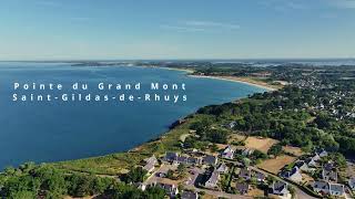
Detour par la Pointe du Grand Mont - Saint Gildas de Rhuys (Lokentaz), Morbihan, Bretagne, Breizh
Découvrez la Pointe du Grand Mont à Saint-Gildas-de-Rhuys en Bretagne, ...
Découvrez la Pointe du Grand Mont à Saint-Gildas-de-Rhuys en Bretagne, filmée par drone. Une vue aérienne unique sur le ...
Port Saint Gildas sur l'Ile de Houat, Morbihan en Bretagne - Série Ports et Escales
Découvrir Port Saint Gildas sur l'Ile de Houat vu du ciel, le port, ...
Découvrir Port Saint Gildas sur l'Ile de Houat vu du ciel, le port, les mouillages et les belles navigations à la voile le long des côtes ...
Pointe du Grand Mont - Saint-Gildas-de-Rhuys, Morbihan, Bretagne | DRONE 4k #1
Série de vidéos 4k en drone pour présenter les plus beaux endroits de ...
Série de vidéos 4k en drone pour présenter les plus beaux endroits de la planète. Face à l'océan, on rencontre une côte ...
SAINT-GILDAS-DE-RHUYS | En mode Hiver | Bretagne Télé
Saint-Gildas-de-Rhuys en Bretagne se repose à un mois des fêtes de fin ...
Saint-Gildas-de-Rhuys en Bretagne se repose à un mois des fêtes de fin d'année. Une marée rouge vient taquiner la plage de ...
ÎLE DE HOUAT 🇲🇫 | Les Plages Paradisiaques | TV Quiberon 24/7
Île de Houat / Bretagne. Houat, le Paradis. C'est l'été sur l'Ile de ...
Île de Houat / Bretagne. Houat, le Paradis. C'est l'été sur l'Ile de Houat à quelques encablures de la presqu'ile de Quiberon dans ...
Hiking - Coast trail of Saint-Gildas De Rhuys, Brittany France.
42:00 Special talk about our french trip. Facing the ocean, one ...
42:00 Special talk about our french trip. Facing the ocean, one encounters rocky coves cut (from the beach to the tip of goblins ...
Houat quelle belle ile
Compilation de photos de l'île de houat, Plus de photos sur le ...
Compilation de photos de l'île de houat, Plus de photos sur le facebook de Marc Duval.
HOUAT LE PORT SAINT-GILDAS Cartes Postales anciennes
Île de Houat - Cartes postales anciennes - ...
Plage des Govelins à Saint Gildas de Rhuys #saintgildasderhuys #vue panoramique #magnifique #bzh
Bretagne Morbihan (56) - Presqu'île de Rhuys: Arzon - St Gildas - Sarzeau - Tour du parc - St Armel
La Communauté de communes de la presqu'île de Rhuys a été créée le 15 ...
La Communauté de communes de la presqu'île de Rhuys a été créée le 15 décembre 2005. Elle regroupe cinq communes ...
Promotion Touristique - Saint Gildas de Rhuys
Vue touristique de la Presqu'île de Rhuys.
Vue touristique de la Presqu'île de Rhuys.
La Bretagne - St Gildas de Rhuys.
Discover with your child a village in South Brittany (France).
Discover with your child a village in South Brittany (France).
Île de Houat - Région Bretagne - Stéphane Bern - Le Village Préféré des Français - MG
À quelques encablures de la baie de Quiberon, l'île d'Houat séduit ...
À quelques encablures de la baie de Quiberon, l'île d'Houat séduit tous les amoureux de la mer et de la nature. Pour découvrir ...
Série France Télévision - Plages secrètes - Saint-Gildas-de-Rhuys
Reportage : J.Desrousseaux, P. Maire, B. De Saint Jore. Images drone : ...
Reportage : J.Desrousseaux, P. Maire, B. De Saint Jore. Images drone : Glaz Media.
ÎLE DE HOUAT 🇲🇫 | Une ile de Bretagne en Hiver | ÎIe de Houat TV
L'Ile de Houat au large de Quiberon en Bretagne dans le Morbihan est ...
L'Ile de Houat au large de Quiberon en Bretagne dans le Morbihan est très calme, reposante au début de l'année. La végétation ...
Cinematic beach film (Saint-Gildas, Golfe du Morbihan)
Souvenir d'un bel été. The Realization - Ryan Taubert Seaside - Haux.
Souvenir d'un bel été. The Realization - Ryan Taubert Seaside - Haux.
Gildas and the Islands of the Blest told by David Metcalfe of Fire Springs
Discover the tale of St Brendan as told by the 6th century monk and ...
Discover the tale of St Brendan as told by the 6th century monk and historian, Gildas, told by David Metcalfe of Fire Springs.
Village de l'Île d'Houat - Morbihan
BRETAGNE | île-d'Houat die Traumstrandinsel | SBF Schweiz Bretagne Fernsehen 🇨🇭
île-d'Houat / Frankreich. Gelegen zwischen der Südspitze der Halbinsel ...
île-d'Houat / Frankreich. Gelegen zwischen der Südspitze der Halbinsel Quiberon, dem Festland und der Belle-Île-en-Mer gehört ...
Presqu'île de Rhuys - Le Grand Mont et Le Pen Castel - Air Drone Vision
Presqu'île de Rhuys - Le Grand Mont de St Gildas de Rhuys et Le Pen ...
Presqu'île de Rhuys - Le Grand Mont de St Gildas de Rhuys et Le Pen Castel d'Arzon - (56) Morbihan - Août 2016 par Air Drone ...
ÎLE DE HOUAT 🇲🇫 | Dormir en mer dans un vrai Fort | Île de Houat TV
Houat et son Fort. Dormair sur l'Ile de Houat dans un lieu incroyable, ...
Houat et son Fort. Dormair sur l'Ile de Houat dans un lieu incroyable, comme un seigneur, sejourner dans un véritable Fort en ...
A little bit of Britanny - Petit matin : bateau de pêche au ponton
A little bit of Britanny - Petit matin : bateau de pêche au ponton ...
A little bit of Britanny - Petit matin : bateau de pêche au ponton #shorts #bretagne #belle-île #LePalais #island #île #Houat ...
France is classified as Developed region: G7: Group of Seven – Major advanced economies, including Canada, France, Germany, Italy, Japan, the United Kingdom, and the United States. The level of income is High income: OECD.
News – Latest Updates and Headlines from Île Saint-Gildas
Stay informed with the most recent news and important headlines from Île Saint-Gildas. Here’s a roundup of the latest developments.
Loading...
Please note: The data used here has been primarily extracted from satellite readings. Deviations from exact values may occur, particularly regarding the height of elevations and population density. Land area and coastline measurements refer to average values at mean high tide.