Ilha de Itamaracá
Welcome to Ilha de Itamaracá, a Tropical island in the South Atlantic Ocean, part of the majestic Atlantic Ocean. This guide offers a comprehensive overview of what makes Ilha de Itamaracá unique – from its geography and climate to its population, infrastructure, and beyond. Dive into the details:
- Geography and Size: Explore the island’s size and location.
- Climate and Weather: Weather patterns and temperature.
- Topography and Nature: Uncover the natural wonders of the island.
- Infrastructure and Travelling: Insights on reaching, staying, and making the most of your visit.
- News and Headlines: Latest News.
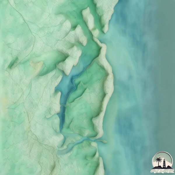
Geography and size of Ilha de Itamaracá
Size: 59.9 km²
Coastline: 48.1 km
Ocean: Atlantic Ocean
Sea: South Atlantic Ocean
Continent: South America
Ilha de Itamaracá is a Medium Island spanning 60 km² with a coastline of 48 km.
Archipel: –
Tectonic Plate: South America – A major plate covering the South American continent and part of the Atlantic Ocean, known for the Andes mountain range and significant seismic and volcanic activity.
The geographic heart of the island is pinpointed at these coordinates:
Latitude: -7.75885125 / Longitude: -34.85276499
Climate and weather of Ilha de Itamaracá
Climate Zone: Tropical
Climate Details: Tropical Savanna, Wet
Temperature: Hot
Climate Characteristics: Defined by distinct wet and dry seasons with high temperatures year-round. Pronounced rainfall occurs during the wet season, while the dry season is marked by drought.
Topography and nature of Ilha de Itamaracá
Timezone: UTC-03:00
Timezone places: America/Sao_Paulo
Max. Elevation: 63 m
Mean Elevation: 23 m
Vegetation: Evergreen Broadleaf Forest
Tree Coverage: 42%
The mean elevation is 23 m. The highest elevation on the island reaches approximately 63 meters above sea level. The island is characterized by Plains: Flat, low-lying lands characterized by a maximum elevation of up to 200 meters. On islands, plains are typically coastal lowlands or central flat areas.
Dominating Vegetation: Evergreen Broadleaf Forest
Characterized by dense, lush canopies of broadleaf trees that retain their leaves year-round. These forests are typically found in tropical and subtropical regions and are known for their high biodiversity. Ilha de Itamaracá has a tree cover of 42 %.
Vegetation: 11 vegetation zones – Exceptionally Diverse Island
Islands with more than ten vegetation zones are among the most ecologically rich and varied in the world. These islands are akin to miniature continents, boasting an incredible array of ecosystems. The sheer range of habitats, from high peaks to deep valleys, rainforests to deserts, creates a mosaic of life that is unparalleled. They are crucial for conservation and ecological studies.
Infrastructure and Travelling to Ilha de Itamaracá
Does the island have a public airport? no.
There is no public and scheduled airport on Ilha de Itamaracá. The nearest airport is Recife/Guararapes – Gilberto Freyre International Airport, located 36 km away.
Does the island have a major port? no.
There are no major ports on Ilha de Itamaracá. The closest major port is RECIFE, approximately 26 km away.
The mean population of Ilha de Itamaracá is 505 per km². Ilha de Itamaracá is Densely Populated. The island belongs to Brazil.
Continuing your journey, Ilha Santa Rita is the next notable island, situated merely km away.
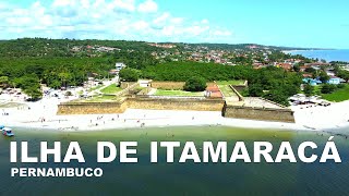
ILHA DE ITAMARACÁ | PERNAMBUCO | JANEIRO DE 2022


Brazil is classified as Emerging region: BRIC: Brazil, Russia, India, and China – Economies noted for their rapid growth and increasing influence on global affairs. The level of income is Upper middle income.
News – Latest Updates and Headlines from Ilha de Itamaracá
Stay informed with the most recent news and important headlines from Ilha de Itamaracá. Here’s a roundup of the latest developments.
Please note: The data used here has been primarily extracted from satellite readings. Deviations from exact values may occur, particularly regarding the height of elevations and population density. Land area and coastline measurements refer to average values at mean high tide.