Ilha do Tamanduá
Welcome to Ilha do Tamanduá, a Tropical island in the South Atlantic Ocean, part of the majestic Atlantic Ocean. This guide offers a comprehensive overview of what makes Ilha do Tamanduá unique – from its geography and climate to its population, infrastructure, and beyond. Dive into the details:
- Geography and Size: Explore the island’s size and location.
- Climate and Weather: Weather patterns and temperature.
- Topography and Nature: Uncover the natural wonders of the island.
- Infrastructure and Travelling: Insights on reaching, staying, and making the most of your visit.
- News and Headlines: Latest News.
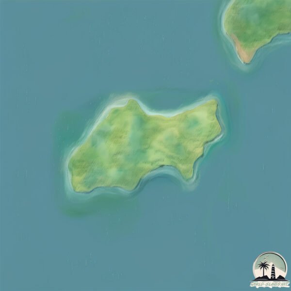
Geography and size of Ilha do Tamanduá
Size: 1.049 km²
Coastline: 4.8 km
Ocean: Atlantic Ocean
Sea: South Atlantic Ocean
Continent: South America
Ilha do Tamanduá is a Small Island spanning 1 km² with a coastline of 4.8 km.
Archipel: –
Tectonic Plate: Pacific – The world’s largest tectonic plate, covering much of the Pacific Ocean, known for the Pacific Ring of Fire with extensive seismic and volcanic activity.
The geographic heart of the island is pinpointed at these coordinates:
Latitude: -23.59738718 / Longitude: -45.28823671
Climate and weather of Ilha do Tamanduá
Climate Zone: Tropical
Climate Details: Tropical Rainforest Climate
Temperature: Hot
Climate Characteristics: This climate is typified by heavy rainfall throughout the year, high humidity, and consistently high temperatures, leading to lush rainforests and rich biodiversity. Seasonal temperature variations are minimal.
Topography and nature of Ilha do Tamanduá
Timezone: UTC-03:00
Timezone places: America/Sao_Paulo
Max. Elevation: 57 m
Mean Elevation: 34 m
Vegetation: Evergreen Broadleaf Forest
Tree Coverage: 97%
The mean elevation is 34 m. The highest elevation on the island reaches approximately 57 meters above sea level. The island is characterized by Plains: Flat, low-lying lands characterized by a maximum elevation of up to 200 meters. On islands, plains are typically coastal lowlands or central flat areas.
Dominating Vegetation: Evergreen Broadleaf Forest
Characterized by dense, lush canopies of broadleaf trees that retain their leaves year-round. These forests are typically found in tropical and subtropical regions and are known for their high biodiversity. Ilha do Tamanduá has a tree cover of 97 %.
Vegetation: 2 vegetation zones – Low Diversity Island
Islands with two distinct vegetation zones offer slightly more ecological variety. These zones could be due to differences in elevation, moisture, or other environmental factors. While still limited in biodiversity, these islands may offer a contrast between the two zones, such as a coastline with mangroves and an inland area with grassland.
Infrastructure and Travelling to Ilha do Tamanduá
Does the island have a public airport? no.
There is no public and scheduled airport on Ilha do Tamanduá. The nearest airport is Paraty Airport, located 74 km away.
Does the island have a major port? no.
There are no major ports on Ilha do Tamanduá. The closest major port is SAO SEBASTIAO, approximately 25 km away.
The mean population of Ilha do Tamanduá is 0 per km². Ilha do Tamanduá is Uninhabited. The island belongs to Brazil.
Continuing your journey, Ilha de São Sebastião is the next notable island, situated merely km away.
ILHA DO TAMANDUÁ - LITORAL NORTE SP - VIAJANDO COM HUGO COUTO


Brazil is classified as Emerging region: BRIC: Brazil, Russia, India, and China – Economies noted for their rapid growth and increasing influence on global affairs. The level of income is Upper middle income.
News – Latest Updates and Headlines from Ilha do Tamanduá
Stay informed with the most recent news and important headlines from Ilha do Tamanduá. Here’s a roundup of the latest developments.
Please note: The data used here has been primarily extracted from satellite readings. Deviations from exact values may occur, particularly regarding the height of elevations and population density. Land area and coastline measurements refer to average values at mean high tide.