Welcome to Ilha dos Ratos, a Temperate island in the South Atlantic Ocean, part of the majestic Atlantic Ocean. This guide offers a comprehensive overview of what makes Ilha dos Ratos unique – from its geography and climate to its population, infrastructure, and beyond. Dive into the details:
Geography and size of Ilha dos Ratos
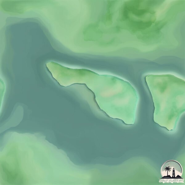
Size: 0.228 km²
Coastline: 2.6 km
Ocean: Atlantic Ocean
Sea: South Atlantic Ocean
Continent: South America
Ilha dos Ratos is a Tiny Island spanning 0.228 km² with a coastline of 2.6 km.
Archipel: –
Tectonic Plate: South America – A major plate covering the South American continent and part of the Atlantic Ocean, known for the Andes mountain range and significant seismic and volcanic activity.
The geographic heart of the island is pinpointed at these coordinates:
Latitude: -25.49458134 / Longitude: -48.70353866
Climate and weather of Ilha dos Ratos
Climate Zone: Temperate
Climate Details: Humid Subtropical Climate
Temperature: Hot Summer
Climate Characteristics: With continuous rainfall and hot summers, this climate is common in some coastal regions, supporting diverse vegetation.
Topography and nature of Ilha dos Ratos
Timezone: UTC-03:00
Timezone places: America/Sao_Paulo
Max. Elevation: 4 m
Mean Elevation: 1 m
Vegetation: Open Woodland
Tree Coverage: 38%
The mean elevation is 1 m. The highest elevation on the island reaches approximately 4 meters above sea level. The island is characterized by Plains: Flat, low-lying lands characterized by a maximum elevation of up to 200 meters. On islands, plains are typically coastal lowlands or central flat areas.
Dominating Vegetation: Open Woodland
Characterized by sparsely distributed trees with open canopy allowing sunlight to penetrate, supporting grasses and shrubs underneath. Often found in drier or transitional environments. Ilha dos Ratos has a tree cover of 38 %.
Vegetation: 2 vegetation zones – Low Diversity Island
Islands with two distinct vegetation zones offer slightly more ecological variety. These zones could be due to differences in elevation, moisture, or other environmental factors. While still limited in biodiversity, these islands may offer a contrast between the two zones, such as a coastline with mangroves and an inland area with grassland.
Infrastructure and Travelling to Ilha dos Ratos
Does the island have a public airport? no.
There is no public and scheduled airport on Ilha dos Ratos. The nearest airport is Afonso Pena Airport, located 52 km away.
Does the island have a major port? no.
There are no major ports on Ilha dos Ratos. The closest major port is PARANAGUA, approximately 20 km away.
The mean population of Ilha dos Ratos is 14 per km². Ilha dos Ratos is Gently Populated. The island belongs to Brazil.
Continuing your journey, Ilha do Mel is the next notable island, situated merely km away.
Eles Soltaram Milhares De Ratos Em Uma Ilha Cheia De Pinguins —E O Que Aconteceu Depois Foi Horrível
Eles Soltaram Milhares De Ratos Em Uma Ilha Cheia De Pinguins —E O Que Aconteceu Depois Foi Horrível Macquarie já foi um ...Eles Soltaram Milhares De Ratos Em Uma Ilha Cheia De Pinguins —E O Que Aconteceu Depois Foi Horrível
Eles Soltaram Milhares De Ratos Em Uma Ilha Cheia De Pinguins —E O Que ...
Eles Soltaram Milhares De Ratos Em Uma Ilha Cheia De Pinguins —E O Que Aconteceu Depois Foi Horrível Macquarie já foi um ...
A Nova Zelândia ELIMINOU TODOS OS RATOS DA ILHA — As CONSEQUÊNCIAS VÃO TE CHOCAR
A Nova Zelândia ELIMINOU TODOS OS RATOS DA ILHA — As CONSEQUÊNCIAS VÃO ...
A Nova Zelândia ELIMINOU TODOS OS RATOS DA ILHA — As CONSEQUÊNCIAS VÃO TE CHOCAR A vida em ilhas remotas ...
Eles Deixaram MILHARES DE RATOS E PINGUINS EM UMA PEQUENA ILHA – Anos Depois A ILHA DESAPARECEU
Eles Deixaram MILHARES DE RATOS E PINGUINS EM UMA PEQUENA ILHA – Anos ...
Eles Deixaram MILHARES DE RATOS E PINGUINS EM UMA PEQUENA ILHA – Anos Depois A ILHA DESAPARECEU Nas ...
Eles erradicaram todos os ratos da ilha... Um ano depois, todos ficaram chocados
Uma das operações de conservação mais ousadas já realizadas: erradicar ...
Uma das operações de conservação mais ousadas já realizadas: erradicar totalmente uma praga de camundongos predadores ...
PORQUE A ILHA DAS COBRAS É UMA FARSA #richardrasmussen #juliobalestrin #ilhadascobras
MERGULHO em Paraty | Ilha dos Ratos | Sailing MotionMe Ep. 10
Quanto mais tempo no mar, maior nossa conexão com ele… descobrir ...
Quanto mais tempo no mar, maior nossa conexão com ele… descobrir Paraty subaquática foi mágico e todo o mistério da vida ...
Porque os animais e plantas da ilhas Galápagos são tão diferentes? #mapas #geografia #galápagos
Ilha dos Ratos | Paraty - RJ | Paraíso
A Ilha dos Ratos é uma pequena ilha localizada no município de Paraty, ...
A Ilha dos Ratos é uma pequena ilha localizada no município de Paraty, no estado do Rio de Janeiro. É uma ilha rochosa com ...
ELIMINARAM TODOS OS RATOS DA ILHA… UM ANO DEPOIS, O QUE ACONTECEU CHOCOU
ELIMINARAM TODOS OS RATOS DA ILHA… UM ANO DEPOIS, O QUE ACONTECEU CHOCOU ...
ELIMINARAM TODOS OS RATOS DA ILHA… UM ANO DEPOIS, O QUE ACONTECEU CHOCOU ...
Eles Jogaram Milhares de Ratos em uma Ilha de Pinguins – E Isso Mudou Tudo
Milhares de ratos foram soltos em uma ilha remota habitada por ...
Milhares de ratos foram soltos em uma ilha remota habitada por pinguins — e o que aconteceu depois vai te surpreender.
Como se livrar de ratos em uma ilha? #disciplina #motivation #davidgoggins
OS BIZARROS ANIMAIS DA ILHA DE GALÁPAGOS #richardrasmussen #biologohenrique #animais #galápagos
Siargao Island Has RATS, DON’T COME 🇵🇭
siargao #siargaoisland #siargaovlog #philippines #islandlife.
siargao #siargaoisland #siargaovlog #philippines #islandlife.
Música - A Canção Dos Ratos - Barbie em a Princesa da Ilha (PT-BR HD)
GOSTARIA DE AGRADECER AOS INSCRITOS t0xIc. .x, Itaywanne Sales e ...
GOSTARIA DE AGRADECER AOS INSCRITOS t0xIc. .x, Itaywanne Sales e Juliana Melo POR AJUDAREM COM A LETRA DA ...
Milhares de ratos foram deixados sozinhos com pinguins em uma ilha, e os resultados chocaram a todos
A INCRÍVEL RECUPERAÇÃO DA ILHA MACQUARIE | De desastre ambiental a ...
A INCRÍVEL RECUPERAÇÃO DA ILHA MACQUARIE | De desastre ambiental a exemplo mundial Menos de duas décadas após ...
Mergulho Ilha dos Ratos - Paraty
Águas claras e temperatura 32ºC Dia de Caribe Janeiro 2019 Mergulhos ...
Águas claras e temperatura 32ºC Dia de Caribe Janeiro 2019 Mergulhos com PADivers e Dive Paraty.
Esse lugar te paralisaria de medo: ILHA DAS BONECAS - MÉXICO #dark
Eai? Você teria coragem de visitar essa ilha no México?
Eai? Você teria coragem de visitar essa ilha no México?
Ilha fiscal originalmente denominada pelos portugueses como Ilha dos Ratos,
A Ilha Fiscal localiza-se no interior da baía de Guanabara, fronteira ...
A Ilha Fiscal localiza-se no interior da baía de Guanabara, fronteira ao centro histórico da cidade do Rio de Janeiro, no Brasil.
Native Island Rat Control with Goodnature A24 (Full Length)
Native Island has the distinction of being the first island to have ...
Native Island has the distinction of being the first island to have had rats removed by Goodnature self-resetting multi-kill traps.
Pesca Submarina na Ilha do Xavier - Florianópolis
Neste vídeo, embarcamos em uma aventura de pesca submarina na ...
Neste vídeo, embarcamos em uma aventura de pesca submarina na paradisíaca Ilha do Xavier, em Florianópolis. Com águas ...
Como a Geórgia do Sul ficou livre de ratos?
Já ouviu falar sobre a Geórgia do Sul? Remota, a ilha na região ...
Já ouviu falar sobre a Geórgia do Sul? Remota, a ilha na região Sub-Antártica é o local onde o grande explorador Sir Ernest ...
Rats are Taking Over Islands 🐀 📈 #learn #learnonyoutube #animation #animals
Rats and mice rank among the most destructive invasive species on ...
Rats and mice rank among the most destructive invasive species on Earth. To grasp the scale of their ecological impact, just look ...
42km na Ilha Ninho dos Ratos, Rottnest Island 🏃🏻♂️👟🪽🐀🦘🇧🇷🇦🇺 #run #marathon #nikerunning #corredores
Maratona na Ilha de Rottnest- Australia, por enquanto a maratona mais ...
Maratona na Ilha de Rottnest- Australia, por enquanto a maratona mais dificil que fiz, o percurso com muitas subdas e descidas, ...
Eles Deixaram Milhares de Ratos Sozinhos com Pinguins em uma Pequena Ilha
Descubra a fascinante e trágica história de uma ilha isolada que ...
Descubra a fascinante e trágica história de uma ilha isolada que enfrentou um colapso ecológico devastador. Neste vídeo ...
Brazil is classified as Emerging region: BRIC: Brazil, Russia, India, and China – Economies noted for their rapid growth and increasing influence on global affairs. The level of income is Upper middle income.
News – Latest Updates and Headlines from Ilha dos Ratos
Stay informed with the most recent news and important headlines from Ilha dos Ratos. Here’s a roundup of the latest developments.
Loading...
Please note: The data used here has been primarily extracted from satellite readings. Deviations from exact values may occur, particularly regarding the height of elevations and population density. Land area and coastline measurements refer to average values at mean high tide.