Welcome to Ilha Pendi, a Tropical island in the South Atlantic Ocean, part of the majestic Atlantic Ocean. This guide offers a comprehensive overview of what makes Ilha Pendi unique – from its geography and climate to its population, infrastructure, and beyond. Dive into the details:
Geography and size of Ilha Pendi
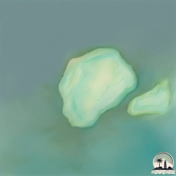
Size: 1.91 km²
Coastline: 6 km
Ocean: Atlantic Ocean
Sea: South Atlantic Ocean
Continent: Africa
Ilha Pendi is a Small Island spanning 1.9 km² with a coastline of 6 km.
Archipel: –
Tectonic Plate: Banda Sea – A small plate in the eastern Indonesian region, known for complex interactions with the Australian and Pacific plates, leading to notable seismic and volcanic activity.
The geographic heart of the island is pinpointed at these coordinates:
Latitude: -6.06101878 / Longitude: 12.58255518
Climate and weather of Ilha Pendi
Climate Zone: Tropical
Climate Details: Tropical Savanna, Wet
Temperature: Hot
Climate Characteristics: Defined by distinct wet and dry seasons with high temperatures year-round. Pronounced rainfall occurs during the wet season, while the dry season is marked by drought.
Topography and nature of Ilha Pendi
Timezone: UTC+01:00
Timezone places: Europe/Paris
Max. Elevation: 12 m
Mean Elevation: 11 m
Vegetation: Mangrove Forest
Tree Coverage: 61%
The mean elevation is 11 m. The highest elevation on the island reaches approximately 12 meters above sea level. The island is characterized by Plains: Flat, low-lying lands characterized by a maximum elevation of up to 200 meters. On islands, plains are typically coastal lowlands or central flat areas.
Dominating Vegetation: Mangrove Forest
Found in coastal areas and river deltas, these unique wetland ecosystems are adapted to saline conditions and are crucial for coastal protection and biodiversity. Ilha Pendi has a tree cover of 61 %.
Vegetation: 3 vegetation zones – Moderately Diverse Island
These islands start to show a broader range of ecological niches. With three vegetation zones, they may offer a mix of ecosystems like coastal areas, inland woods, and perhaps a distinct wetland or dry area. This diversity supports a wider range of flora and fauna, making these islands more ecologically complex than those with minimal diversity.
Infrastructure and Travelling to Ilha Pendi
Does the island have a public airport? no.
There is no public and scheduled airport on Ilha Pendi. The nearest airport is Soyo Airport, located 24 km away.
Does the island have a major port? no.
There are no major ports on Ilha Pendi. The closest major port is BANANA, approximately 23 km away.
The mean population of Ilha Pendi is 66 per km². Ilha Pendi is Gently Populated. The island belongs to Angola.
Continuing your journey, Ilha da Quissanga is the next notable island, situated merely km away.
Nusa Penida, Indonesia | #indonesia #nusapenida #travel
Welcome to Nusa Penida, where adventure meets paradise! ✨ Whether you're relaxing on the stunning Kelingking Beach (yes, ...Nusa Penida, Indonesia | #indonesia #nusapenida #travel
Welcome to Nusa Penida, where adventure meets paradise! ✨ Whether ...
Welcome to Nusa Penida, where adventure meets paradise! ✨ Whether you're relaxing on the stunning Kelingking Beach (yes, ...
Explore Nusa Penida in 1 Day | All Inclusive Private Island Tour with Best Bali Adventures
Escape Bali's mainland and discover paradise on the Nusa Penida 1 Day ...
Escape Bali's mainland and discover paradise on the Nusa Penida 1 Day Island Trip by Best Bali Adventures Visit Kelingking ...
🌏Nusa Penida, Bali
Your journey begins the moment you book. Use code YTB25 for 10% off ...
Your journey begins the moment you book. Use code YTB25 for 10% off European trains + 5% off UK trains. #trainpal #travel ...
Most beautiful beach in Nusa Penida - Kelingking Beach 🏝️
Watch my full Nusa Penida vlog here: ...
Places to visit in East Nusa Penida Bali #travel #nusapenida #bali #island #internationaltravel
300ft Cliff Jump In Nusa Penida
We took a quick boat ride over to Nusa Penida hopped on our scooters ...
We took a quick boat ride over to Nusa Penida hopped on our scooters and drove across the island. We arrived at Kelingking ...
Kelingking Beach -Instagram VS Reality. #bali #kelingkingbeach #balitravel #sunset #baliadventure
The truth behind Kelingking Beach.
The truth behind Kelingking Beach.
Nusa Penida Most Beautiful Places - 4k - Bali Drone Production
Discover the most beautiful and tourist places in Nusa Penida. The ...
Discover the most beautiful and tourist places in Nusa Penida. The island is close to Bali and accessible by fast boat in only 45min ...
BEST Things To Do in Nusa Penida Bali 🇮🇩 Ultimate Travel Guide
Everything you need to know before traveling to Nusa Penida Bali. We ...
Everything you need to know before traveling to Nusa Penida Bali. We include the best things to do, how to get there, 3-day ...
The hike up and down from Kelingking Beach, Nusa Penida, Bali
Kelingking Beach, Nusa Penida (T-Rex Beach):
Nusa Penida Island Tour Bali | Complete Day Trip Guide + Costs (2025) Resty kamboj || Neha Bagga
Nusa Penida is one of the most beautiful and trending islands in Bali, ...
Nusa Penida is one of the most beautiful and trending islands in Bali, famous for its dramatic cliffs, turquoise blue waters, and ...
NUSA PENIDA TRAVEL GUIDE 2025 | Best things to do
Bali’s Hidden Gem! 🌴 Top 6 Places to See in Nusa Penida!
6 reasons why Nusa Penida should be on your Bali bucket list! ✨ From ...
6 reasons why Nusa Penida should be on your Bali bucket list! ✨ From jaw-dropping cliffs to crystal-clear waters, this island is a ...
✈️ BUCKETLIST: Nusa Lembongan! #indonesia #lembongan #bali #nusalembongan #YelloBridgeLembongan
Looking for a tropical vacation? Look no further than Nusa Lembongan! ...
Looking for a tropical vacation? Look no further than Nusa Lembongan! The idyllic island is known for its crystal-clear beaches, ...
REALITY OF BALI (NUSA PENIDA)🥲 Bali Guide 2025✨ Don’t go w/o watching THIS #travel #bali #shorts
BALI’s most POPULAR beach 🥹😍 Kelingking Beach Nusa Penida #nusapenida #bali #travel
One Day Trip to Nusa Penida | Most Beautiful Island in Bali #travel #bali #indonesia #shorts
One Day Trip to Nusa Penida.
One Day Trip to Nusa Penida.
NUSA PENIDA travel guide | EVERYTHING to know before you go😁🌴
We cover everything you NEED to know before traveling to the island of ...
We cover everything you NEED to know before traveling to the island of Penida Best AIRBNB Nusa Penida video ...
Nusa Penida: Day Trip From Bali With GetYourGuide
Join me on my day trip adventure from Bali to Nusa Penida with ...
Join me on my day trip adventure from Bali to Nusa Penida with GetYourGuide! This experience covers 5 highlights across East ...
Nusa Penida Island - Paradise Beaches of Bali, Indonesia
Nusa Penida is an island southeast of Bali in Indonesia. The video ...
Nusa Penida is an island southeast of Bali in Indonesia. The video will show the paradise-like beaches along Nusa Penida's ...
Things to do in nusa penida
Your Bali adventure isn't complete without exploring Nusa Penida. From ...
Your Bali adventure isn't complete without exploring Nusa Penida. From snorkeling with manta rays to hiking to hidden waterfalls, ...
How to reach Nusa Penida from Bali #shorts
Ferry departs from: Ferry departs from Bali to Nusa Penida, from the ...
Ferry departs from: Ferry departs from Bali to Nusa Penida, from the following locations. Sanur is the most convenient port of ...
IT CAN BE DANGEROUS TO SWIM HERE - Angel's Billabong #nusapenida #balitravel #shorts #travel
Islam Makhachev vs Ilia Topuria | Who do you pick✅‼️ #ufc #mma
Angola is classified as Least developed region: Countries that exhibit the lowest indicators of socioeconomic development, with the lowest Human Development Index ratings. The level of income is Upper middle income.
News – Latest Updates and Headlines from Ilha Pendi
Stay informed with the most recent news and important headlines from Ilha Pendi. Here’s a roundup of the latest developments.
Loading...
Please note: The data used here has been primarily extracted from satellite readings. Deviations from exact values may occur, particularly regarding the height of elevations and population density. Land area and coastline measurements refer to average values at mean high tide.