Ilha São Rica
Welcome to Ilha São Rica, a Tropical island in the South Atlantic Ocean, part of the majestic Atlantic Ocean. This guide offers a comprehensive overview of what makes Ilha São Rica unique – from its geography and climate to its population, infrastructure, and beyond. Dive into the details:
- Geography and Size: Explore the island’s size and location.
- Climate and Weather: Weather patterns and temperature.
- Topography and Nature: Uncover the natural wonders of the island.
- Infrastructure and Travelling: Insights on reaching, staying, and making the most of your visit.
- News and Headlines: Latest News.
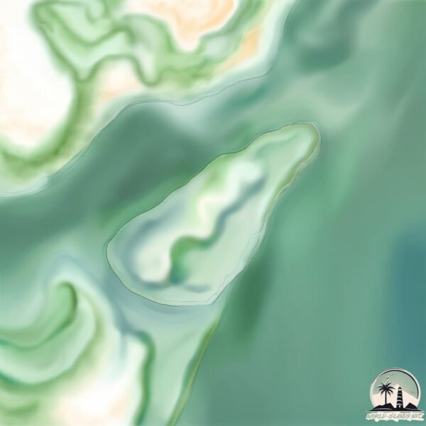
Geography and size of Ilha São Rica
Size: 0.148 km²
Coastline: 1.7 km
Ocean: Atlantic Ocean
Sea: South Atlantic Ocean
Continent: South America
Ilha São Rica is a Tiny Island spanning 0.148 km² with a coastline of 1.7 km.
Archipel: –
Tectonic Plate: South America – A major plate covering the South American continent and part of the Atlantic Ocean, known for the Andes mountain range and significant seismic and volcanic activity.
The geographic heart of the island is pinpointed at these coordinates:
Latitude: -9.73180937 / Longitude: -35.81617432
Climate and weather of Ilha São Rica
Climate Zone: Tropical
Climate Details: Tropical Savanna, Wet
Temperature: Hot
Climate Characteristics: Defined by distinct wet and dry seasons with high temperatures year-round. Pronounced rainfall occurs during the wet season, while the dry season is marked by drought.
Topography and nature of Ilha São Rica
Timezone: UTC-03:00
Timezone places: America/Sao_Paulo
Max. Elevation: 5 m
Mean Elevation: 2 m
Vegetation: Evergreen Broadleaf Forest
Tree Coverage: 12%
The mean elevation is 2 m. The highest elevation on the island reaches approximately 5 meters above sea level. The island is characterized by Plains: Flat, low-lying lands characterized by a maximum elevation of up to 200 meters. On islands, plains are typically coastal lowlands or central flat areas.
Dominating Vegetation: Evergreen Broadleaf Forest
Characterized by dense, lush canopies of broadleaf trees that retain their leaves year-round. These forests are typically found in tropical and subtropical regions and are known for their high biodiversity. Ilha São Rica has a tree cover of 12 %.
Vegetation: 4 vegetation zones – Diverse Island
Four distinct vegetation zones mark these islands as ecologically diverse. They might feature varied landscapes such as forests, beaches, grasslands, and rocky areas. Such diversity reflects the island’s complex ecological interactions and varied habitats, which can support a rich array of wildlife and plant species.
Infrastructure and Travelling to Ilha São Rica
Does the island have a public airport? no.
There is no public and scheduled airport on Ilha São Rica. The nearest airport is Zumbi dos Palmares Airport, located 24 km away.
Does the island have a major port? no.
There are no major ports on Ilha São Rica. The closest major port is PORTO DE MACEIO, approximately 11 km away.
The mean population of Ilha São Rica is 645 per km². Ilha São Rica is Densely Populated. The island belongs to Brazil.
Continuing your journey, Ilha Santa Rita is the next notable island, situated merely km away.
Cocos Island, Costa Rica: The MOST Beautiful Island in the WORLD!


Brazil is classified as Emerging region: BRIC: Brazil, Russia, India, and China – Economies noted for their rapid growth and increasing influence on global affairs. The level of income is Upper middle income.
News – Latest Updates and Headlines from Ilha São Rica
Stay informed with the most recent news and important headlines from Ilha São Rica. Here’s a roundup of the latest developments.
Please note: The data used here has been primarily extracted from satellite readings. Deviations from exact values may occur, particularly regarding the height of elevations and population density. Land area and coastline measurements refer to average values at mean high tide.