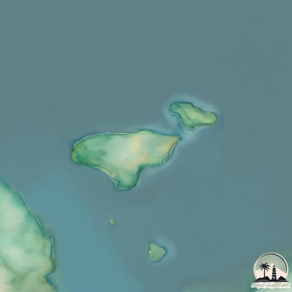
Welcome to Inishillintry, a Temperate island in the North Atlantic Ocean, part of the majestic Atlantic Ocean. This guide offers a comprehensive overview of what makes Inishillintry unique – from its geography and climate to its population, infrastructure, and beyond. Dive into the details:
Geography and size of Inishillintry
Size: 0.113 km²
Coastline: 1.9 km
Ocean: Atlantic Ocean
Sea: North Atlantic Ocean
Continent: Europe
Inishillintry is a Tiny Island spanning 0.113 km² with a coastline of 1.9 km.
Archipel: British Isles – A group of islands off the northwest coast of mainland Europe, including Great Britain, Ireland, and over 6,000 smaller islands, known for their rich history and cultural diversity.
Tectonic Plate: Eurasia – One of the world’s largest tectonic plates, the Eurasian Plate covers a significant portion of Europe and Asia. It’s characterized by diverse geological features, including the Ural Mountains, the European Plain, and the Himalayas formed from its collision with the Indian Plate.
The geographic heart of the island is pinpointed at these coordinates:
Latitude: 55.04431541 / Longitude: -8.41089322
Climate and weather of Inishillintry
Climate Zone: Temperate
Climate Details: Temperate Oceanic Climate
Temperature: Warm Summer
Climate Characteristics: Known for its moderate year-round temperatures with ample rainfall and no dry season. Warm summers are characteristic.
Topography and nature of Inishillintry
Timezone: UTC±00:00
Timezone places: Europe/London
Max. Elevation: -12 m
Mean Elevation: -12 m
Vegetation: Evergreen Needleleaf Forest
Tree Coverage: 10%
The mean elevation is -12 m. Remarkably, this unique island barely emerges above the sea level, showcasing nature’s fascinating interplay with the ocean. The island is characterized by Plains: Flat, low-lying lands characterized by a maximum elevation of up to 200 meters. On islands, plains are typically coastal lowlands or central flat areas.
Dominating Vegetation: Evergreen Needleleaf Forest
Dominated by evergreen coniferous trees such as pines and firs, which retain their needle-like leaves throughout the year. These forests are often found in cooler climates. Inishillintry has a tree cover of 10 %.
Vegetation: 2 vegetation zones – Low Diversity Island
Islands with two distinct vegetation zones offer slightly more ecological variety. These zones could be due to differences in elevation, moisture, or other environmental factors. While still limited in biodiversity, these islands may offer a contrast between the two zones, such as a coastline with mangroves and an inland area with grassland.
Infrastructure and Travelling to Inishillintry
Does the island have a public airport? no.
There is no public and scheduled airport on Inishillintry. The nearest airport is Donegal Airport, located 7 km away.
Does the island have a major port? no.
There are no major ports on Inishillintry. The closest major port is KILLYBEGS, approximately 46 km away.
The mean population of Inishillintry is 15 per km². Inishillintry is Gently Populated. The island belongs to Ireland.
Continuing your journey, Aran Island is the next notable island, situated merely km away.
Inishtrahull Island-Co. Donegal, Ireland
Inishtrahull Island-Co. Donegal, Ireland
Inishkea Islands Mayo
Take a tour to the Inishkea Islands with Caroline Keane as she ...
Take a tour to the Inishkea Islands with Caroline Keane as she explores the remote islands of Inishglora, Inishkea North and ...
Quarantine Island - Inchkeith | Scotland From The Sky | BBC Scotland
Inchkeith Island, near Edinburgh, has a dark history, and was dubbed ...
Inchkeith Island, near Edinburgh, has a dark history, and was dubbed 'quarantine island' as a result of what it was used for many ...
Inishbofin- an aerial tour
an aerial view of Inishboffin island. video shows boffin harbour, the ...
an aerial view of Inishboffin island. video shows boffin harbour, the island profile, Cromwell's fort/barracks knock, Cloonamore, ...
Inchkeith - the abandoned Scottish island with a mysterious past
From bizarre experiments in the 15th century to its time as a refuge ...
From bizarre experiments in the 15th century to its time as a refuge to its involvement in world wars... More from Lost Scotland ...
Inishbofin Island Life, Co. Galway, Ireland 1977
The wild weather, lack of employment and a dwindling population are ...
The wild weather, lack of employment and a dwindling population are all part of life for the island dwellers of Inishbofin. While it ...
RTE's Famous Kathryn Thomas on the Inishkea Islands
Check out the video above featuring RTE's famous Kathryn Thomas on the ...
Check out the video above featuring RTE's famous Kathryn Thomas on the Inishkea Islands with us!
Solo eFoil to Abandoned WW2 Island Inchkeith Scotland 2024
Heading from Pettycur Bay to Inchkeith Island in the Firth of Forth, ...
Heading from Pettycur Bay to Inchkeith Island in the Firth of Forth, take a walk around the island! Timecodes 0:00 - Intro 0:21 ...
Drone footage captures one of Ireland’s most beautiful forgotten Atlantic islands
Inishkea, situated off the coast of the Mullet peninsula, is one of ...
Inishkea, situated off the coast of the Mullet peninsula, is one of the ultimate Wild Atlantic Way stops.
Garvellachs, Insh and Easedale Islands
Second paddle to the Garvellachs as Strava stopped recording during my ...
Second paddle to the Garvellachs as Strava stopped recording during my first one a couple of days ago. I decided to wind my way ...
Inishtrahull Island School & old Lighthouse.
Inishtrahull Island School & old Lighthouse and graveyard.
Inishtrahull Island School & old Lighthouse and graveyard.
The island underneath the Forth Bridge - Inchgarvie
Inishtrahull Island, Co Donegal, Ireland.
Film I made on this island 6 miles north of Malin Head.
Film I made on this island 6 miles north of Malin Head.
The irish fairytale that may be real #wormhole #adventure #history #mystery
wormholeswormholes #explainedwormholetheory #wormhole #inismore ...
wormholeswormholes #explainedwormholetheory #wormhole #inismore #aranislands #ireland #naturalwonder #mystery ...
The UK’s most Inaccessible Island
Subscribe and turn on notifications so you don't miss any videos: ...
Take a fly around Inishtrahull Island
10km off the Irish coast in the Atlantic Ocean lies Inishtrahull ...
10km off the Irish coast in the Atlantic Ocean lies Inishtrahull Island, Ireland's most northernly island. Once home to a vibrant ...
The Old Days on Inishbofin Island, Co. Donegal, Ireland 1986
Inishbofin was once a thriving community with its own school, town ...
Inishbofin was once a thriving community with its own school, town hall and church. Now only five people, two women and three ...
ghostly deserted Inishkea island
keem Bay with my sketchbook and St Patrick.
keem Bay with my sketchbook and St Patrick.
The Iniskea Island Mysteries?
The Iniskea Islands are among the most remote places in Ireland. ...
The Iniskea Islands are among the most remote places in Ireland. Although deserted today, throughout the 19th century the lives ...
Exploring Inishbofin Island, Ireland | Bike Tour
The literal meaning of Inidhbofin is the Island of the White Cow. It ...
The literal meaning of Inidhbofin is the Island of the White Cow. It lies seven miles off the mainland coast. The size of the island is ...
Cows Leap Off Boat and Swim to Irish Island for Grazing
Inishkea Island - Belmullet, Co.Mayo Book your adventure to the Inishkea Island Blacksod Sea Safari
A hidden gem along the Wild Atlantic Way ✨ Tucked away off the coast ...
A hidden gem along the Wild Atlantic Way ✨ Tucked away off the coast of Mayo, Inishkea Island is a place of turquoise waters, ...
Inishbofin Island – The Island Gem You Need to Visit!🏝️
Looking for the best day trip in Connemara? Take the ferry from ...
Looking for the best day trip in Connemara? Take the ferry from Cleggan Pier to Inishbofin Island, one of the most beautiful and ...
Wild Atlantic Way Photography Journey to Inishbofin Island
Join me on a photography journey to Inishbofin Island, a hidden gem ...
Join me on a photography journey to Inishbofin Island, a hidden gem off the coast of Galway on Ireland's famous Wild Atlantic Way ...
Inishkea Island Trips with Belmullet Boat Charters
Thinking about visiting the famous Inishkea Islands this year? Check ...
Thinking about visiting the famous Inishkea Islands this year? Check out some clips from our past trips above! The Inishkea ...
Ireland is classified as Developed region: nonG7: Developed economies outside of the Group of Seven, characterized by high income and advanced economic structures. The level of income is High income: OECD.
News – Latest Updates and Headlines from Inishillintry
Stay informed with the most recent news and important headlines from Inishillintry. Here’s a roundup of the latest developments.
Loading...
Please note: The data used here has been primarily extracted from satellite readings. Deviations from exact values may occur, particularly regarding the height of elevations and population density. Land area and coastline measurements refer to average values at mean high tide.