Welcome to Inishkea South, a Temperate island in the North Atlantic Ocean, part of the majestic Atlantic Ocean. This guide offers a comprehensive overview of what makes Inishkea South unique – from its geography and climate to its population, infrastructure, and beyond. Dive into the details:
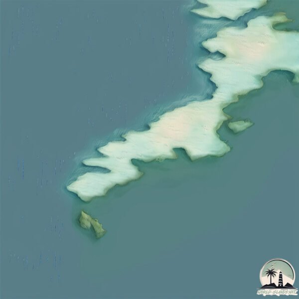
Geography and size of Inishkea South
Size: 1.989 km²
Coastline: 10.7 km
Ocean: Atlantic Ocean
Sea: North Atlantic Ocean
Continent: Europe
Inishkea South is a Small Island spanning 2 km² with a coastline of 10.7 km.
Archipel: British Isles – A group of islands off the northwest coast of mainland Europe, including Great Britain, Ireland, and over 6,000 smaller islands, known for their rich history and cultural diversity.
Tectonic Plate: Eurasia – One of the world’s largest tectonic plates, the Eurasian Plate covers a significant portion of Europe and Asia. It’s characterized by diverse geological features, including the Ural Mountains, the European Plain, and the Himalayas formed from its collision with the Indian Plate.
The geographic heart of the island is pinpointed at these coordinates:
Latitude: 54.11447951 / Longitude: -10.22013764
Climate and weather of Inishkea South
Climate Zone: Temperate
Climate Details: Temperate Oceanic Climate
Temperature: Warm Summer
Climate Characteristics: Known for its moderate year-round temperatures with ample rainfall and no dry season. Warm summers are characteristic.
Topography and nature of Inishkea South
Timezone: UTC±00:00
Timezone places: Europe/London
Max. Elevation: 17 m
Mean Elevation: 8 m
Vegetation: Evergreen Needleleaf Forest
Tree Coverage: 38%
The mean elevation is 8 m. The highest elevation on the island reaches approximately 17 meters above sea level. The island is characterized by Plains: Flat, low-lying lands characterized by a maximum elevation of up to 200 meters. On islands, plains are typically coastal lowlands or central flat areas.
Dominating Vegetation: Evergreen Needleleaf Forest
Dominated by evergreen coniferous trees such as pines and firs, which retain their needle-like leaves throughout the year. These forests are often found in cooler climates. Inishkea South has a tree cover of 38 %.
Vegetation: 5 vegetation zones – Highly Diverse Island
With five different vegetation zones, these islands offer a rich tapestry of ecosystems. The variety could include dense forests, open meadows, wetlands, coastal zones, and more. This level of diversity supports an intricate web of life, with each zone playing a vital role in the overall ecological health and balance of the island.
Infrastructure and Travelling to Inishkea South
Does the island have a public airport? no.
There is no public and scheduled airport on Inishkea South. The nearest airport is Inishmore Aerodrome, located 128 km away.
Does the island have a major port? no.
There are no major ports on Inishkea South. The closest major port is WESTPORT, approximately 82 km away.
The mean population of Inishkea South is 14 per km². Inishkea South is Gently Populated. The island belongs to Ireland.
Continuing your journey, Achill Island is the next notable island, situated merely km away.
Inishkea Islands Mayo
Take a tour to the Inishkea Islands with Caroline Keane as she explores the remote islands of Inishglora, Inishkea North and ...Inishkea Islands Mayo
Take a tour to the Inishkea Islands with Caroline Keane as she ...
Take a tour to the Inishkea Islands with Caroline Keane as she explores the remote islands of Inishglora, Inishkea North and ...
Inishkea Island Trips with Belmullet Boat Charters
Thinking about visiting the famous Inishkea Islands this year? Check ...
Thinking about visiting the famous Inishkea Islands this year? Check out some clips from our past trips above! The Inishkea ...
RTE's Famous Kathryn Thomas on the Inishkea Islands
Check out the video above featuring RTE's famous Kathryn Thomas on the ...
Check out the video above featuring RTE's famous Kathryn Thomas on the Inishkea Islands with us!
Inishkea Whaling Station - Belmullet Boat Charters
Whaling Afloat and Ashore is a 12 minute long film made by Robert ...
Whaling Afloat and Ashore is a 12 minute long film made by Robert William Paul (1869-1943) a London born inventor and ...
Innishkea South: The Island
A walk around Innishkea Island. 16.08.2015.
A walk around Innishkea Island. 16.08.2015.
Innishkea Island South.
James O Doherty Introduces Innishkea Island South. 16.08.2015 The ...
James O Doherty Introduces Innishkea Island South. 16.08.2015 The Inishkea Islands (Goose Islands, Irish: Inis Gé) are situated ...
Inishkea Island - Belmullet, Co.Mayo Book your adventure to the Inishkea Island Blacksod Sea Safari
A hidden gem along the Wild Atlantic Way ✨ Tucked away off the coast ...
A hidden gem along the Wild Atlantic Way ✨ Tucked away off the coast of Mayo, Inishkea Island is a place of turquoise waters, ...
Inishkea Island Trip & Tour
Inishkea Island Trip & Tour - Belmullet Boat Charters The Inishkea ...
Inishkea Island Trip & Tour - Belmullet Boat Charters The Inishkea Islands are located 3km off the coast of Belmullet, Co. Mayo ...
Innishkea South: Abandoned Houses
Abandoned houses on Innishkea Island South off the Mayo coast. ...
Abandoned houses on Innishkea Island South off the Mayo coast. 16.08.2015. The Inishkea Islands (Goose Islands, Irish: Inis Gé) ...
#inishkea #islands #belmullet #mayo #urbex #fyp
Trip to Inishkea! #inishkea #islands #belmullet #mayo #urbex #fyp
Exploring the Inishkea islands
The Inishkea Islands are located 3km off the coast of Belmullet, Co. ...
The Inishkea Islands are located 3km off the coast of Belmullet, Co. Mayo, Ireland. Experience the breath taking views, crystal ...
Traveling out to the Inishkea islands
Thinking about visiting the famous Inishkea Islands this year? Check ...
Thinking about visiting the famous Inishkea Islands this year? Check out some clips from our past trips above! Experience the ...
Drone footage captures one of Ireland’s most beautiful forgotten Atlantic islands
Inishkea, situated off the coast of the Mullet peninsula, is one of ...
Inishkea, situated off the coast of the Mullet peninsula, is one of the ultimate Wild Atlantic Way stops.
Ultimate Adventure in North Mayo, Ireland for 2025 #dolphin #boat #ocean #sea
Looking for an ultimate adventure in 2025? Set sail to the ...
Looking for an ultimate adventure in 2025? Set sail to the breathtaking Inishkea Islands ✨ From crystal-clear waters to ...
Inishkea Islands, Co. Mayo. Pirates, Poitín and the Colour Purple.
Inishkea Islands, Co. Mayo, Ireland. The little known INISHKEA ISLANDS ...
Inishkea Islands, Co. Mayo, Ireland. The little known INISHKEA ISLANDS lie off the Mullet Peninsula on the west coast of Mayo.
Inishkea Islands, Mayo,Ireland
Dolphins following Belmullet Boat Charters
Check out some bottle nose dolphins following Belmullet Boat Charters ...
Check out some bottle nose dolphins following Belmullet Boat Charters on our way to the famous Inishkea Islands located off the ...
Inishkea Islands
North Mayo Sea Kayakers trip to Inishkea islands Co Mayo today.
North Mayo Sea Kayakers trip to Inishkea islands Co Mayo today.
Check out Bottlenose Dolphins following us to the Inishkea Islands #dolphins #ocean #wildlife
Dolphins Caught Fighting near inishkea #dolphins #wildlife #irishsea #ocean
Inishkea Island & Wildlife Safari with Blacksod Sea Safari 🌊
How to never drown at sea in Ireland
When I was home in Mayo recently I took a roadtrip along the Wild ...
When I was home in Mayo recently I took a roadtrip along the Wild Atlantic Way to Blacksod, where I hopped on a ...
Exploring the islands abandoned by the Irish speaking community
When I was home in Mayo recently I took a roadtrip along the Wild ...
When I was home in Mayo recently I took a roadtrip along the Wild Atlantic Way to Blacksod, where I hopped on a ...
Ireland is classified as Developed region: nonG7: Developed economies outside of the Group of Seven, characterized by high income and advanced economic structures. The level of income is High income: OECD.
News – Latest Updates and Headlines from Inishkea South
Stay informed with the most recent news and important headlines from Inishkea South. Here’s a roundup of the latest developments.
Loading...
Please note: The data used here has been primarily extracted from satellite readings. Deviations from exact values may occur, particularly regarding the height of elevations and population density. Land area and coastline measurements refer to average values at mean high tide.