Isla Bister
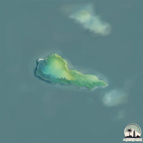
Welcome to Isla Bister, a Temperate island in the South Pacific Ocean, part of the majestic Pacific Ocean. This guide offers a comprehensive overview of what makes Isla Bister unique – from its geography and climate to its population, infrastructure, and beyond. Dive into the details:
- Geography and Size: Explore the island’s size and location.
- Climate and Weather: Weather patterns and temperature.
- Topography and Nature: Uncover the natural wonders of the island.
- Infrastructure and Travelling: Insights on reaching, staying, and making the most of your visit.
- News and Headlines: Latest News.
Geography and size of Isla Bister
Size: 0.335 km²
Coastline: 3.4 km
Ocean: Pacific Ocean
Sea: South Pacific Ocean
Continent: South America
Isla Bister is a Tiny Island spanning 0.335 km² with a coastline of 3.4 km.
Archipel: –
Tectonic Plate: South America – A major plate covering the South American continent and part of the Atlantic Ocean, known for the Andes mountain range and significant seismic and volcanic activity.
The geographic heart of the island is pinpointed at these coordinates:
Latitude: -45.73330113 / Longitude: -74.86078457
Climate and weather of Isla Bister
Climate Zone: Temperate
Climate Details: Temperate Oceanic Climate
Temperature: Warm Summer
Climate Characteristics: Known for its moderate year-round temperatures with ample rainfall and no dry season. Warm summers are characteristic.
Topography and nature of Isla Bister
Timezone: UTC-04:00
Timezone places: America/La_Paz
Max. Elevation: 6 m
Mean Elevation: 2 m
Vegetation: Evergreen Broadleaf Forest
Tree Coverage: 87%
The mean elevation is 2 m. The highest elevation on the island reaches approximately 6 meters above sea level. The island is characterized by Plains: Flat, low-lying lands characterized by a maximum elevation of up to 200 meters. On islands, plains are typically coastal lowlands or central flat areas.
Dominating Vegetation: Evergreen Broadleaf Forest
Characterized by dense, lush canopies of broadleaf trees that retain their leaves year-round. These forests are typically found in tropical and subtropical regions and are known for their high biodiversity. Isla Bister has a tree cover of 87 %.
Vegetation: 1 vegetation zones – Minimal Diversity Island
These islands exhibit the most basic level of ecological diversity, often characterized by a single dominant vegetation type. This could be due to extreme environmental conditions, limited land area, or significant human impact. They represent unique ecosystems where specific species have adapted to thrive in these singular environments.
Infrastructure and Travelling to Isla Bister
Does the island have a public airport? no.
There is no public and scheduled airport on Isla Bister. The nearest airport is Balmaceda Airport, located 352 km away.
Does the island have a major port? no.
There are no major ports on Isla Bister. The closest major port is PUERTO CHACABUCO, approximately 226 km away.
The mean population of Isla Bister is 1 per km². Isla Bister is Gently Populated. The island belongs to Chile.
Continuing your journey, Tenquehuen is the next notable island, situated merely km away.
$1 vs $250,000,000 Private Island!


Chile is classified as Emerging region: G20: Group of Twenty – Major economies comprising both developed and emerging countries, representing the world’s largest economies. The level of income is Upper middle income.
News – Latest Updates and Headlines from Isla Bister
Stay informed with the most recent news and important headlines from Isla Bister. Here’s a roundup of the latest developments.
Please note: The data used here has been primarily extracted from satellite readings. Deviations from exact values may occur, particularly regarding the height of elevations and population density. Land area and coastline measurements refer to average values at mean high tide.