Isla Chata
Welcome to Isla Chata, a Polar island in the South Pacific Ocean, part of the majestic Pacific Ocean. This guide offers a comprehensive overview of what makes Isla Chata unique – from its geography and climate to its population, infrastructure, and beyond. Dive into the details:
- Geography and Size: Explore the island’s size and location.
- Climate and Weather: Weather patterns and temperature.
- Topography and Nature: Uncover the natural wonders of the island.
- Infrastructure and Travelling: Insights on reaching, staying, and making the most of your visit.
- News and Headlines: Latest News.
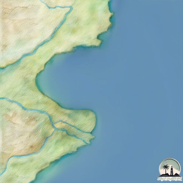
Geography and size of Isla Chata
Size: 0.125 km²
Coastline: 2 km
Ocean: Pacific Ocean
Sea: South Pacific Ocean
Continent: South America
Isla Chata is a Tiny Island spanning 0.125 km² with a coastline of 2 km.
Archipel: –
Tectonic Plate: Scotia – Situated in the Southern Ocean, surrounding the Scotia Sea, between South America and Antarctica, known for the Scotia Arc and active seismicity.
The geographic heart of the island is pinpointed at these coordinates:
Latitude: -54.89158716 / Longitude: -67.38616493
Climate and weather of Isla Chata
Climate Zone: Polar
Climate Details: Tundra
Temperature: Cold
Climate Characteristics: The tundra climate features long, extremely cold winters and short, cool summers. Vegetation is limited to mosses, lichens, and small shrubs due to the low temperatures and short growing seasons. Biodiversity is low, but some specialized species thrive.
Topography and nature of Isla Chata
Timezone: UTC-03:00
Timezone places: America/Sao_Paulo
Max. Elevation: 7 m
Mean Elevation: 0 m
Vegetation: Wetland
Tree Coverage: 85%
The mean elevation is 0 m. The highest elevation on the island reaches approximately 7 meters above sea level. The island is characterized by Plains: Flat, low-lying lands characterized by a maximum elevation of up to 200 meters. On islands, plains are typically coastal lowlands or central flat areas.
Dominating Vegetation: Wetland
These areas are saturated with water, either permanently or seasonally, and support aquatic plants. Wetlands are important for biodiversity and water filtration. Isla Chata has a tree cover of 85 %.
Vegetation: 2 vegetation zones – Low Diversity Island
Islands with two distinct vegetation zones offer slightly more ecological variety. These zones could be due to differences in elevation, moisture, or other environmental factors. While still limited in biodiversity, these islands may offer a contrast between the two zones, such as a coastline with mangroves and an inland area with grassland.
Infrastructure and Travelling to Isla Chata
Does the island have a public airport? no.
There is no public and scheduled airport on Isla Chata. The nearest airport is Malvinas Argentinas Airport, located 100 km away.
Does the island have a major port? no.
There are no major ports on Isla Chata. The closest major port is PUERTO WILLIAMS, approximately 23 km away.
The mean population of Isla Chata is 3 per km². Isla Chata is Gently Populated. The island belongs to Chile.
The name of the island resonates across different cultures and languages. Here is how it is known around the world: Arabic: أرض النار; German: Feuerland; Spanish: Archipiélago de Tierra del Fuego; French: Terre de Feu; Portuguese: Terra do Fogo; Russian: Огненная Земля; Chinese: 火地群島
Continuing your journey, Islas de Tierra del Fuego is the next notable island, situated merely km away.
"Shutter Island" - Official Trailer [HD]
!["Shutter Island" - Official Trailer [HD]](https://i.ytimg.com/vi/5iaYLCiq5RM/mqdefault.jpg)

Chile is classified as Emerging region: G20: Group of Twenty – Major economies comprising both developed and emerging countries, representing the world’s largest economies. The level of income is Upper middle income.
News – Latest Updates and Headlines from Isla Chata
Stay informed with the most recent news and important headlines from Isla Chata. Here’s a roundup of the latest developments.
Please note: The data used here has been primarily extracted from satellite readings. Deviations from exact values may occur, particularly regarding the height of elevations and population density. Land area and coastline measurements refer to average values at mean high tide.