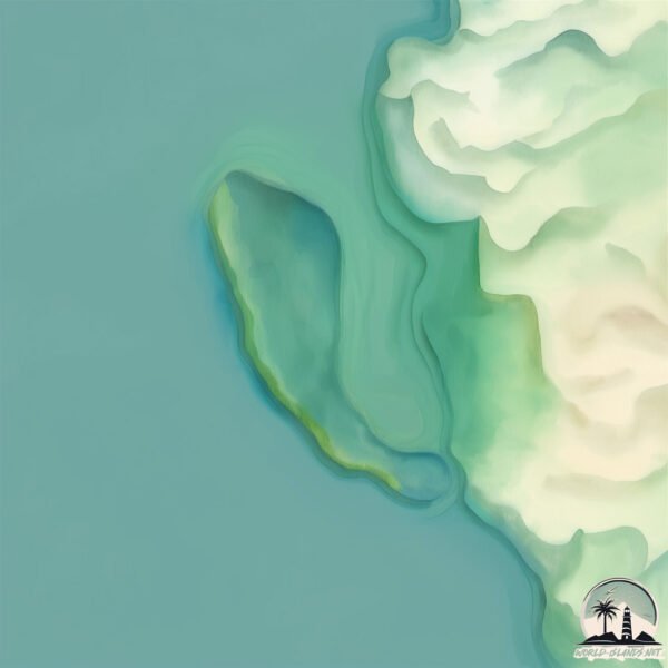
Welcome to Isla Cocosolo, a Tropical island in the Caribbean Sea, part of the majestic Atlantic Ocean. This guide offers a comprehensive overview of what makes Isla Cocosolo unique – from its geography and climate to its population, infrastructure, and beyond. Dive into the details:
Geography and size of Isla Cocosolo
Size: 0.181 km²
Coastline: 2.3 km
Ocean: Atlantic Ocean
Sea: Caribbean Sea
Continent: South America
Isla Cocosolo is a Tiny Island spanning 0.181 km² with a coastline of 2.3 km.
Archipel: –
Tectonic Plate: North Andes – Located in South America, covering Colombia, Ecuador, and part of Venezuela, it is known for its seismic activity due to interactions with the South American Plate.
The geographic heart of the island is pinpointed at these coordinates:
Latitude: 10.35094907 / Longitude: -75.51369088
Climate and weather of Isla Cocosolo
Climate Zone: Tropical
Climate Details: Tropical Savanna, Wet
Temperature: Hot
Climate Characteristics: Defined by distinct wet and dry seasons with high temperatures year-round. Pronounced rainfall occurs during the wet season, while the dry season is marked by drought.
Topography and nature of Isla Cocosolo
Timezone: UTC-05:00
Timezone places: America/New_York
Max. Elevation: 4 m
Mean Elevation: 2 m
Vegetation: Evergreen Broadleaf Forest
Tree Coverage: 1%
The mean elevation is 2 m. The highest elevation on the island reaches approximately 4 meters above sea level. The island is characterized by Plains: Flat, low-lying lands characterized by a maximum elevation of up to 200 meters. On islands, plains are typically coastal lowlands or central flat areas.
Dominating Vegetation: Evergreen Broadleaf Forest
Characterized by dense, lush canopies of broadleaf trees that retain their leaves year-round. These forests are typically found in tropical and subtropical regions and are known for their high biodiversity. Isla Cocosolo has a tree cover of 1 %.
Vegetation: 2 vegetation zones – Low Diversity Island
Islands with two distinct vegetation zones offer slightly more ecological variety. These zones could be due to differences in elevation, moisture, or other environmental factors. While still limited in biodiversity, these islands may offer a contrast between the two zones, such as a coastline with mangroves and an inland area with grassland.
Infrastructure and Travelling to Isla Cocosolo
Does the island have a public airport? no.
There is no public and scheduled airport on Isla Cocosolo. The nearest airport is Rafael Nuñez International Airport, located 10 km away.
Does the island have a major port? no.
There are no major ports on Isla Cocosolo. The closest major port is MAMONAL, approximately 3 km away.
The mean population of Isla Cocosolo is 2154 per km². Isla Cocosolo is Densely Populated. The island belongs to Colombia.
Continuing your journey, Isla Tierra Bomba is the next notable island, situated merely km away.
Cocosolo - Ecolodge en Hermosa playa de Manabí Ecuador
Este video fue filmado en las hermosas playas del pacifico ecuatoriano, en un placentero lugar llamado Cocosolo Ecolodge.Cocosolo - Ecolodge en Hermosa playa de Manabí Ecuador
Este video fue filmado en las hermosas playas del pacifico ...
Este video fue filmado en las hermosas playas del pacifico ecuatoriano, en un placentero lugar llamado Cocosolo Ecolodge.
🌴✨ Isla Coco, el paraíso escondido de Coiba 🏝️🐠
Aguas cristalinas, arenas doradas y una biodiversidad única. Isla ...
Aguas cristalinas, arenas doradas y una biodiversidad única. Isla Coco, en el Parque Nacional Coiba, es uno de los secretos ...
La Isla del Coco a bordo del Okeanos Aggressor II - Cómo llegar a la isla
Una visita a la Isla del Coco en Costa Rica, el lugar que inspiró la ...
Una visita a la Isla del Coco en Costa Rica, el lugar que inspiró la novela y donde se filmaron las escenas aéreas de Jurassic ...
🏖 COCO LOCO , 𝐈𝐒𝐋𝐀𝐒 𝐃𝐄𝐋 𝐑𝐎𝐒𝐀𝐑𝐈𝐎 (𝐂𝐚𝐫𝐭𝐚𝐠𝐞𝐧𝐚, 𝐂𝐨𝐥)
COCO LOCO , ISLAS DEL ROSARIO (Cartagena, Col) Tu pasadía en Islas Del ...
COCO LOCO , ISLAS DEL ROSARIO (Cartagena, Col) Tu pasadía en Islas Del Rosario nunca se ...
95% Of Tourists Have No Idea These 40 Epic Places in Panama Exist
Exclusive Tips & Top Deals! Join the newsletter now ...
Ft. Gulick and Coco Solo
Ft. Gulick, Coco Solo & CHS.
Ft. Gulick, Coco Solo & CHS.
The Coco Solo Hospital.Panamá
The larger Coco Solo Hospital was constructed in the summer of 1941. ...
The larger Coco Solo Hospital was constructed in the summer of 1941. US Senator John McCain was born in 1936 at a small ...
Leaving Isla Holbox | Places to Eat in Isla Holbox With Pricing | Punta Cocos | Holbox Murals
I'm sad to say, we are leaving Isla Holbox. In this video we share our ...
I'm sad to say, we are leaving Isla Holbox. In this video we share our last day in Isla Holbox, affordable places we had breakfast ...
Conozcamos Isla Mamey en Colón #Panamá #paradise #beach #travel
Galeta Island and France Field
Discusses Galeta Island and France Field, Panama Canal Zone giving a ...
Discusses Galeta Island and France Field, Panama Canal Zone giving a brief history and description of the former Naval Security ...
Isla Margarita, Panama video compilation
A compilation of video taken from 4 cameras during the collaborative ...
A compilation of video taken from 4 cameras during the collaborative GCRA / STRI / CIAM survey. The video were shot at Isla ...
QUÉ ES MEJOR? 😫🥱 Barú o Islas del Rosario? #baru #cartagena #viajes #viajeros #turismocolombiano
QUÉ ES MEJOR? Barú? O Las Islas del Rosario? AQUI TE CUENTO! SIGUEME ...
QUÉ ES MEJOR? Barú? O Las Islas del Rosario? AQUI TE CUENTO! SIGUEME PARA MÁS CONTENIDO VIAJERO ...
I Shouldn't Have Traveled To Panama Before Learning These 6 Things.
Panama is full of great things to do and can be a #travelers dream ...
Panama is full of great things to do and can be a #travelers dream #vacation but at the same times there are many things you want ...
Galeta Island 2011 1
Visit to Galeta Island, Panama in 2011. Assigned there 1987-88. The ...
Visit to Galeta Island, Panama in 2011. Assigned there 1987-88. The Ops Site was gutted out, dangerous, and eerie.
Cojimíes - La Isla del Sol
En La Actualidad La Península de Cojimíes o como muchos le dicen La ...
En La Actualidad La Península de Cojimíes o como muchos le dicen La Isla de Cojimíes es un Balneario que se ha dedicado en ...
Isla Margarita, Colón (Panamá)
Isla Margarita en la provincia de Colón en Panamá.
Isla Margarita en la provincia de Colón en Panamá.
Just Go Travel Guides: Panama: The Colon Province
Just Go travel guides make the difference by actually showing you the ...
Just Go travel guides make the difference by actually showing you the practical side of your holiday destination.
Latin America's Forbidden City: Colon, Panama
PANAMA We traveled to one of the most dangerous yet culturally rich ...
PANAMA We traveled to one of the most dangerous yet culturally rich cities in the world. Neyah and I walked through Panama's ...
Top10 Recommended Hotels in Holbox Island, Quintana Roo, Mexico
Subscribe to the channel ...
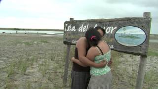
La Isla del Amor en Cojimíes, atractivo turístico ecuatoriano
Galeta Island Ops Site 2011 1
Propuesta de Protecion de la Isla Margarita, Colón (Panamá), Parte I
Propuesta de Protecion de Isla Margarita, Colón (Panamá), Parte I, 1995.
Propuesta de Protecion de Isla Margarita, Colón (Panamá), Parte I, 1995.
BonnieRabbit & Arky Lose Their Minds on the Island #bonnierabbit #arky
BonnieRabbit and Arky slowly lose it during their island survival ...
BonnieRabbit and Arky slowly lose it during their island survival stream. Bonnie eats a leaf that tastes awful, Arky finally cracks ...
Cabanas Isla del Sol Destino 0
Video Promocional.
Video Promocional.
Colombia is classified as Developing region: Regions characterized by lower income levels, with economies in the process of industrialization and modernization. The level of income is Upper middle income.
News – Latest Updates and Headlines from Isla Cocosolo
Stay informed with the most recent news and important headlines from Isla Cocosolo. Here’s a roundup of the latest developments.
Loading...
Please note: The data used here has been primarily extracted from satellite readings. Deviations from exact values may occur, particularly regarding the height of elevations and population density. Land area and coastline measurements refer to average values at mean high tide.