Welcome to Isla Cowley, a Tropical island in the South Pacific Ocean, part of the majestic Pacific Ocean. This guide offers a comprehensive overview of what makes Isla Cowley unique – from its geography and climate to its population, infrastructure, and beyond. Dive into the details:
Geography and size of Isla Cowley
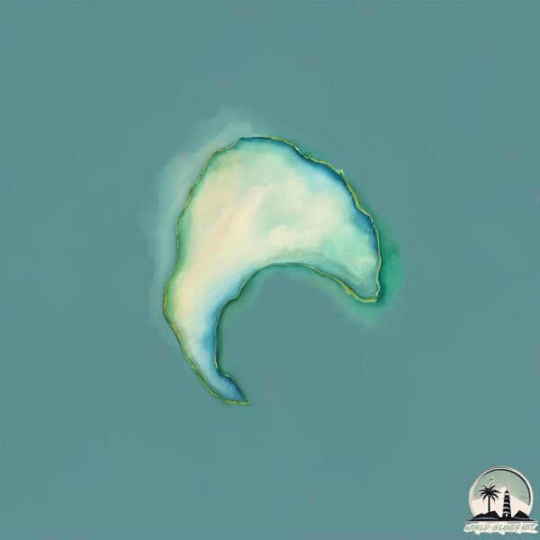
Size: 0.126 km²
Coastline: 1.9 km
Ocean: Pacific Ocean
Sea: South Pacific Ocean
Continent: South America
Isla Cowley is a Tiny Island spanning 0.126 km² with a coastline of 1.9 km.
Archipel: Galapagos Islands – An Ecuadorian archipelago in the Pacific Ocean, famous for their unique wildlife and as a key location for evolutionary studies.
Tectonic Plate: Nazca – An oceanic tectonic plate off the west coast of South America. Famous for the Nazca Lines, it’s primarily known for its subduction under the South American Plate, leading to the Andes Mountains’ formation and significant seismic activity.
The geographic heart of the island is pinpointed at these coordinates:
Latitude: -0.38509931 / Longitude: -90.9612622
Climate and weather of Isla Cowley
Climate Zone: Tropical
Climate Details: Tropical Savanna, Wet
Temperature: Hot
Climate Characteristics: Defined by distinct wet and dry seasons with high temperatures year-round. Pronounced rainfall occurs during the wet season, while the dry season is marked by drought.
Topography and nature of Isla Cowley
Timezone: UTC-06:00
Timezone places: America/Chicago
Max. Elevation: -33 m
Mean Elevation: -34 m
Vegetation: Shrubland
Tree Coverage: 58%
The mean elevation is -34 m. Remarkably, this unique island barely emerges above the sea level, showcasing nature’s fascinating interplay with the ocean. The island is characterized by Plains: Flat, low-lying lands characterized by a maximum elevation of up to 200 meters. On islands, plains are typically coastal lowlands or central flat areas.
Dominating Vegetation: Shrubland
Dominated by shrubs and small bushes, these areas are typical in dry, rocky, or sandy environments, as well as in regions with poor soil fertility. Isla Cowley has a tree cover of 58 %.
Vegetation: 1 vegetation zones – Minimal Diversity Island
These islands exhibit the most basic level of ecological diversity, often characterized by a single dominant vegetation type. This could be due to extreme environmental conditions, limited land area, or significant human impact. They represent unique ecosystems where specific species have adapted to thrive in these singular environments.
Infrastructure and Travelling to Isla Cowley
Does the island have a public airport? no.
There is no public and scheduled airport on Isla Cowley. The nearest airport is General Villamil Airport, located 62 km away.
Does the island have a major port? no.
There are no major ports on Isla Cowley. The closest major port is LA LIBERTAD, approximately 1134 km away.
The mean population of Isla Cowley is 0 per km². Isla Cowley is Uninhabited. The island belongs to Ecuador.
Continuing your journey, Santiago is the next notable island, situated merely km away.
Galápagos sea and wildlife on Isla Isabela or Isabela Island.. - Isabela Island Galapagos - ECTV
Isabela Island (Spanish: Isla Isabela) is the largest of the Galápagos Islands, with an area of 4586 km2 (1771 sq mi) and a length ...Galápagos sea and wildlife on Isla Isabela or Isabela Island.. - Isabela Island Galapagos - ECTV
Isabela Island (Spanish: Isla Isabela) is the largest of the Galápagos ...
Isabela Island (Spanish: Isla Isabela) is the largest of the Galápagos Islands, with an area of 4586 km2 (1771 sq mi) and a length ...
Galapagos Island by prismash
The Galápagos Islands are an archipelago of volcanic islands ...
The Galápagos Islands are an archipelago of volcanic islands distributed around the equator in the Pacific Ocean, 972 km (525 ...
The Galápagos Islands - Archipiélago de Colón -- Ecuador - UNESCO World Heritage Site
See the best accommodation ...
Galapagos, Giant tortoise
The Galápagos Islands (official name: Archipiélago de Colón ; other ...
The Galápagos Islands (official name: Archipiélago de Colón ; other Spanish names: Islas de Colón or Islas Galápagos) are an ...
Galápagos islands
Las islas Galápagos constituyen un archipiélago del océano Pacífico ...
Las islas Galápagos constituyen un archipiélago del océano Pacífico ubicado a 972 km de la costa de Ecuador. Está conformado ...
Initial Walk Through of the Galapagos, Not what I had expected!!! - Isabela Island Galapagos - ECTV
Isabela Island (Spanish: Isla Isabela) is the largest of the Galápagos ...
Isabela Island (Spanish: Isla Isabela) is the largest of the Galápagos Islands, with an area of 4586 km2 (1771 sq mi) and a length ...
Galapagos Islands Travel - Diving With Sea Lions And Shark
The Galapagos Islands are an archipelago of volcanic islands ...
The Galapagos Islands are an archipelago of volcanic islands distributed on either side of the Equator in the Pacific Ocean ...
Galápagos Islands | Wikipedia audio article
This is an audio version of the Wikipedia Article: ...
GALAPAGOS ISLANDS 1929 HOME MOVIE in 16mm KODACOLOR 3322
Possibly the first color footage ever shot in the Galapagos Islands, ...
Possibly the first color footage ever shot in the Galapagos Islands, this exceptional home movie was shot by an unknown traveler ...
GALAPAGOS ISLANDS - ECUADOR
The Galápagos Islands (official name: Archipiélago de Colón, other ...
The Galápagos Islands (official name: Archipiélago de Colón, other Spanish name: Islas Galápagos, pronounced [ˈislas ...
La Casa De Marita on Isabela Island on the Galapagos. Not 4 star! - Isabela Island Galapagos - ECTV
La Casa De Marita on Isabela Island on the Galapagos. Not 4 star! It ...
La Casa De Marita on Isabela Island on the Galapagos. Not 4 star! It might get 1 stars at best. The rooms have ants all over the ...
Langkawi: Is It Better Than Thailand's Paradise Islands?
Langkawi is situated in North West Malaysia right near the Thai ...
Langkawi is situated in North West Malaysia right near the Thai border. Is it worth visiting? Is it paradise? Is it as nice as Thailand?
Remote Places - Location 1 - Isla Isabela, Ecuador
Isabela Island (Spanish pronunciation: [isaˈβela]) is the largest ...
Isabela Island (Spanish pronunciation: [isaˈβela]) is the largest island of the Galápagos with an area of 4640 square kilometres ...
Tame Airline, Santa Cruz Island, Galápagos Islands, Ecuador, South America
The Galápagos Islands are an archipelago of volcanic islands ...
The Galápagos Islands are an archipelago of volcanic islands distributed on either side of the Equator in the Pacific Ocean, 926 ...
Scuba Diving Gone Wrong into Galapagos - The Tragical Story of Eloise Gale!
Cave Exploring Disasters, Cave Disasters, Galapagos Thank you for ...
Cave Exploring Disasters, Cave Disasters, Galapagos Thank you for watching the video! If you enjoyed the video take a dive ...
Islam is the ONLY RELIGION That NOBODY LEAVES | Sheikh Yaboody
Alhamdulillah, did you know Islam is the ONLY religion that NEVER ...
Alhamdulillah, did you know Islam is the ONLY religion that NEVER loses followers? Subhanallah! Support AP: ...
Shutter Island: The truth (HD CLIP)
Shutter Island: The truth What's happening in this Shutter Island ...
Shutter Island: The truth What's happening in this Shutter Island movie clip? Dr. Cawley (Ben Kingsley) reveals a terrible truth to ...
THE TRUE HORROR STORY OF ALEISTER CROWLEY'S OCCULT MANSION | #Shorts
This is the story of the occultist Aleister Crowley and the demonic ...
This is the story of the occultist Aleister Crowley and the demonic spirits he unleased in this terrifying manor house. Subscribe for ...
returning rubbish to fly tipper
Sony A1 Bird Photography on the Greek Island of Lesvos
A recent trip to the Greek Island of Lesvos to witness and photograph ...
A recent trip to the Greek Island of Lesvos to witness and photograph the spring bird migration. Travelling light the Sony A1 and ...
Is LANGKAWI 🇲🇾 REALLY Worth it in 2026? (Watch Before Coming!)
Is LANGKAWI REALLY Worth it in 2026? (Watch Before Coming!) Langkawi, ...
Is LANGKAWI REALLY Worth it in 2026? (Watch Before Coming!) Langkawi, Malaysia's crown jewel of the Andaman Sea, often ...
Fishing, Exploring & Sleeping on Dunk, Bedarra & Wheeler Islands (all you need to know Dunk Island)
Come with us out to Dunk Island, Bedarra Island and Wheeler Island as ...
Come with us out to Dunk Island, Bedarra Island and Wheeler Island as we fish and explore, the absolute beauty of these islands.
Cook Islands Aitu v South African Rhinos | Extended Highlights | Rugby League World Cup Qualifier
Fans outside Australia and the Pacific can now watch full matches ...
PE in American Schools VS British Schools! #schoollife #pe #schoollife #students IB: @VinnyThomas
Where We Lived & Empty House Tour on Ballasalla Isle Of Man Before Moving to Africa. The Cat Died 😢
Where We Lived & Empty House Tour on Ballasalla Isle Of Man Before ...
Where We Lived & Empty House Tour on Ballasalla Isle Of Man Before Moving to Africa. The Cat Died In this video we show ...
Ecuador is classified as Developing region: Regions characterized by lower income levels, with economies in the process of industrialization and modernization. The level of income is Upper middle income.
News – Latest Updates and Headlines from Isla Cowley
Stay informed with the most recent news and important headlines from Isla Cowley. Here’s a roundup of the latest developments.
Loading...
Please note: The data used here has been primarily extracted from satellite readings. Deviations from exact values may occur, particularly regarding the height of elevations and population density. Land area and coastline measurements refer to average values at mean high tide.