Welcome to Isla de la Punta, a Temperate island in the South Atlantic Ocean, part of the majestic Atlantic Ocean. This guide offers a comprehensive overview of what makes Isla de la Punta unique – from its geography and climate to its population, infrastructure, and beyond. Dive into the details:
Geography and size of Isla de la Punta
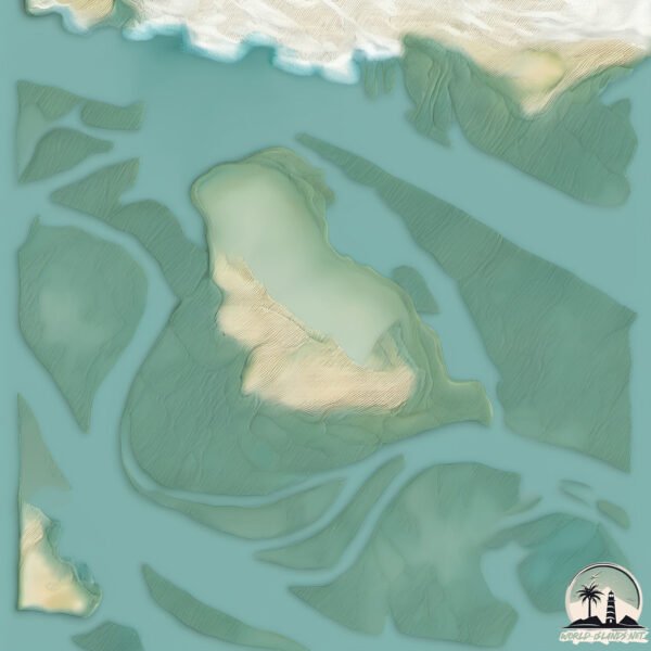
Size: 4.616 km²
Coastline: 16.8 km
Ocean: Atlantic Ocean
Sea: South Atlantic Ocean
Continent: South America
Isla de la Punta is a Small Island spanning 4.6 km² with a coastline of 16.8 km.
Archipel: –
Tectonic Plate: South America – A major plate covering the South American continent and part of the Atlantic Ocean, known for the Andes mountain range and significant seismic and volcanic activity.
The geographic heart of the island is pinpointed at these coordinates:
Latitude: -38.81579489 / Longitude: -62.27022875
Climate and weather of Isla de la Punta
Climate Zone: Temperate
Climate Details: Humid Subtropical Climate
Temperature: Hot Summer
Climate Characteristics: With continuous rainfall and hot summers, this climate is common in some coastal regions, supporting diverse vegetation.
Topography and nature of Isla de la Punta
Timezone: UTC-03:00
Timezone places: America/Sao_Paulo
Max. Elevation: 3 m
Mean Elevation: 0 m
Vegetation: Wetland
Tree Coverage: 82%
The mean elevation is 0 m. The highest elevation on the island reaches approximately 3 meters above sea level. The island is characterized by Plains: Flat, low-lying lands characterized by a maximum elevation of up to 200 meters. On islands, plains are typically coastal lowlands or central flat areas.
Dominating Vegetation: Wetland
These areas are saturated with water, either permanently or seasonally, and support aquatic plants. Wetlands are important for biodiversity and water filtration. Isla de la Punta has a tree cover of 82 %.
Vegetation: 4 vegetation zones – Diverse Island
Four distinct vegetation zones mark these islands as ecologically diverse. They might feature varied landscapes such as forests, beaches, grasslands, and rocky areas. Such diversity reflects the island’s complex ecological interactions and varied habitats, which can support a rich array of wildlife and plant species.
Infrastructure and Travelling to Isla de la Punta
Does the island have a public airport? no.
There is no public and scheduled airport on Isla de la Punta. The nearest airport is Comandante Espora Airport, located 14 km away.
Does the island have a major port? yes.
Isla de la Punta is home to a major port. The following ports are situated on the island: .
The mean population of Isla de la Punta is 3 per km². Isla de la Punta is Gently Populated. The island belongs to Argentina.
Continuing your journey, Isla Bermejo is the next notable island, situated merely km away.
ISLA MUJERES, MEXICO Travel Guide - 10 Things To Do
Order the custom travel itinerary here: https://expluxtravel.com/itinerary 🏙️ 10 Best Things To Do in Isla Mujeres, Mexico 0:00 ...ISLA MUJERES, MEXICO Travel Guide - 10 Things To Do
Order the custom travel itinerary here: ...
You MUST see this Dominican Republic destination! #saonaisland
Saona Island is a bucket list destination! It is a true virgin island ...
Saona Island is a bucket list destination! It is a true virgin island renowned for its breathtaking natural beauty, white sandy ...
ISLA HOLBOX, MEXICO | 5 Things You MUST Do In Isla Holbox
Isla Holbox is a beautiful slice of beach paradise in Mexico! In this ...
Isla Holbox is a beautiful slice of beach paradise in Mexico! In this video, we break down our top things to do in Isla Holbox so you ...
Top 3 Must-Visit Places in Dominican Republic #travel #dominicanrepublic #travelaroundtheworld
Explore Dominican Republica's Hidden Gems - Most Beautiful Places on ...
Explore Dominican Republica's Hidden Gems - Most Beautiful Places on Earth Part 4. Embark on a tropical adventure with us in ...
Punta Cana’s Ultimate Must-Do Top 10 Tours & Day Trips
Ready to book? Check prices & availability here ...
Ready to book? Check prices & availability here ...
Saona Island: Tourist destination in the Dominican Republic - Drone flight #islasaona
Saona Island: A Caribbean paradise that will leave you breathless ...
Saona Island: A Caribbean paradise that will leave you breathless Saona Island is a true treasure of the Caribbean, located ...
Saona Island Dominican Republic.
shorts #vacation #cuba #Mexico #Dominican #beach #resorts.
shorts #vacation #cuba #Mexico #Dominican #beach #resorts.
Descubre la "Isla de Gilligan" en La Punta del Callao 🏝️🌊
En este informe conozca un lugar en el Callao que pocos conocen, Se ...
En este informe conozca un lugar en el Callao que pocos conocen, Se encuentra en la playa de La Punta, detrás de unas ...
Taking a Day Trip to Isla Mujeres, Mexico
Our tour guide took us on a day trip to Isla Mujeres, Mexico and even ...
Our tour guide took us on a day trip to Isla Mujeres, Mexico and even though the beach was beautiful, Isla Mujeres ended up ...
Isla Catalina Tour 2025, from Punta Cana, DR - Is It Worth It? Tour Review
Catalina Island Tour Review (Isla Catalina), Dominican Republic ...
Catalina Island Tour Review (Isla Catalina), Dominican Republic Catalina Island, locally known as Isla Catalina, is a beautiful ...
Isla Mujeres - 5 Things you Need to Know before Going!
In this video I tell you 5 Things that you NEED to KNOW before going ...
In this video I tell you 5 Things that you NEED to KNOW before going to Isla Mujeres, Mexico. We have been to Isla Mujeres 3 ...
La Punta Resort, Isla de Ometepe
🌋🏝️ la isla que nació de dos volcanes: ometepe, nicaragua 🇳🇮 #viralshorts #nicaragua
En el corazón del Lago de Nicaragua se levanta un lugar único en el ...
En el corazón del Lago de Nicaragua se levanta un lugar único en el mundo: la Isla de Ometepe, formada por la unión de dos ...
This is the World's Most Remote Island..
The World's Most Remote Islands are the Pitcairn Islands located in ...
The World's Most Remote Islands are the Pitcairn Islands located in the south pacific ocean. The town here is known as ...
Saona Island Dominican Republic 4K
We go from Punta Cana to Saona Island on a boat tour. We do lots of ...
We go from Punta Cana to Saona Island on a boat tour. We do lots of swimming, dancing and have tons of fun in the Dominican ...
The island of Queimada Grande, where the only living thing is hundreds of thousands of snakes,
The island of Queimada Grande, where the only living thing is hundreds ...
The island of Queimada Grande, where the only living thing is hundreds of thousands of snakes,
Isla de Ometepe Nicaragua #omepeteisland #isladeometepe #nicaragua #edit #youtubeshorts
Calala Island, las vacaciones más caras del mundo | La Hora ¡HOLA!
La isla Calala ubicada en Nicaragua es el lugar favorito de los ...
La isla Calala ubicada en Nicaragua es el lugar favorito de los famosos para disfrutar de la naturaleza y tener privacidad por ...
Saona Island, Dominican Republic is a 4/10 🏝️#dominicanrepublic #puntacana #SaonaIsland #islasaona
Isla De Coche Playa La punta
Lo Mejor De la Isla De Coche.
Lo Mejor De la Isla De Coche.
Top 8 Must Do Things in📍Puerto Vallarta, Mexico 🇲🇽
shorts #shortsyoutube #travel #traveltips #travelblogger #travelvlog ...
shorts #shortsyoutube #travel #traveltips #travelblogger #travelvlog #traveling #mexico #puertovallarta #thingstodo ...
La Isla Saona - Dominican Republic - Review of Excursion
Watch our first review of an excursion that we took to La Isla Saona ...
Watch our first review of an excursion that we took to La Isla Saona in the Dominican Republic. I definitely recommend visiting this ...
Don't Fall for These Cozumel Tourist Traps! Do's & DONT'S
Get Your Tour Tickets Here ...
5 Cosas que debes saber antes de visitar Aruba
The best Catalina Island day trip itinerary ☀️
Who's looking for a full day trip to Catalina Island? Fill your day ...
Who's looking for a full day trip to Catalina Island? Fill your day with sightseeing on a golf cart or jet skiing around Avalon!
Argentina is classified as Emerging region: G20: Group of Twenty – Major economies comprising both developed and emerging countries, representing the world’s largest economies. The level of income is Upper middle income.
News – Latest Updates and Headlines from Isla de la Punta
Stay informed with the most recent news and important headlines from Isla de la Punta. Here’s a roundup of the latest developments.
Loading...
Please note: The data used here has been primarily extracted from satellite readings. Deviations from exact values may occur, particularly regarding the height of elevations and population density. Land area and coastline measurements refer to average values at mean high tide.