Welcome to Isla de Roatán, a Tropical island in the Caribbean Sea, part of the majestic Atlantic Ocean. This guide offers a comprehensive overview of what makes Isla de Roatán unique – from its geography and climate to its population, infrastructure, and beyond. Dive into the details:
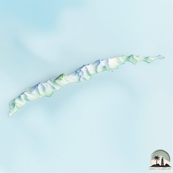
Geography and size of Isla de Roatán
Size: 124.8 km²
Coastline: 156.6 km
Ocean: Atlantic Ocean
Sea: Caribbean Sea
Continent: North America
Isla de Roatán is a Large Island spanning 125 km² with a coastline of 157 km.
Archipel: –
Tectonic Plate: North America – Covers North America and parts of the Atlantic and Arctic Oceans, characterized by diverse geological features and varying levels of seismic activity.
The geographic heart of the island is pinpointed at these coordinates:
Latitude: 16.36645514 / Longitude: -86.4351022
Climate and weather of Isla de Roatán
Climate Zone: Tropical
Climate Details: Tropical Monsoon Climate
Temperature: Hot
Climate Characteristics: Characterized by heavy rainfall, high humidity, and uniformly high temperatures, but with a distinct short dry season. It features a seasonal reversal of prevailing wind directions.
Topography and nature of Isla de Roatán
Timezone: UTC-06:00
Timezone places: America/Chicago
Max. Elevation: 145 m
Mean Elevation: 39 m
Vegetation: Evergreen Broadleaf Forest
Tree Coverage: 76%
The mean elevation is 39 m. The highest elevation on the island reaches approximately 145 meters above sea level. The island is characterized by Plains: Flat, low-lying lands characterized by a maximum elevation of up to 200 meters. On islands, plains are typically coastal lowlands or central flat areas.
Dominating Vegetation: Evergreen Broadleaf Forest
Characterized by dense, lush canopies of broadleaf trees that retain their leaves year-round. These forests are typically found in tropical and subtropical regions and are known for their high biodiversity. Isla de Roatán has a tree cover of 76 %.
Vegetation: 11 vegetation zones – Exceptionally Diverse Island
Islands with more than ten vegetation zones are among the most ecologically rich and varied in the world. These islands are akin to miniature continents, boasting an incredible array of ecosystems. The sheer range of habitats, from high peaks to deep valleys, rainforests to deserts, creates a mosaic of life that is unparalleled. They are crucial for conservation and ecological studies.
Infrastructure and Travelling to Isla de Roatán
Does the island have a public airport? yes.
Isla de Roatán has a public and scheduled airport. The following airports are located on this island: Juan Manuel Gálvez International Airport.
Does the island have a major port? yes.
Isla de Roatán is home to a major port. The following ports are situated on the island: COXEN HOLE.
The mean population of Isla de Roatán is 583 per km². Isla de Roatán is Densely Populated. The island belongs to Honduras.
Continuing your journey, Isla de Utila is the next notable island, situated merely km away.
Roatan Honduras: 8 Best Things To Do In Roatan Honduras
Roatan Honduras Welcome to the tropical paradise of Roatan Honduras, where crystal-clear waters, lush jungles, and vibrant ...Roatan Honduras: 8 Best Things To Do In Roatan Honduras
Roatan Honduras Welcome to the tropical paradise of Roatan Honduras, ...
Roatan Honduras Welcome to the tropical paradise of Roatan Honduras, where crystal-clear waters, lush jungles, and vibrant ...
Roatan Honduras Travel Guide 4K - Top 7 Things To Do & Best Resorts To Stay In
Links to the resorts I mentioned (shortened links will redirect you to ...
Links to the resorts I mentioned (shortened links will redirect you to Expedia) Infinity Bay Spa & Beach Resort ...
Best All Inclusive Resort in Roatan Honduras #travel #cruise #djiavata #drone #beach #infinitybay
Roatan Cruise Port: Best Tips, Must-See Spots & What to Avoid!
Roatan in Honduras is a stunning cruise port with crystal-clear ...
Roatan in Honduras is a stunning cruise port with crystal-clear waters, lush mountains, and some of the best snorkeling in the ...
Landing in Roatan: What You NEED to Know
Just landed in Roatan, Honduras — and if it's your first time flying ...
Just landed in Roatan, Honduras — and if it's your first time flying in, you NEED to see this! From which side of the plane to sit on, ...
Roatan Is Way Cooler Than You Think!
I just got back from Roatán, Honduras—and this Caribbean island ...
I just got back from Roatán, Honduras—and this Caribbean island totally blew me away. From effortless access to vibrant coral ...
DON'T MAKE THIS MISTAKE IN ROATAN HONDURAS: DO THIS INSTEAD! (MSC WORLD AMERICA)
It's day 4 Onboard msc world America and we are in ROATAN HONDURAS ...
It's day 4 Onboard msc world America and we are in ROATAN HONDURAS join us for a fun filled day in port. Will we explore the ...
IS ROATAN SAFE? What to Do in Roatan on a Cruise (& what to avoid)
Are you going to Roatan on a cruise & wondering what to do? Roatan is ...
Are you going to Roatan on a cruise & wondering what to do? Roatan is a cruise port where you're probably better off booking an ...
5 Amazing Things Cruisers Can Do in Roatan
Roatan is a popular cruise ship port of call and cruisers can use this ...
Roatan is a popular cruise ship port of call and cruisers can use this cruise hack to swim for free, or use one of these other cruise ...
Roatan Honduras: 8 Best Things to Do in Roatán, Honduras (2025 Travel Guide)
Roatan Honduras Welcome to Roatán, Honduras — the Caribbean's hidden ...
Roatan Honduras Welcome to Roatán, Honduras — the Caribbean's hidden jewel where turquoise waters, lush green hills, and ...
Best Islands in the Caribbean - Roatan, Honduras - West Bay
I Lived in Roatan Honduras but Didn't Stay - Here's What They Don't Tell Expats
Roatan Honduras Travel Guide | 9 Best Things to Do in 2025
Get ready to explore Roatan Honduras, a Caribbean paradise filled with ...
Get ready to explore Roatan Honduras, a Caribbean paradise filled with adventure, relaxation, and natural beauty. In this travel ...
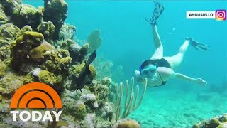
Tour Honduras’ Paradise Island Of Roatán
Boutique hotel owner Talia Greenfield shows Hoda and Jenna a day in ...
Boutique hotel owner Talia Greenfield shows Hoda and Jenna a day in her life living in Roatán, an island off the coast of ...
Unique things to do in Roatan Honduras | Less touristy hidden gems! 4K
OK guys let's explore some of the Unique things to do in Roatan, ...
OK guys let's explore some of the Unique things to do in Roatan, Honduras. In this video I've focused on the less touristy places, ...
What Surprised Us at ROATAN's NEW Cruise Port? - Coxen Hole
Join your favorite YouTube Travel Couple as we take you on a walking ...
Join your favorite YouTube Travel Couple as we take you on a walking tour of the Roatan Cruise Port at Coxen Hole. This Port ...
Roatan, Honduras: 10 Best Places to Visit in Roatán, Honduras (2025 Travel Guide)
Roatan, Honduras Welcome to Roatán, Honduras — a true Caribbean ...
Roatan, Honduras Welcome to Roatán, Honduras — a true Caribbean paradise where turquoise waters, vibrant coral reefs, and ...
Inside Roatan: The Island of Extreme Wealth & Poverty
Book Your Adventure! , Stay at My Place in Roatan, Honduras! ...
Little French Key is Unreal! 📍Roatan, Honduras
What to do in Western Caribbean Cruise Ports | Cozumel, Roatan, Costa Maya, Belize
Ready to embark on an unforgettable Western Caribbean cruise? In this ...
Ready to embark on an unforgettable Western Caribbean cruise? In this 5-minute guide, discover my TOP PICKS for things to do ...
Best Roatan Shore Excursions (Our Favorite Tours in Roatan)
Roatan, Honduras is a very popular port of call for Western Caribbean ...
Roatan, Honduras is a very popular port of call for Western Caribbean cruises with lots of activities offered. We discuss the best ...
Roatan, Honduras CRUISE PORT TOUR, TIPS & TOP THINGS TO DO!
In this video we take you to the breathtaking Caribbean paradise of ...
In this video we take you to the breathtaking Caribbean paradise of Roatán Island, Honduras a lush, tropical escape packed with ...
😍🇭🇳 Lo Mejor de Roatán | Islas de la Bahía Honduras (Joel Seoane)
Te invito a conocer la isla paradisíaca de Roatán en el departamento ...
Te invito a conocer la isla paradisíaca de Roatán en el departamento de Islas de la Bahía en el caribe de Honduras. En este ...
Best Islands in the Caribbean - 📍Roatan, Honduras - Mesoamerican Reef
Why you should go to Roatan? 🇭🇳 #honduras #roatan #travelvideography
Honduras is classified as Developing region: Regions characterized by lower income levels, with economies in the process of industrialization and modernization. The level of income is Lower middle income.
News – Latest Updates and Headlines from Isla de Roatán
Stay informed with the most recent news and important headlines from Isla de Roatán. Here’s a roundup of the latest developments.
Loading...
Please note: The data used here has been primarily extracted from satellite readings. Deviations from exact values may occur, particularly regarding the height of elevations and population density. Land area and coastline measurements refer to average values at mean high tide.