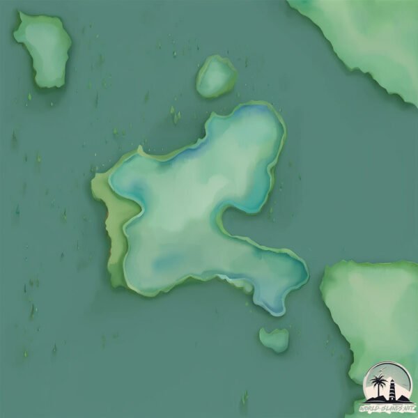
Welcome to Isla Donoso, a Temperate island in the South Pacific Ocean, part of the majestic Pacific Ocean. This guide offers a comprehensive overview of what makes Isla Donoso unique – from its geography and climate to its population, infrastructure, and beyond. Dive into the details:
Geography and size of Isla Donoso
Size: 0.51 km²
Coastline: 4.5 km
Ocean: Pacific Ocean
Sea: South Pacific Ocean
Continent: South America
Isla Donoso is a Tiny Island spanning 0.51 km² with a coastline of 4.5 km.
Archipel: –
Tectonic Plate: South America – A major plate covering the South American continent and part of the Atlantic Ocean, known for the Andes mountain range and significant seismic and volcanic activity.
The geographic heart of the island is pinpointed at these coordinates:
Latitude: -51.75972152 / Longitude: -72.91575431
Climate and weather of Isla Donoso
Climate Zone: Temperate
Climate Details: Subpolar Oceanic Climate
Temperature: Cold Summer
Climate Characteristics: Predominantly cold with cool summers and no dry season. Often found in coastal areas at higher latitudes or on islands.
Topography and nature of Isla Donoso
Timezone: UTC-04:00
Timezone places: America/La_Paz
Max. Elevation: 5 m
Mean Elevation: 4 m
Vegetation: Shrubland
Tree Coverage: 0%
The mean elevation is 4 m. The highest elevation on the island reaches approximately 5 meters above sea level. The island is characterized by Plains: Flat, low-lying lands characterized by a maximum elevation of up to 200 meters. On islands, plains are typically coastal lowlands or central flat areas.
Dominating Vegetation: Shrubland
Dominated by shrubs and small bushes, these areas are typical in dry, rocky, or sandy environments, as well as in regions with poor soil fertility. Isla Donoso has a tree cover of 0 %.
Vegetation: 2 vegetation zones – Low Diversity Island
Islands with two distinct vegetation zones offer slightly more ecological variety. These zones could be due to differences in elevation, moisture, or other environmental factors. While still limited in biodiversity, these islands may offer a contrast between the two zones, such as a coastline with mangroves and an inland area with grassland.
Infrastructure and Travelling to Isla Donoso
Does the island have a public airport? no.
There is no public and scheduled airport on Isla Donoso. The nearest airport is Lieutenant Julio Gallardo Airport, located 44 km away.
Does the island have a major port? no.
There are no major ports on Isla Donoso. The closest major port is PUERTO NATALES, approximately 39 km away.
The mean population of Isla Donoso is 1 per km². Isla Donoso is Uninhabited. The island belongs to Chile.
Continuing your journey, Diego Portales is the next notable island, situated merely km away.
This is the World's Most Remote Island..
The World's Most Remote Islands are the Pitcairn Islands located in the south pacific ocean. The town here is known as ...This is the World's Most Remote Island..
The World's Most Remote Islands are the Pitcairn Islands located in ...
The World's Most Remote Islands are the Pitcairn Islands located in the south pacific ocean. The town here is known as ...
🌊 Ultimate Betrayal on a Deserted Island #shorts
Ultimate Betrayal on a Deserted Island #shorts.
Ultimate Betrayal on a Deserted Island #shorts.
ISLA MUJERES, MEXICO Travel Guide - 10 Things To Do
Order the custom travel itinerary here: ...
The island of Queimada Grande, where the only living thing is hundreds of thousands of snakes,
The island of Queimada Grande, where the only living thing is hundreds ...
The island of Queimada Grande, where the only living thing is hundreds of thousands of snakes,
Why Dolls Hang on This Island?
Madre de Dios: La isla perdida
Los buzos, geólogos y biólogos enfrentan condiciones extremas para ...
Los buzos, geólogos y biólogos enfrentan condiciones extremas para estudiar la inexplorada tierra antártica. ¡Encuéntranos en ...
Isla sorna💀 #edit #viralvideo #jurassicpark #fyp
Isla Mujeres - 5 Things you Need to Know before Going!
In this video I tell you 5 Things that you NEED to KNOW before going ...
In this video I tell you 5 Things that you NEED to KNOW before going to Isla Mujeres, Mexico. We have been to Isla Mujeres 3 ...
Welcome to the beautiful and epic island of St. Lucia 🏝️😍 #BucketlistTravel #caribbean #travelmore
This place is like if Hawaii and Norway had a baby Out of all the ...
This place is like if Hawaii and Norway had a baby Out of all the Caribbean Islands we have been to, this one is our personal ...
Visitando la isla poblada más lejana del mundo | RAPA NUI (Isla de Pascua)
Exploramos Rapa Nui, uno de los territorios más aislados de nuestro ...
Exploramos Rapa Nui, uno de los territorios más aislados de nuestro planeta. Tierras hermosas, sin duda. Cuando estés de viaje ...
Taking a Day Trip to Isla Mujeres, Mexico
Our tour guide took us on a day trip to Isla Mujeres, Mexico and even ...
Our tour guide took us on a day trip to Isla Mujeres, Mexico and even though the beach was beautiful, Isla Mujeres ended up ...
3 Days in Islay | Exploring Scotland's Stunning Whisky Island
3 Days in Islay - Scotland's Stunning Whisky Island In April, me and ...
3 Days in Islay - Scotland's Stunning Whisky Island In April, me and Amy visited Islay, an island off the west coast of Scotland, ...
📍Zamami Island, Okinawa, Japan #marinelife #traveltiktok #japan #okinawa #travelwithtrainpal #vuka
Zamami Island, Okinawa, Japan #marinelife #traveltiktok #japan ...
Zamami Island, Okinawa, Japan #marinelife #traveltiktok #japan #okinawa #travelwithtrainpal #vuka.
Jurassic park in real life in Cocos island (isla nublar)
Visiting The World's Whisky Island | Islay
I visit the Scottish Island of Islay, the world's only whisky island . ...
I visit the Scottish Island of Islay, the world's only whisky island . The Isle of Islay, located on Scotland's west coast is one of ...
Osvaldo Donoso Barrrios' Aquelarre in the Galapagos
The Weirdest Island on Earth!
Ipanumpa Ko - Oh! Caraga | Isla Riddim Reggae Rendition
Ipanumpa ko is originally composed by @OhCaraga.We don't owned this ...
Ipanumpa ko is originally composed by @OhCaraga.We don't owned this song the purpose of covering this piece is to entertain ...
фрози (frozy), Tomo - Islands (kompa pasión) (Lyrics)
фрози (frozy), Tomo - Islands (kompa pasión) Stream/Download: ...
фрози (frozy), Tomo - Islands (kompa pasión) Stream/Download: (Lyrics): [Intro] (frozy) [Chorus: Tomo] She said she's from the ...
Isla de Mona
island #puertorico #taino #googleearth.
island #puertorico #taino #googleearth.
TAILANDIA, ESCUELA PARA NIÑOS VIAJEROS // Ep.18
Esta es nuestra última semana en Tailandia, mamá ha estado un poco ...
Esta es nuestra última semana en Tailandia, mamá ha estado un poco enferma pero cuando se ha sentido mejor, Mathias y ...
The Most Dangerous Island in Jurassic Park / World ☠️
Song by: h6itam Song name: FUNK OSCURO Visual Content: Universal ...
Song by: h6itam Song name: FUNK OSCURO Visual Content: Universal Pictures All footage, music, and images used in this ...
Islas Que Tu No Puedes Visitar 🏝😳 #shorts #curiosidades #isla
Madonna - La Isla Bonita (Lyrics)
Follow the official 7clouds playlist on Spotify : ...
Follow the official 7clouds playlist on Spotify :
http://spoti.fi/2SJsUcZ Madonna - La Isla Bonita (Lyrics) ⏬ Download / Stream: ...
Chile is classified as Emerging region: G20: Group of Twenty – Major economies comprising both developed and emerging countries, representing the world’s largest economies. The level of income is Upper middle income.
News – Latest Updates and Headlines from Isla Donoso
Stay informed with the most recent news and important headlines from Isla Donoso. Here’s a roundup of the latest developments.
Loading...
Please note: The data used here has been primarily extracted from satellite readings. Deviations from exact values may occur, particularly regarding the height of elevations and population density. Land area and coastline measurements refer to average values at mean high tide.