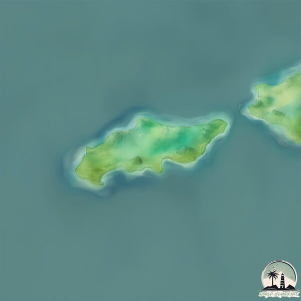
Isla Herradura
Welcome to Isla Herradura, a Tropical island in the North Pacific Ocean, part of the majestic Pacific Ocean. This guide offers a comprehensive overview of what makes Isla Herradura unique – from its geography and climate to its population, infrastructure, and beyond. Dive into the details:
- Geography and Size: Explore the island’s size and location.
- Climate and Weather: Weather patterns and temperature.
- Topography and Nature: Uncover the natural wonders of the island.
- Infrastructure and Travelling: Insights on reaching, staying, and making the most of your visit.
- News and Headlines: Latest News.
Geography and size of Isla Herradura
Size: 0.365 km²
Coastline: 3.1 km
Ocean: Pacific Ocean
Sea: North Pacific Ocean
Continent: North America
Isla Herradura is a Tiny Island spanning 0.365 km² with a coastline of 3.1 km.
Archipel: –
Tectonic Plate: Panama – A small plate in Central America, primarily under Panama and Costa Rica, known for its seismic and volcanic activity due to interactions with the Cocos and Caribbean Plates.
The geographic heart of the island is pinpointed at these coordinates:
Latitude: 9.62870323 / Longitude: -84.6710351
Climate and weather of Isla Herradura
Climate Zone: Tropical
Climate Details: Tropical Savanna, Wet
Temperature: Hot
Climate Characteristics: Defined by distinct wet and dry seasons with high temperatures year-round. Pronounced rainfall occurs during the wet season, while the dry season is marked by drought.
Topography and nature of Isla Herradura
Timezone: UTC-06:00
Timezone places: America/Chicago
Max. Elevation: 29 m
Mean Elevation: 25 m
Vegetation: Evergreen Needleleaf Forest
Tree Coverage: 97%
The mean elevation is 25 m. The highest elevation on the island reaches approximately 29 meters above sea level. The island is characterized by Plains: Flat, low-lying lands characterized by a maximum elevation of up to 200 meters. On islands, plains are typically coastal lowlands or central flat areas.
Dominating Vegetation: Evergreen Needleleaf Forest
Dominated by evergreen coniferous trees such as pines and firs, which retain their needle-like leaves throughout the year. These forests are often found in cooler climates. Isla Herradura has a tree cover of 97 %.
Vegetation: 2 vegetation zones – Low Diversity Island
Islands with two distinct vegetation zones offer slightly more ecological variety. These zones could be due to differences in elevation, moisture, or other environmental factors. While still limited in biodiversity, these islands may offer a contrast between the two zones, such as a coastline with mangroves and an inland area with grassland.
Infrastructure and Travelling to Isla Herradura
Does the island have a public airport? no.
There is no public and scheduled airport on Isla Herradura. The nearest airport is Quepos Managua Airport, located 63 km away.
Does the island have a major port? no.
There are no major ports on Isla Herradura. The closest major port is PUERTO CALDERA, approximately 32 km away.
The mean population of Isla Herradura is 134 per km². Isla Herradura is Moderately Inhabited. The island belongs to Costa Rica.
Continuing your journey, Chira is the next notable island, situated merely km away.
ISLA HERRADURA 2015


Costa Rica is classified as Emerging region: G20: Group of Twenty – Major economies comprising both developed and emerging countries, representing the world’s largest economies. The level of income is Upper middle income.
News – Latest Updates and Headlines from Isla Herradura
Stay informed with the most recent news and important headlines from Isla Herradura. Here’s a roundup of the latest developments.
Please note: The data used here has been primarily extracted from satellite readings. Deviations from exact values may occur, particularly regarding the height of elevations and population density. Land area and coastline measurements refer to average values at mean high tide.